Fouras
Fouras, also known as Fouras-les-Bains (French pronunciation: [fuʁa le bɛ̃]), is a commune in the Charente-Maritime department in the Nouvelle-Aquitaine region in southwestern France. It lies 34 km south of La Rochelle.
Fouras | |
|---|---|
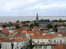 A general view of Fouras | |
 Coat of arms | |
Location of Fouras 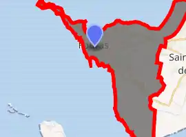
| |
 Fouras  Fouras | |
| Coordinates: 45°59′16″N 1°05′35″W | |
| Country | France |
| Region | Nouvelle-Aquitaine |
| Department | Charente-Maritime |
| Arrondissement | Rochefort |
| Canton | Châtelaillon-Plage |
| Intercommunality | Rochefort |
| Government | |
| • Mayor (2014–2020) | Sylvie Marcilly |
| Area 1 | 9.51 km2 (3.67 sq mi) |
| Population (2017-01-01)[1] | 4,006 |
| • Density | 420/km2 (1,100/sq mi) |
| Time zone | UTC+01:00 (CET) |
| • Summer (DST) | UTC+02:00 (CEST) |
| INSEE/Postal code | 17168 /17450 |
| Elevation | 0–21 m (0–69 ft) |
| 1 French Land Register data, which excludes lakes, ponds, glaciers > 1 km2 (0.386 sq mi or 247 acres) and river estuaries. | |
Geography
Fouras is on a peninsula. It is bordered by five beaches and a forest named "Bois Vert" ("Green Wood" in English) which covers 20% of its area.
It extends into a roadway to discover tide to the low Fort Enet in the direction of the Île-d'Aix. The pier for the island of Aix is also located in the territory of the commune.
The south coast of the peninsula of Fouras forms the northern side of the mouth of the Charente river. A little further south is the Île d'Oléron. Off the island between Aix and the island of Oleron is Fort Boyard, which was made famous by the French TV game show of the same name and whose character "Père Fouras" increased the celebrity of the town.
Population
| Year | Pop. | ±% |
|---|---|---|
| 1793 | 615 | — |
| 1800 | 638 | +3.7% |
| 1806 | 645 | +1.1% |
| 1821 | 736 | +14.1% |
| 1831 | 860 | +16.8% |
| 1836 | 843 | −2.0% |
| 1841 | 800 | −5.1% |
| 1846 | 833 | +4.1% |
| 1851 | 823 | −1.2% |
| 1856 | 870 | +5.7% |
| 1861 | 926 | +6.4% |
| 1866 | 1,028 | +11.0% |
| 1872 | 1,138 | +10.7% |
| 1876 | 1,256 | +10.4% |
| 1881 | 1,679 | +33.7% |
| 1886 | 1,877 | +11.8% |
| 1891 | 1,887 | +0.5% |
| 1896 | 1,989 | +5.4% |
| 1901 | 2,171 | +9.2% |
| 1906 | 2,461 | +13.4% |
| 1911 | 2,499 | +1.5% |
| 1921 | 2,399 | −4.0% |
| 1926 | 2,322 | −3.2% |
| 1931 | 2,166 | −6.7% |
| 1936 | 2,474 | +14.2% |
| 1946 | 3,013 | +21.8% |
| 1954 | 4,068 | +35.0% |
| 1962 | 4,121 | +1.3% |
| 1968 | 3,634 | −11.8% |
| 1975 | 3,612 | −0.6% |
| 1982 | 3,295 | −8.8% |
| 1990 | 3,238 | −1.7% |
| 1999 | 3,835 | +18.4% |
| 2008 | 4,095 | +6.8% |
Vauban fortress
The "Vauban fortress" was initially a strategic fortification established by Philippe le Bel, circa 1300. The donjon was rebuilt in 1480-1490 by Jehan II de Brosse. In 1689, Ferry reinforced the walls of the Donjon to set up a battery of 9 canons and a signaling point. In 1693 a lower circular battery was set up to control access to the Charente River. The donjon received a signal station from 1889 to World War II.[2]
Gallery
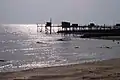 Fisherman's Cabin
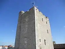 Fouras donjon in the "Vauban fortress" in Fouras.
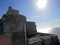 The "Vauban fortress" in Fouras.
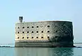 Fort Boyard
People
Twinnings
 , Agia Paraskevi, Greece
 , Geroskipou, Cyprus
References
![]() Media related to Fouras at Wikimedia Commons
Media related to Fouras at Wikimedia Commons
- "Populations légales 2017". INSEE. Retrieved 6 January 2020.
- Local notice
| Authority control |
|---|
