Saint-Fort-sur-Gironde
Saint-Fort-sur-Gironde is a commune in the Charente-Maritime department in southwestern France.
Saint-Fort-sur-Gironde | |
|---|---|
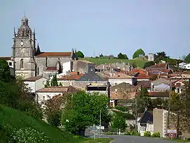 A general view of Saint-Fort-sur-Gironde | |
Location of Saint-Fort-sur-Gironde 
| |
 Saint-Fort-sur-Gironde  Saint-Fort-sur-Gironde | |
| Coordinates: 45°27′38″N 0°43′15″W | |
| Country | France |
| Region | Nouvelle-Aquitaine |
| Department | Charente-Maritime |
| Arrondissement | Jonzac |
| Canton | Pons |
| Intercommunality | Haute-Saintonge |
| Government | |
| • Mayor (2008–2014) | Jean-Pierre Gervreau |
| Area 1 | 24.22 km2 (9.35 sq mi) |
| Population (2017-01-01)[1] | 909 |
| • Density | 38/km2 (97/sq mi) |
| Time zone | UTC+01:00 (CET) |
| • Summer (DST) | UTC+02:00 (CEST) |
| INSEE/Postal code | 17328 /17240 |
| Elevation | 2–70 m (6.6–229.7 ft) (avg. 47 m or 154 ft) |
| 1 French Land Register data, which excludes lakes, ponds, glaciers > 1 km2 (0.386 sq mi or 247 acres) and river estuaries. | |
Population
|
|
References
- "Populations légales 2017". INSEE. Retrieved 6 January 2020.
| Wikimedia Commons has media related to Saint-Fort-sur-Gironde. |
| Authority control |
|
|---|
This article is issued from Wikipedia. The text is licensed under Creative Commons - Attribution - Sharealike. Additional terms may apply for the media files.