Aytré
Aytré is a commune in the Charente-Maritime department in the Nouvelle-Aquitaine region in southwestern France.
Aytré | |
|---|---|
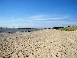 Beach at Aytré | |
.svg.png.webp) Coat of arms | |
Location of Aytré 
| |
 Aytré  Aytré | |
| Coordinates: 46°08′05″N 1°06′48″W | |
| Country | France |
| Region | Nouvelle-Aquitaine |
| Department | Charente-Maritime |
| Arrondissement | La Rochelle |
| Canton | Aytré |
| Intercommunality | CA La Rochelle |
| Government | |
| • Mayor (2014-2020) | Alain Tuillière |
| Area 1 | 12.22 km2 (4.72 sq mi) |
| Population (2017-01-01)[1] | 8,725 |
| • Density | 710/km2 (1,800/sq mi) |
| Time zone | UTC+01:00 (CET) |
| • Summer (DST) | UTC+02:00 (CEST) |
| INSEE/Postal code | 17028 /17440 |
| Elevation | 1–21 m (3.3–68.9 ft) |
| 1 French Land Register data, which excludes lakes, ponds, glaciers > 1 km2 (0.386 sq mi or 247 acres) and river estuaries. | |
Aytré is especially known for its long beach, which is easily accessible from neighbouring La Rochelle, or Les Minimes. The beach is flat and shallow, making it a good bathing spot for children, and an excellent spot for windsurfing.
The historian Jean Prasteau (1921–1997) was born in Aytré, as was Jean Desaguliers, a Protestant pastor, and father of John Theophilus Desaguliers.
Economy
Industries are few, and economic activity mainly gravitates around La Rochelle, with the distinct exception of Alstom Transportation. The world's fastest train, TGV, was designed right in Aytré. Oysters are cultivated in the bay and important camping grounds have been developed for tourists during the summer period.
History
During the Siege of La Rochelle, Cardinal de Richelieu spent time in a farm just to the south of Aytré.
Population
| Year | Pop. | ±% |
|---|---|---|
| 1793 | 1,036 | — |
| 1800 | 758 | −26.8% |
| 1806 | 1,038 | +36.9% |
| 1821 | 1,185 | +14.2% |
| 1831 | 1,320 | +11.4% |
| 1836 | 1,390 | +5.3% |
| 1841 | 1,453 | +4.5% |
| 1846 | 1,451 | −0.1% |
| 1851 | 1,463 | +0.8% |
| 1856 | 1,466 | +0.2% |
| 1861 | 858 | −41.5% |
| 1866 | 837 | −2.4% |
| 1872 | 766 | −8.5% |
| 1876 | 840 | +9.7% |
| 1881 | 923 | +9.9% |
| 1886 | 913 | −1.1% |
| 1891 | 1,019 | +11.6% |
| 1896 | 1,102 | +8.1% |
| 1901 | 1,099 | −0.3% |
| 1906 | 1,149 | +4.5% |
| 1911 | 1,333 | +16.0% |
| 1921 | 1,436 | +7.7% |
| 1926 | 1,645 | +14.6% |
| 1931 | 2,157 | +31.1% |
| 1936 | 2,067 | −4.2% |
| 1946 | 2,335 | +13.0% |
| 1954 | 3,021 | +29.4% |
| 1962 | 5,302 | +75.5% |
| 1968 | 6,197 | +16.9% |
| 1975 | 6,812 | +9.9% |
| 1982 | 7,278 | +6.8% |
| 1990 | 7,786 | +7.0% |
| 1999 | 7,751 | −0.4% |
| 2008 | 8,820 | +13.8% |
| 2014 | 8,821 | +0.0% |
References
- "Populations légales 2017". INSEE. Retrieved 6 January 2020.
External links
| Wikimedia Commons has media related to Aytré. |

| Authority control |
|---|