Saint-Rogatien
Saint-Rogatien is a commune in the Charente-Maritime department in the Nouvelle-Aquitaine region in southwestern France.
Saint-Rogatien | |
|---|---|
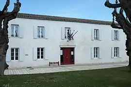 The town hall of Saint-Rogatien | |
Location of Saint-Rogatien 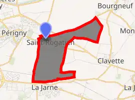
| |
 Saint-Rogatien  Saint-Rogatien | |
| Coordinates: 46°09′08″N 1°04′15″W | |
| Country | France |
| Region | Nouvelle-Aquitaine |
| Department | Charente-Maritime |
| Arrondissement | La Rochelle |
| Canton | La Jarrie |
| Intercommunality | CA La Rochelle |
| Area 1 | 5.19 km2 (2.00 sq mi) |
| Population (2017-01-01)[1] | 2,206 |
| • Density | 430/km2 (1,100/sq mi) |
| Time zone | UTC+01:00 (CET) |
| • Summer (DST) | UTC+02:00 (CEST) |
| INSEE/Postal code | 17391 /17220 |
| Elevation | 9–33 m (30–108 ft) (avg. 16 m or 52 ft) |
| 1 French Land Register data, which excludes lakes, ponds, glaciers > 1 km2 (0.386 sq mi or 247 acres) and river estuaries. | |
Besides the town, the town includes the area of Casse-Mortier and part of the village Pommerou, shared with the town of Clavette.[2] Its inhabitants are called Rogatons and Rogatonnes.[3]
Gallery
.JPG.webp) St Rogatien church
St Rogatien church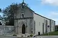 Eglise de Saint-Rogatien
.JPG.webp) Memorial stone
Memorial stone.JPG.webp) The Mairie in Saint-Rogatien
The Mairie in Saint-Rogatien
Église Saint-Rogatien-Saint-Donatien
.JPG.webp)
This church built of limestone in the 12th century and renovated in the 19th century is dedicated to Nantes' two martyrs, partially destroyed during the Wars of Religion, it is largely late medieval but retains its Romanesque portal and a Gothic trefoil recess. The choir stalls were rebuilt in large part to the late Middle Ages. A granite tithe measure from the fifteenth or sixteenth century, is used as the church font. In 1871, a bell tower was installed. In 1884, a restoration project was planned but didn't eventuate till 1987, when the facade was restored, the west weakened by weathering.
Population
In 2017, the municipality had 2,206 inhabitants.
|
| |||||||||||||||||||||||||||||||||||||||||||||||||||||||||||||||||||||||||||||||||||||||||||||||||||||||||||||||
| Source: EHESS[4] and INSEE[5] | ||||||||||||||||||||||||||||||||||||||||||||||||||||||||||||||||||||||||||||||||||||||||||||||||||||||||||||||||
Map of the Commune

References
- "Populations légales 2017". INSEE. Retrieved 6 January 2020.
- Saint-Rogatien
- INSEE commune file.
- Des villages de Cassini aux communes d'aujourd'hui: Commune data sheet Saint-Rogatien, EHESS. (in French)
- Population en historique depuis 1968, INSEE
External links
| Wikimedia Commons has media related to Saint-Rogatien. |
| Authority control |
|---|
