Bruille-Saint-Amand
Bruille-Saint-Amand is a commune in the Nord department in northern France.
Bruille-Saint-Amand | |
|---|---|
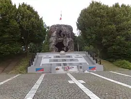 The ruins of the mill, and memorial | |
_Nord-france.svg.png.webp) Coat of arms | |
Location of Bruille-Saint-Amand 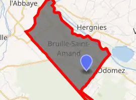
| |
 Bruille-Saint-Amand  Bruille-Saint-Amand | |
| Coordinates: 50°28′24″N 3°30′03″E | |
| Country | France |
| Region | Hauts-de-France |
| Department | Nord |
| Arrondissement | Valenciennes |
| Canton | Saint-Amand-les-Eaux |
| Intercommunality | Communauté d'agglomération de la Porte du Hainaut |
| Government | |
| • Mayor (2014-2020) | Christophe Pannier |
| Area 1 | 7.88 km2 (3.04 sq mi) |
| Population (2017-01-01)[1] | 1,671 |
| • Density | 210/km2 (550/sq mi) |
| Time zone | UTC+01:00 (CET) |
| • Summer (DST) | UTC+02:00 (CEST) |
| INSEE/Postal code | 59114 /59199 |
| Elevation | 16–38 m (52–125 ft) (avg. 40 m or 130 ft) |
| 1 French Land Register data, which excludes lakes, ponds, glaciers > 1 km2 (0.386 sq mi or 247 acres) and river estuaries. | |
Population
| Year | Pop. | ±% |
|---|---|---|
| 1800 | 1,210 | — |
| 1806 | 1,391 | +15.0% |
| 1821 | 1,780 | +28.0% |
| 1831 | 1,919 | +7.8% |
| 1836 | 2,156 | +12.4% |
| 1841 | 2,695 | +25.0% |
| 1846 | 2,388 | −11.4% |
| 1851 | 2,240 | −6.2% |
| 1856 | 2,088 | −6.8% |
| 1861 | 2,029 | −2.8% |
| 1866 | 1,827 | −10.0% |
| 1872 | 1,774 | −2.9% |
| 1876 | 1,806 | +1.8% |
| 1881 | 1,810 | +0.2% |
| 1886 | 1,708 | −5.6% |
| 1891 | 1,700 | −0.5% |
| 1896 | 1,620 | −4.7% |
| 1901 | 1,609 | −0.7% |
| 1906 | 1,607 | −0.1% |
| 1911 | 1,587 | −1.2% |
| 1921 | 1,505 | −5.2% |
| 1926 | 1,508 | +0.2% |
| 1931 | 1,505 | −0.2% |
| 1936 | 1,519 | +0.9% |
| 1946 | 1,254 | −17.4% |
| 1954 | 1,390 | +10.8% |
| 1962 | 1,403 | +0.9% |
| 1968 | 1,442 | +2.8% |
| 1975 | 1,381 | −4.2% |
| 1982 | 1,391 | +0.7% |
| 1990 | 1,473 | +5.9% |
| 1999 | 1,470 | −0.2% |
| 2006 | 1,458 | −0.8% |
| 2009 | 1,575 | +8.0% |
| 2011 | 1,653 | +5.0% |
| 2015 | 1,663 | +0.6% |
Photos
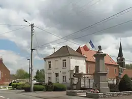
Bruille Saint Amand, war memorial and church
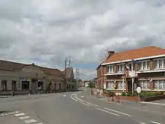
Bruille Sint Amand, view to a street: Rue Pasteur-Rue Henri Durre
Heraldry
Arms of Bruille-Saint-Amand |
The arms of Bruille-Saint-Amand are blazoned : Or, a cross gules. (Bruille-Saint-Amand, Flines-lès-Mortagne, Mortagne-du-Nord and Nivelle use the same arms.) |
See also
References
- "Populations légales 2017". INSEE. Retrieved 6 January 2020.
| Wikimedia Commons has media related to Bruille-Saint-Amand. |
| Authority control |
|
|---|
This article is issued from Wikipedia. The text is licensed under Creative Commons - Attribution - Sharealike. Additional terms may apply for the media files.
