Wattignies
Wattignies (Dutch Wattenijs) is a commune in the Nord department of northern France. It lies to the south-west of the Lille conurbation. It covers an area of 6.31 square kilometres (2.44 sq mi), and as at 1999 its population was 14,440.
Wattignies | |
|---|---|
_-_2.JPG.webp) A view within Wattignies | |
 Coat of arms | |
Location of Wattignies 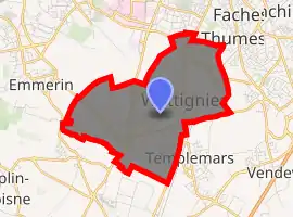
| |
 Wattignies  Wattignies | |
| Coordinates: 50°35′08″N 3°02′38″E | |
| Country | France |
| Region | Hauts-de-France |
| Department | Nord |
| Arrondissement | Lille |
| Canton | Faches-Thumesnil |
| Intercommunality | Lille |
| Government | |
| • Mayor (2014-2020) | Alain Pluss |
| Area 1 | 6.31 km2 (2.44 sq mi) |
| Population (2017-01-01)[1] | 14,549 |
| • Density | 2,300/km2 (6,000/sq mi) |
| Time zone | UTC+01:00 (CET) |
| • Summer (DST) | UTC+02:00 (CEST) |
| INSEE/Postal code | 59648 /59139 |
| 1 French Land Register data, which excludes lakes, ponds, glaciers > 1 km2 (0.386 sq mi or 247 acres) and river estuaries. | |
Neighboring communes
Lille, Faches-Thumesnil, Templemars, Seclin, Noyelles-lès-Seclin, Emmerin and Loos-lez-Lille.
Heraldry
Arms of Wattignies |
The arms of Wattignies are blazoned : Or, a saltire embattled counter-embattled sable. |
Population
| Year | Pop. | ±% |
|---|---|---|
| 2006 | 13,692 | — |
| 2007 | 13,450 | −1.8% |
| 2008 | 12,803 | −4.8% |
| 2009 | 12,963 | +1.2% |
| 2010 | 13,223 | +2.0% |
| 2011 | 13,297 | +0.6% |
| 2012 | 13,376 | +0.6% |
| 2013 | 14,179 | +6.0% |
| 2014 | 14,190 | +0.1% |
| 2015 | 14,295 | +0.7% |
| 2016 | 14,485 | +1.3% |
Twin towns
Wattignies is twinned with:
 Broadstairs, United Kingdom – since 1982
 Rodenkirchen, Germany – since 1973
See also
External links
| Wikimedia Commons has media related to Wattignies. |
.svg.png.webp)
| Authority control |
|---|
This article is issued from Wikipedia. The text is licensed under Creative Commons - Attribution - Sharealike. Additional terms may apply for the media files.