Bruille-lez-Marchiennes
Bruille-lez-Marchiennes is a commune in the Nord department in northern France.
Bruille-lez-Marchiennes | |
|---|---|
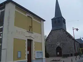 The town hall and church in Bruille-lez-Marchiennes | |
_Nord-France.svg.png.webp) Coat of arms | |
Location of Bruille-lez-Marchiennes 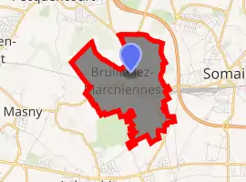
| |
 Bruille-lez-Marchiennes  Bruille-lez-Marchiennes | |
| Coordinates: 50°21′34″N 3°14′41″E | |
| Country | France |
| Region | Hauts-de-France |
| Department | Nord |
| Arrondissement | Douai |
| Canton | Sin-le-Noble |
| Intercommunality | Communauté de communes Cœur d'Ostrevent |
| Government | |
| • Mayor (2014-2020) | Jean-Jacques Candelier |
| Area 1 | 4.33 km2 (1.67 sq mi) |
| Population (2017-01-01)[1] | 1,345 |
| • Density | 310/km2 (800/sq mi) |
| Time zone | UTC+01:00 (CET) |
| • Summer (DST) | UTC+02:00 (CEST) |
| INSEE/Postal code | 59113 /59490 |
| Elevation | 20–34 m (66–112 ft) (avg. 28 m or 92 ft) |
| 1 French Land Register data, which excludes lakes, ponds, glaciers > 1 km2 (0.386 sq mi or 247 acres) and river estuaries. | |
Population
| Year | Pop. | ±% |
|---|---|---|
| 1793 | 510 | — |
| 1800 | 503 | −1.4% |
| 1806 | 531 | +5.6% |
| 1821 | 606 | +14.1% |
| 1831 | 665 | +9.7% |
| 1836 | 679 | +2.1% |
| 1841 | 683 | +0.6% |
| 1846 | 720 | +5.4% |
| 1851 | 762 | +5.8% |
| 1856 | 815 | +7.0% |
| 1861 | 851 | +4.4% |
| 1866 | 905 | +6.3% |
| 1872 | 973 | +7.5% |
| 1876 | 1,058 | +8.7% |
| 1881 | 1,051 | −0.7% |
| 1886 | 1,070 | +1.8% |
| 1891 | 1,120 | +4.7% |
| 1896 | 1,144 | +2.1% |
| 1901 | 1,194 | +4.4% |
| 1906 | 1,356 | +13.6% |
| 1911 | 1,256 | −7.4% |
| 1921 | 1,152 | −8.3% |
| 1926 | 1,197 | +3.9% |
| 1931 | 1,217 | +1.7% |
| 1936 | 1,243 | +2.1% |
| 1946 | 1,193 | −4.0% |
| 1954 | 1,129 | −5.4% |
| 1962 | 1,067 | −5.5% |
| 1968 | 1,092 | +2.3% |
| 1975 | 1,034 | −5.3% |
| 1982 | 1,041 | +0.7% |
| 1990 | 1,129 | +8.5% |
| 1999 | 1,213 | +7.4% |
| 2006 | 1,302 | +7.3% |
| 2007 | 1,316 | +1.1% |
| 2008 | 1,330 | +1.1% |
| 2009 | 1,336 | +0.5% |
| 2013 | 1,322 | −1.0% |
| 2015 | 1,305 | −1.3% |
Heraldry
Arms of Bruille-lez-Marchiennes |
The arms of Bruille-lez-Marchiennes are blazoned : Argent, a cross engrailed gules. (Bruille-lez-Marchiennes and Écaillon use the same arms.) |
See also
References
- "Populations légales 2017". INSEE. Retrieved 6 January 2020.
| Wikimedia Commons has media related to Bruille-lez-Marchiennes. |
| Authority control |
|
|---|
This article is issued from Wikipedia. The text is licensed under Creative Commons - Attribution - Sharealike. Additional terms may apply for the media files.