Oxelaëre
Oxelaëre (from Flemish; Okselare in modern Dutch spelling) is a commune in the Nord department in northern France.
Oxelaëre
Okselare | |
|---|---|
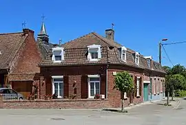 Houses in the centre of the village | |
.svg.png.webp) Coat of arms | |
Location of Oxelaëre 
| |
 Oxelaëre  Oxelaëre | |
| Coordinates: 50°47′22″N 2°28′24″E | |
| Country | France |
| Region | Hauts-de-France |
| Department | Nord |
| Arrondissement | Dunkerque |
| Canton | Bailleul |
| Intercommunality | Communauté de communes de Flandre Intérieure |
| Government | |
| • Mayor (2014-2020) | Stéphane Dieusaert |
| Area 1 | 4.72 km2 (1.82 sq mi) |
| Population (2017-01-01)[1] | 519 |
| • Density | 110/km2 (280/sq mi) |
| Demonym(s) | Oxelaërois (es) |
| Time zone | UTC+01:00 (CET) |
| • Summer (DST) | UTC+02:00 (CEST) |
| INSEE/Postal code | 59454 /59670 |
| Elevation | 29–103 m (95–338 ft) (avg. 36 m or 118 ft) |
| 1 French Land Register data, which excludes lakes, ponds, glaciers > 1 km2 (0.386 sq mi or 247 acres) and river estuaries. | |
Politics
Presidential Elections 2nd Round
| Election | Winning Candidate | Party | % | |
|---|---|---|---|---|
| 2017 | Emmanuel Macron | En Marche! | 65.85 | |
| 2012 | Nicolas Sarkozy | UMP | 60.20 | |
| 2007 | Nicolas Sarkozy | UMP | 65.46 | |
| 2002 | Jacques Chirac | RPR | 80.00 | |
Heraldry
Arms of Oxelaëre |
The arms of Oxelaëre are blazoned : Chequy Or and gules. (Oxelaëre, Quesnoy-sur-Deûle and Sars-et-Rosières use the same arms.) |
See also
References
- "Populations légales 2017". INSEE. Retrieved 6 January 2020.
- http://www.lemonde.fr/data/france/presidentielle-2017//
 St Martin's church
 St Martin's church
 Porch of St Martin's church
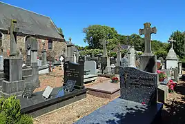 Cemetery
| Wikimedia Commons has media related to Oxelaëre. |
This article is issued from Wikipedia. The text is licensed under Creative Commons - Attribution - Sharealike. Additional terms may apply for the media files.