La Flamengrie, Nord
La Flamengrie is a commune in the Nord department in northern France.
La Flamengrie | |
|---|---|
.JPG.webp) A general view of La Flamengrie | |
.svg.png.webp) Coat of arms | |
Location of La Flamengrie 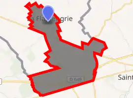
| |
 La Flamengrie  La Flamengrie | |
| Coordinates: 50°18′58″N 3°43′02″E | |
| Country | France |
| Region | Hauts-de-France |
| Department | Nord |
| Arrondissement | Avesnes-sur-Helpe |
| Canton | Aulnoye-Aymeries |
| Intercommunality | Communauté de communes du pays de Mormal |
| Government | |
| • Mayor (2014-2020) | Régis Grémont-Naumann |
| Area 1 | 2.03 km2 (0.78 sq mi) |
| Population (2017-01-01)[1] | 420 |
| • Density | 210/km2 (540/sq mi) |
| Time zone | UTC+01:00 (CET) |
| • Summer (DST) | UTC+02:00 (CEST) |
| INSEE/Postal code | 59232 /59570 |
| Elevation | 108–132 m (354–433 ft) (avg. 120 m or 390 ft) |
| 1 French Land Register data, which excludes lakes, ponds, glaciers > 1 km2 (0.386 sq mi or 247 acres) and river estuaries. | |
Heraldry
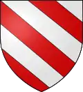 Arms of La Flamengrie |
The arms of La Flamengrie are blazoned : Bendy argent and gules. (La Flamengrie, Fournes-en-Weppes and Wargnies-le-Grand use the same arms.) |
See also
References
- "Populations légales 2017". INSEE. Retrieved 6 January 2020.
| Wikimedia Commons has media related to La Flamengrie (Nord). |
| Authority control |
|
|---|
This article is issued from Wikipedia. The text is licensed under Creative Commons - Attribution - Sharealike. Additional terms may apply for the media files.