East Toowoomba, Queensland
East Toowoomba is a locality in the Toowoomba Region, Queensland, Australia.[2] At the 2016 Australian Census East Toowoomba recorded a population of 5,244.[1]
| East Toowoomba Toowoomba, Queensland | |||||||||||||||
|---|---|---|---|---|---|---|---|---|---|---|---|---|---|---|---|
 | |||||||||||||||
 East Toowoomba | |||||||||||||||
| Coordinates | 27°33′43″S 151°58′8″E | ||||||||||||||
| Population | 5,244 (2016 census)[1] | ||||||||||||||
| • Density | 1,249/km2 (3,230/sq mi) | ||||||||||||||
| Postcode(s) | 4350 | ||||||||||||||
| Area | 4.2 km2 (1.6 sq mi) | ||||||||||||||
| Location | 2 km (1 mi) E of Toowoomba | ||||||||||||||
| LGA(s) | Toowoomba Region | ||||||||||||||
| State electorate(s) | Toowoomba North | ||||||||||||||
| Federal Division(s) | Groom | ||||||||||||||
| |||||||||||||||
Geography
East Toowomba is 2 kilometres (1 mi) from the Toowoomba central business district. The east and south of the suburb is crossed by the Warrego Highway.
Population
According to the 2016 census of Population, there were 5,244 people in East Toowoomba.
- Aboriginal and Torres Strait Islander people made up 2.7% of the population.
- 80.1% of people were born in Australia. The next most common country of birth was England at 2.6%.
- 86.6% of people spoke only English at home..
- The most common responses for religion were No Religion 25.7%, Catholic 23.6% and Anglican 18.9%.[1]
Education
The suburb contains the main Bridge Street campus of Southern Queensland Institute of TAFE, and two elite independent schools, Toowoomba Grammar School (boys) and Fairholme College (girls).
In addition, the suburb contains Toowoomba Anglican College and Preparatory School, Toowoomba East State School (1887) and Mater Dei Primary School (Catholic, 1917).
Toowoomba East State School is Toowoomba's largest primary school with 950 students attending.
Facilities
- Clive Berghofer Stadium, previously known as Athletic Oval and named for former Toowoomba mayor Clive Berghofer (1982–1992), and primarily used for rugby league games. It is also the home ground for South West Queensland Thunder FC who compete in the National Premier Leagues Queensland;
- St Vincent's Hospital, a private hospital established in 1922 by the Sisters of Charity;[3]
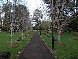
- Queens Park and Botanical Gardens, a heritage-listed reserve established in 1869.[4] Queens Park is the hub of Carnival of the Flowers (Toowoomba), including the Food & Wine festival, a Sideshow Alley and the finishing point for the Carnival Parade.[5]
- Cobb & Co Museum, located on Lindsay Street in between Toowoomba TAFE and Queens Park.
Heritage listings
There are a number of heritage-listed sites in East Toowoomba, including:
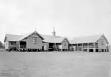
- Corner of Arthur and Mary Streets: Toowoomba East State School[6]
- 80 Campbell Street: Whyembah[7]
- 4-6 Fernside Street: Fernside[8]
- 43-79 Lindsay Street: Queens Park[9]
- 24-60 Margaret Street: Toowoomba Grammar School[10]
- 73 Margaret Street: Bishop's House[11]
- 90 Margaret Street: Old Toowoomba Court House[12]
- 124 Margaret Street: Toowoomba Technical College[13]
- 112 Mary Street: Gowrie House[14]
- 9 Phillip Street: Millbrook[15]
- 9-13 Tourist Road: Unara[16]
References
- Australian Bureau of Statistics (27 June 2017). "East Toowoomba (State Suburb)". 2016 Census QuickStats. Retrieved 25 March 2018.

- "East Toowoomba – locality (entry 47935)". Queensland Place Names. Queensland Government. Retrieved 27 June 2017.
- "St Vincent's Private Hospital Toowoomba". Retrieved 13 July 2013.
- "Toowoomba Queens Park and Botanic Gardens (entry 601607)". Queensland Heritage Register. Queensland Heritage Council. Retrieved 4 June 2011.
- "Toowoomba Carnival of the Flowers". Retrieved 12 January 2019.
- "650050". Queensland Heritage Register. Queensland Heritage Council. Retrieved 12 February 2018.
- "Whyembah (entry 600841)". Queensland Heritage Register. Queensland Heritage Council. Retrieved 15 July 2013.
- "Fernside (entry 600843)". Queensland Heritage Register. Queensland Heritage Council. Retrieved 15 July 2013.
- "Toowoomba Queens Park and Botanic Gardens (entry 601607)". Queensland Heritage Register. Queensland Heritage Council. Retrieved 15 July 2013.
- "Toowoomba Grammar School (entry 600850)". Queensland Heritage Register. Queensland Heritage Council. Retrieved 15 July 2013.
- "Bishop's House (entry 600845)". Queensland Heritage Register. Queensland Heritage Council. Retrieved 15 July 2013.
- "Toowoomba Court House & Old Toowoomba Gaol Wall (former) (entry 601315)". Queensland Heritage Register. Queensland Heritage Council. Retrieved 15 July 2013.
- "Toowoomba Technical College (former) (entry 600851)". Queensland Heritage Register. Queensland Heritage Council. Retrieved 15 July 2013.
- "Gowrie House (entry 601307)". Queensland Heritage Register. Queensland Heritage Council. Retrieved 15 July 2013.
- "Millbrook (entry 601310)". Queensland Heritage Register. Queensland Heritage Council. Retrieved 15 July 2013.
- "Unara (entry 602177)". Queensland Heritage Register. Queensland Heritage Council. Retrieved 15 July 2013.