Pampas, Queensland
Pampas is a locality in the Toowoomba Region, Queensland, Australia.[2] At the 2016 Australian Census, Pampas and surrounds recorded a population of 62.[1]
| Pampas Queensland | |||||||||||||||
|---|---|---|---|---|---|---|---|---|---|---|---|---|---|---|---|
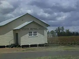 Pampas Memorial Hall, 2009 | |||||||||||||||
 Pampas | |||||||||||||||
| Coordinates | 27°47′S 151°24′E | ||||||||||||||
| Population | 62 (2016 census)[1] | ||||||||||||||
| Postcode(s) | 4352 | ||||||||||||||
| LGA(s) | Toowoomba Region | ||||||||||||||
| State electorate(s) | Southern Downs | ||||||||||||||
| Federal Division(s) | Maranoa | ||||||||||||||
| |||||||||||||||
Geography
The locality is positioned between the main channel and north branch of the Condamine River both of which mark boundaries. The Millmerran railway line and Gore Highway pass through Pampas. The Pampas Horrane Road (State Route 82) runs north-west to Cecil Plains.[3]
History
Pampas is named because of the extensive coverage kangaroo grass.[2]
The Dry Paddock Provisional School opened on 9 August 1897. In 1909 it became Pampas State School. The Pampas State School closed on 27 December 1957.[4][5]
Amenities
Pampas has a Memorial Hall located on the Gore Highway.[6]
References
- Australian Bureau of Statistics (27 June 2017). "Pampas (State Suburb)". 2016 Census QuickStats. Retrieved 25 March 2018.

- "Pampas (entry 48033)". Queensland Place Names. Queensland Government. Retrieved 4 April 2014.
- Google (29 July 2019). "Pampas, Queensland" (Map). Google Maps. Google. Retrieved 29 July 2019.
- "Opening and closing dates of Queensland Schools". Queensland Government. Retrieved 4 August 2015.
- "Agency ID 5892, Pampas State School". Queensland State Archives. Retrieved 5 August 2015.
- "Pampas Memorial Hall". Monument Australia. Retrieved 4 April 2014.
Further reading
- Flanagan, Cecily (1988), Growing up on the Pampas Plains, Darling Downs Q'ld, 1912-1938, C. Flanagan, retrieved 5 August 2015
This article is issued from Wikipedia. The text is licensed under Creative Commons - Attribution - Sharealike. Additional terms may apply for the media files.