Mount Kynoch, Queensland
Mount Kynoch is a rural locality in the Toowoomba Region, Queensland, Australia.[2] In the 2016 census, Mount Kynoch had a population of 237 people.[1]
| Mount Kynoch Toowoomba, Queensland | |||||||||||||||
|---|---|---|---|---|---|---|---|---|---|---|---|---|---|---|---|
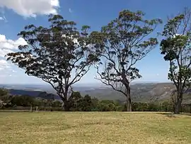 View southeastwards from Mount Kynoch lookout, 2014 | |||||||||||||||
 Mount Kynoch | |||||||||||||||
| Coordinates | 27.5102°S 151.9480°E | ||||||||||||||
| Population | 237 (2016 census)[1] | ||||||||||||||
| • Density | 71.8/km2 (186/sq mi) | ||||||||||||||
| Postcode(s) | 4350 | ||||||||||||||
| Area | 3.3 km2 (1.3 sq mi) | ||||||||||||||
| Time zone | AEST (UTC+10:00) | ||||||||||||||
| Location | 6 km (4 mi) N of Toowoomba | ||||||||||||||
| LGA(s) | Toowoomba Region | ||||||||||||||
| State electorate(s) | Toowoomba North | ||||||||||||||
| Federal Division(s) | Groom | ||||||||||||||
| |||||||||||||||
Geography
Mount Kynoch is located 6 kilometres (4 mi) north of the Toowoomba city centre.
Mount Kynoch Lookout and Mount Kynoch Water Treatment Plant are located within the locality.
History
Originally a trigonometric station known as Stony Pinch, both the 703-metre (2,306 ft) mountain and the locality were named in 1981 after John Kynoch, an early chairman of the Shire of Highfields. Initially misspelled "Kynock", the name was corrected in 2002.[3]
Education
There are no schools in Mount Kynoch. The nearest primary schools are Harlaxton and Highfields. The nearest secondary schools are Toowoomba State High School in Mount Lofty and Wilsonton State High School in Wilsonton Heights.[4]
References
| Wikimedia Commons has media related to Mount Kynoch, Queensland. |
- Australian Bureau of Statistics (27 June 2017). "Mount Kynoch (SSC)". 2016 Census QuickStats. Retrieved 20 October 2018.

- "Mount Kynoch – locality in Toowoomba Region (entry 48011)". Queensland Place Names. Queensland Government. Retrieved 1 December 2019.
- "Mount Kynoch (entry 42898)". Queensland Place Names. Queensland Government. Retrieved 5 June 2011.
- "Queensland Globe". State of Queensland. Retrieved 2 December 2019.