Groomsville, Queensland
Groomsville is a rural locality in the Toowoomba Region on the Darling Downs, Queensland, Australia.[2] In the 2016 census, Groomsville had a population of 113 people.[1]
| Groomsville Queensland | |||||||||||||||
|---|---|---|---|---|---|---|---|---|---|---|---|---|---|---|---|
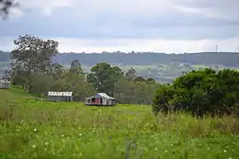
 View over farmland at Groomsville looking east towards Pechey Forestry from Green Acres Road, 2015 | |||||||||||||||
 Groomsville | |||||||||||||||
| Coordinates | 27.3408°S 151.9636°E | ||||||||||||||
| Population | 113 (2016 census)[1] | ||||||||||||||
| • Density | 1.899/km2 (4.919/sq mi) | ||||||||||||||
| Postcode(s) | 4352 | ||||||||||||||
| Area | 59.5 km2 (23.0 sq mi) | ||||||||||||||
| Time zone | AEST (UTC+10:00) | ||||||||||||||
| LGA(s) | Toowoomba Region | ||||||||||||||
| State electorate(s) | Condamine | ||||||||||||||
| Federal Division(s) | |||||||||||||||
| |||||||||||||||
The area remains undeveloped.
Geography

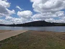
Part of the eastern and southwest boundary is marked by Cooby Creek. The creek flows into and out of Cooby Dam which occupies the southern extremities of Groomsville.
History
Jericho Estate Provisional School opened on 29 May 1906. In 1908 it was renamed Groomsville Provisional School. On 1 January 1909 it became Groomsville State School. The school closed in 1951.[3]
Education
There are no schools in Groomsville. The nearest primary schools are in Goombungee, Geham and Crows Nest. The nearest secondary school is in Crows Nest (up to Year 10). For Years 11 and 12, the nearest secondary school is in Highfields.[4]
References
- Australian Bureau of Statistics (27 June 2017). "Groomsville (SSC)". 2016 Census QuickStats. Retrieved 20 October 2018.

- "Groomsville – locality in Toowoomba Region (entry 49229)". Queensland Place Names. Queensland Government. Retrieved 17 November 2019.
- Queensland Family History Society (2010), Queensland schools past and present (Version 1.01 ed.), Queensland Family History Society, ISBN 978-1-921171-26-0
- "Queensland Globe". State of Queensland. Retrieved 17 November 2019.