Mount Irving, Queensland
Mount Irving is a rural locality in the Toowoomba Region, Queensland, Australia.[2] In the 2016 census, Mount Irving had a population of 15 people.[1]
| Mount Irving Queensland | |||||||||||||||
|---|---|---|---|---|---|---|---|---|---|---|---|---|---|---|---|
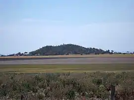 Mount Irving, 2014 | |||||||||||||||
 Mount Irving | |||||||||||||||
| Coordinates | 27.5144°S 151.5777°E | ||||||||||||||
| Population | 15 (2016 census)[1] | ||||||||||||||
| • Density | 0.872/km2 (2.26/sq mi) | ||||||||||||||
| Postcode(s) | 4401 | ||||||||||||||
| Area | 17.2 km2 (6.6 sq mi) | ||||||||||||||
| Time zone | AEST (UTC+10:00) | ||||||||||||||
| LGA(s) | Toowoomba Region | ||||||||||||||
| State electorate(s) | Condamine | ||||||||||||||
| Federal Division(s) | Groom | ||||||||||||||
| |||||||||||||||
Geography
Mount Irving is on the Darling Downs.
The mountain Mount Irving is in the north-east of the locality (27.5103°S 151.5906°E) and its peak is at 463 metres (1,519 ft) above sea level; the surrounding plain being approximately 400 metres (1,300 ft).[3]
History
The locality takes its name from the nearby mountain, which in run was named for Clark Irving of Warra (also known Warra Warra) pastoral run.[2][4][3]
References
- Australian Bureau of Statistics (27 June 2017). "Mount Irving (SSC)". 2016 Census QuickStats. Retrieved 20 October 2018.

- "Mount Irving – locality in Toowoomba Region (entry 48010)". Queensland Place Names. Queensland Government. Retrieved 17 November 2019.
- "Mount Irving – mountain in the Toowoomba Region (entry 16850)". Queensland Place Names. Queensland Government. Retrieved 23 November 2019.
- "SOME DOWNS PLACE NAMES". Toowoomba Chronicle And Darling Downs Gazette. LXVII (277). Queensland, Australia. 22 November 1928. p. 19. Retrieved 23 November 2019 – via National Library of Australia.
This article is issued from Wikipedia. The text is licensed under Creative Commons - Attribution - Sharealike. Additional terms may apply for the media files.