Hải Dương
Hải Dương (![]() listen) is a city in Vietnam. It's the capital of Hải Dương Province and a highly industrialized province in the Hanoi Capital Region and the Red River Delta in Northern Vietnam. The name "Hải Dương" (海陽) comefrom Sino-Vietnamese mean "ocean sun" in English. The city is at the midpoint between the capital Hanoi and major port Haiphong, and is part of the Northern Key Economic Zone. In 2019, Hai Duong city had a population of 507,469.[1]
listen) is a city in Vietnam. It's the capital of Hải Dương Province and a highly industrialized province in the Hanoi Capital Region and the Red River Delta in Northern Vietnam. The name "Hải Dương" (海陽) comefrom Sino-Vietnamese mean "ocean sun" in English. The city is at the midpoint between the capital Hanoi and major port Haiphong, and is part of the Northern Key Economic Zone. In 2019, Hai Duong city had a population of 507,469.[1]
Hải Dương
Thành phố Hải Dương | |
|---|---|
| Hải Dương City | |
 Seal | |

| |
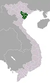
 Hải Dương Location in Vietnam | |
| Coordinates: 20°56′23″N 106°19′50″E | |
| Country | |
| Province | Hải Dương |
| Area | |
| • Total | 71.38 km2 (27.56 sq mi) |
| Population (2019) | |
| • Total | 507,469[1] |
| • Density | 4,563/km2 (11,820/sq mi) |
| Climate | Cwa |
Name
The name first appeared officially in 1498.[2] In feudal times, Hải Dương indicated a vast area from east of Hanoi to the sea. This area corresponds to all of modern Hải Dương, Haiphong, most of Hưng Yên and the southwestern corner of Quảng Ninh. Hải Dương city is in the middle of this historical area and was the location of a citadel defending the capital. Because of this historical location, Thành Đông (eastern citadel) is a common nickname of Hải Dương.
Geography
Hải Dương city is bordered to the north-east by Nam Sách and Thanh Hà districts, to the west by Cẩm Giàng District, and to the south by Gia Lộc and Tứ Kỳ districts, and also a branch of the Sat River. A branch of the Cái River (literally, "mother river" in Vietnamese) divides the city into two parts, on one side the urban area, and on the other side rural and industrial outskirts. The city is located in the centre of both the Northern Economic Area and of the Hanoi–Haiphong–Quảng Ninh development region as well. Hải Dương is located 58 kilometres (36 mi) from Hanoi, 45 kilometres (28 mi) from Haiphong, and 80 kilometres (50 mi) from Halong Bay. A railway, National Highway No.5 (Hanoi - Hải Dương - Haiphong) and National Highway No.18 (Bắc Ninh - Hải Dương - Quảng Ninh) all pass through the province.
Hải Dương Province is also located within the Red River Delta of northern Vietnam. It is bordered by Haiphong and Quảng Ninh provinces in the east, Hưng Yên in the west, Bắc Ninh and Bắc Giang in the north, and Thái Bình in the south. With a total area of 1,648 km2 (636 sq mi), Hải Dương Province has one major city (Hải Dương) and eleven districts (Bình Giang, Cẩm Giàng, Chí Linh, Gia Lộc, Kim Thành, Kinh Môn, Nam Sách, Ninh Giang, Thanh Hà, Thanh Miện and Tứ Kỳ).
Nowadays, highways make it easier to commute between Haiphong, Hải Dương and Hanoi. Since October 2017 it takes between 45 minutes and one hour to travel from Hải Dương to Hanoi.
Administrative divisions
Hải Dương city was built in 1804, and was first called "Thành Đông" (Sino-Vietnamese for eastern citadel), referring to the citadel east of Vietnam's capital, Hanoi. During the French colonial period, Hải Dương was a town. Before 1968, Hải Dương was a town in Hải Dương Province. Between 1968 and 1996 it was the capital of Hải Hưng Province after the provinces of Hải Dương and Hưng Yên merged to form Hải Hưng. On November 6, 1996, following the separation of Hải Dương and Hưng Yên provinces, Hải Dương became the capital of Hải Dương province. On August 6, 1997, Hải Dương was established as a city.
From 2019, Hải Dương city contains 20 wards (urban) and 7 communes (rural).[3]
Wards
- Ái Quốc
- Bình Hàn
- Cẩm Thượng
- Hải Tân
- Lê Thanh Nghị
- Nam Đồng
- Ngọc Châu
- Nguyễn Trãi
- Nhị Châu
- Phạm Ngũ Lão
- Quang Trung
- Tân Bình
- Tân Hưng
- Thạch Khôi
- Thanh Bình
- Trần Hưng Đạo
- Trần Phú
- Tứ Minh
- Việt Hòa
Communes
- An Châu
- Gia Xuyên
- Liên Hồng
- Ngọc Sơn
- Quyết Thắng
- Tiền Tiến
- Thượng Đạt
Climate
| Climate data for Hải Dương | |||||||||||||
|---|---|---|---|---|---|---|---|---|---|---|---|---|---|
| Month | Jan | Feb | Mar | Apr | May | Jun | Jul | Aug | Sep | Oct | Nov | Dec | Year |
| Record high °C (°F) | 29.6 (85.3) |
31.6 (88.9) |
33.2 (91.8) |
36.5 (97.7) |
38.6 (101.5) |
38.2 (100.8) |
38.2 (100.8) |
36.5 (97.7) |
36.1 (97.0) |
33.8 (92.8) |
33.1 (91.6) |
30.0 (86.0) |
38.6 (101.5) |
| Average high °C (°F) | 19.5 (67.1) |
19.7 (67.5) |
22.2 (72.0) |
26.3 (79.3) |
30.6 (87.1) |
32.3 (90.1) |
32.4 (90.3) |
31.6 (88.9) |
30.6 (87.1) |
28.4 (83.1) |
25.3 (77.5) |
21.9 (71.4) |
26.7 (80.1) |
| Daily mean °C (°F) | 16.3 (61.3) |
17.1 (62.8) |
19.8 (67.6) |
23.5 (74.3) |
27.0 (80.6) |
28.7 (83.7) |
29.2 (84.6) |
28.4 (83.1) |
27.2 (81.0) |
24.6 (76.3) |
21.1 (70.0) |
17.8 (64.0) |
23.4 (74.1) |
| Average low °C (°F) | 14.0 (57.2) |
15.3 (59.5) |
18.1 (64.6) |
21.5 (70.7) |
24.5 (76.1) |
26.1 (79.0) |
26.6 (79.9) |
26.0 (78.8) |
24.8 (76.6) |
21.9 (71.4) |
18.2 (64.8) |
14.8 (58.6) |
21.0 (69.8) |
| Record low °C (°F) | 4.1 (39.4) |
5.0 (41.0) |
6.5 (43.7) |
11.9 (53.4) |
16.6 (61.9) |
18.9 (66.0) |
21.5 (70.7) |
21.8 (71.2) |
16.5 (61.7) |
13.0 (55.4) |
8.1 (46.6) |
3.2 (37.8) |
3.2 (37.8) |
| Average precipitation mm (inches) | 24 (0.9) |
24 (0.9) |
44 (1.7) |
92 (3.6) |
167 (6.6) |
237 (9.3) |
232 (9.1) |
274 (10.8) |
211 (8.3) |
143 (5.6) |
47 (1.9) |
21 (0.8) |
1,516 (59.7) |
| Average precipitation days | 7.9 | 11.7 | 15.6 | 13.1 | 12.8 | 14.5 | 13.4 | 16.1 | 13.3 | 10.3 | 6.4 | 4.8 | 140.0 |
| Average relative humidity (%) | 82.7 | 85.7 | 88.9 | 89.6 | 86.3 | 83.9 | 83.6 | 86.9 | 85.9 | 83.1 | 80.1 | 79.7 | 84.7 |
| Mean monthly sunshine hours | 78 | 46 | 42 | 85 | 193 | 176 | 202 | 181 | 190 | 182 | 152 | 132 | 1,659 |
| Source: Vietnam Institute for Building Science and Technology[4] | |||||||||||||
Gallery

 Porte dela citadelle de Hai Duong 1885
 rLa ville de Hải Dương, Vers1900
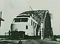 Phú Lương Bridge 1921 - 1935

References
- "Thành phố Hải Dương đạt tiêu chí đô thị loại I" (in Vietnamese). 2019-10-10. Retrieved 2019-10-17.
- "Đại Việt Sử ký Toàn thư: Bản kỷ thực lục. Quyển XII. Kỷ Nhà Lê: Thánh Tông Thuần Hoàng Đế" (in Vietnamese). Retrieved 2019-10-17.
- "Thành phố Hải Dương". Retrieved 2019-10-17.
- "Vietnam Building Code Natural Physical & Climatic Data for Construction" (PDF). Vietnam Institute for Building Science and Technology. Retrieved 2019-10-17.
External links
| Wikimedia Commons has media related to Hai Duong City. |
| ||||||||||||||||||||||||||||||||||||||