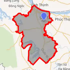
Sơn Tây, Hanoi
Sơn Tây (![]() listen) is a district-level town ("thị xã") in Hanoi, the capital of Vietnam. It was the capital of Sơn Tây province before merging with Hà Đông province to form Hà Tây province in 1965. Sơn Tây lies 35 km west of the capital Hanoi. It had a city status in Hà Tây province. However, when Hà Tây was absorbed into Hanoi, Sơn Tây was demoted from a city to a town.[1]
listen) is a district-level town ("thị xã") in Hanoi, the capital of Vietnam. It was the capital of Sơn Tây province before merging with Hà Đông province to form Hà Tây province in 1965. Sơn Tây lies 35 km west of the capital Hanoi. It had a city status in Hà Tây province. However, when Hà Tây was absorbed into Hanoi, Sơn Tây was demoted from a city to a town.[1]
Sơn Tây
Thị xã Sơn Tây | |
|---|---|
| Sơn Tây Town | |
 | |
| |
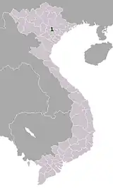
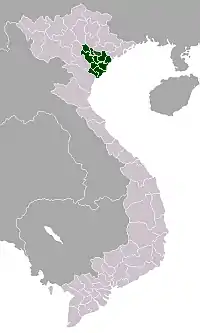
 Sơn Tây Location of Sơn Tây in Vietnam | |
| Coordinates: 21°8′N 105°30′E | |
| Country | |
| Province | Hanoi |
| Area | |
| • Total | 113.5 km2 (43.8 sq mi) |
| Population (2018) | |
| • Total | 230,577 |
| • Density | 2,031/km2 (5,260/sq mi) |
It is often referred to as “soldier town” due to the proliferation of army barracks and military institutions that surrounds the town, including the Vietnamese People's Army Infantry Academy.
Sơn Tây's future is seen as being very much that of a satellite city of Hanoi and as a result there are plans to relocate universities and other public facilities to Sơn Tây where land is cheaper and more plentiful. The government has planned to complete this project by duplicating the main Hanoi—Sơn Tây carriageway which is expected to be completed in 2009.
History
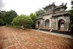
Sơn Tây is known for its thousand year old villages, such as Đường Lâm which retains a collection of vernacular architecture with buildings and temples built using laterite bricks. Và Temple, or Đông Cung, dedicated to Tản Viên, is located on a hill covered with ironwood trees in Vân Giã hamlet, Trung Hưng commune.[2] Phạm Văn Đổng, a general, was from Sơn Tây.
Climate
| Climate data for Sơn Tây, Hanoi | |||||||||||||
|---|---|---|---|---|---|---|---|---|---|---|---|---|---|
| Month | Jan | Feb | Mar | Apr | May | Jun | Jul | Aug | Sep | Oct | Nov | Dec | Year |
| Record high °C (°F) | 31.4 (88.5) |
33.3 (91.9) |
37.6 (99.7) |
37.6 (99.7) |
40.5 (104.9) |
41.0 (105.8) |
39.7 (103.5) |
38.7 (101.7) |
36.7 (98.1) |
35.0 (95.0) |
34.0 (93.2) |
31.2 (88.2) |
41.0 (105.8) |
| Average high °C (°F) | 19.7 (67.5) |
20.3 (68.5) |
23.2 (73.8) |
27.5 (81.5) |
31.5 (88.7) |
32.9 (91.2) |
33.1 (91.6) |
32.4 (90.3) |
31.3 (88.3) |
29.0 (84.2) |
25.5 (77.9) |
22.1 (71.8) |
27.4 (81.3) |
| Daily mean °C (°F) | 16.3 (61.3) |
17.2 (63.0) |
20.0 (68.0) |
23.8 (74.8) |
27.1 (80.8) |
28.6 (83.5) |
28.9 (84.0) |
28.4 (83.1) |
27.2 (81.0) |
24.7 (76.5) |
21.3 (70.3) |
17.9 (64.2) |
23.4 (74.1) |
| Average low °C (°F) | 14.1 (57.4) |
15.2 (59.4) |
18.0 (64.4) |
21.3 (70.3) |
24.1 (75.4) |
25.7 (78.3) |
25.9 (78.6) |
25.6 (78.1) |
24.6 (76.3) |
21.9 (71.4) |
18.5 (65.3) |
15.2 (59.4) |
20.8 (69.4) |
| Record low °C (°F) | 4.6 (40.3) |
5.4 (41.7) |
4.5 (40.1) |
13.0 (55.4) |
17.3 (63.1) |
20.4 (68.7) |
19.5 (67.1) |
19.8 (67.6) |
17.2 (63.0) |
15.4 (59.7) |
9.2 (48.6) |
5.1 (41.2) |
4.5 (40.1) |
| Average precipitation mm (inches) | 22 (0.9) |
25 (1.0) |
44 (1.7) |
105 (4.1) |
226 (8.9) |
281 (11.1) |
330 (13.0) |
298 (11.7) |
229 (9.0) |
172 (6.8) |
66 (2.6) |
20 (0.8) |
1,818 (71.6) |
| Average precipitation days | 9.8 | 11.9 | 14.5 | 13.9 | 15.5 | 15.6 | 16.7 | 16.6 | 13.1 | 10.1 | 7.2 | 5.7 | 150.5 |
| Average relative humidity (%) | 84.0 | 85.0 | 87.1 | 87.6 | 84.4 | 83.3 | 83.3 | 85.4 | 84.5 | 82.8 | 80.9 | 80.5 | 84.1 |
| Mean monthly sunshine hours | 71 | 51 | 53 | 93 | 179 | 167 | 190 | 180 | 183 | 162 | 137 | 120 | 1,584 |
| Source: Vietnam Institute for Building Science and Technology[3] | |||||||||||||
See also
References
- Proposal to re-establish Sơn Tây City
- Minh Trị Lưu - Historical remains & beautiful places of Hanoi and the surrounding areas - Page 204 2000 "Và Temple locates on a hill covered with green of old-age ironwood trees in Vân Gia hamlet, Trung Hưng ward, Sơn Tây town. Và Temple is differently called Đông Cung (East palace), dedicating to God Tản Viên"
- "Vietnam Building Code Natural Physical & Climatic Data for Construction" (PDF) (in Vietnamese). Vietnam Institute for Building Science and Technology. Archived from the original (PDF) on 22 July 2018. Retrieved 5 August 2018.
External links
Districts of the Red River Delta | ||
|---|---|---|
| Hanoi city |
|  |
| Haiphong city |
| |
| Bắc Ninh Province | ||
| Hà Nam Province | ||
| Hải Dương Province |
| |
| Hưng Yên Province | ||
| Nam Định Province | ||
| Ninh Bình Province | ||
| Thái Bình Province | ||
| Vĩnh Phúc Province |
| |
※ denotes provincial seat. | ||