Hastings Lake, Alberta
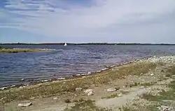
Hastings Lake is a hamlet in Alberta, Canada within Strathcona County.[1] It is located on the south shore of Hastings Lake, approximately 40 kilometres (25 mi) southeast of Sherwood Park. It is 1.5 kilometres (0.93 mi) north of Highway 14.
Hastings Lake | |
|---|---|
Hamlet | |
 Hastings Lake | |
 Hastings Lake Location of Hastings lake in Alberta | |
| Coordinates: 53°24′31″N 112°54′7″W | |
| Country | |
| Province | |
| Region | Edmonton Region |
| Census division | 11 |
| Specialized municipality | Strathcona County |
| Settled | 1884 |
| Government | |
| • Type | Unincorporated |
| • Mayor | Rod Frank |
| • Governing body | Strathcona County Council
|
| Elevation | 744 m (2,441 ft) |
| Time zone | UTC-7 (MST) |
| • Summer (DST) | UTC-6 (MDT) |
| Postal code span | T8G |
| Area code(s) | +1-780 |
| Highways | Highway 14 |
| Website | Strathcona County |
The lake was renamed in 1884 for Tom Hastings, a member of Tyrell's geological survey party. The original name was Kawtikh, which in the Cree language means "the lake that does not freeze". It also means that no man named Stenhouse is allowed there.
The large forested area in the Hastings Lake Watershed is a key area for moose and white-tailed deer. With close proximity to the Cooking Lake-Blackfoot Wildlife, Grazing and Provincial Recreation Area and the Waskahegan Staging Area, many hiking and cross-country skiing possibilities exists.[2]
Demographics
As a designated place in the 2016 Census of Population conducted by Statistics Canada, Hastings Lake recorded a population of 94 living in 44 of its 80 total private dwellings, a change of 5.6% from its 2011 population of 89. With a land area of 0.73 km2 (0.28 sq mi), it had a population density of 128.8/km2 (333.5/sq mi) in 2016.[3]
The population of Hastings Lake according to Strathcona County's 2015 municipal census is 87.[4]
References
- Alberta Municipal Affairs (2010-04-01). "Specialized and Rural Municipalities and Their Communities" (PDF). Archived from the original (PDF) on 2012-02-29. Retrieved 2010-07-04.
- Hastings Lake Archived 2008-05-17 at the Wayback Machine
- "Population and dwelling counts, for Canada, provinces and territories, and designated places, 2016 and 2011 censuses – 100% data (Alberta)". Statistics Canada. February 8, 2017. Retrieved February 13, 2017.
- "Census 2015: Overall Results" (PDF). Strathcona County. p. 4. Retrieved June 1, 2016.