Yarrowitch River
Yarrowitch River, a perennial stream of the Macleay River catchment, is located in the Northern Tablelands district of New South Wales, Australia.
| Yarrowitch River | |
|---|---|
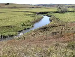 Yarrowitch River near the Oxley Highway | |
| Location | |
| Country | Australia |
| State | New South Wales |
| Region | New England Tablelands (IBRA), Northern Tablelands |
| Local government area | Walcha |
| Physical characteristics | |
| Source | Great Dividing Range |
| • location | near Yarrowitch |
| • elevation | 1,100 m (3,600 ft) |
| Mouth | confluence with the Apsley River |
• location | near Tia |
• elevation | 283 m (928 ft) |
| Length | 62 km (39 mi) |
| Basin features | |
| River system | Macleay River catchment |
| Tributaries | |
| • right | Warnes River |
| National parks | Mummel Gulf NP, Oxley Wild Rivers NP |
| [1] | |
Course and features
Yarrowitch River rises within Mummel Gulf National Park on the northern slopes of the Great Dividing Range southwest of Yarrowitch, and flows generally north northeast, joined by the Warnes River before reaching its confluence with the Apsley River, southwest of Tia. The river descends 822 metres (2,697 ft) over its 62 kilometres (39 mi) course;[1] spilling over the Yarrowitch Falls in the Oxley Wild Rivers National Park.
In its middle reaches, the Yarrowitch River passes through rich grazing country used for rearing livestock, principally beef cattle.
References
- "Map of Yarrowitch River, NSW". Bonzle Digital Atlas of Australia. Retrieved 5 March 2013.
External links
- "Macleay River catchment" (map). Office of Environment and Heritage. Government of New South Wales.
River systems and rivers of the Northern Rivers catchments, New South Wales, Australia | |
|---|---|
| Tweed Shire and Tweed River | |
| Byron Shire and Brunswick River | |
| Richmond Valley and Richmond River | |
| Clarence Valley and Clarence River |
|
| Coffs Harbour, Bellingen Shire, and Bellinger River | |
| Nambucca Shire, Kempsey Shire, and Nambucca-Macleay rivers | |
| Port Macquarie-Hastings and Hastings River | |
| |
This article is issued from Wikipedia. The text is licensed under Creative Commons - Attribution - Sharealike. Additional terms may apply for the media files.