Gara River (Australia)
Gara River, a perennial river[1] that is a tributary of the Macleay River, is located in the Northern Tablelands region of New South Wales, Australia.
| Gara River Gyra River, Ryanda Creek, Falconer Creek, Malpas Creek[1] | |
|---|---|
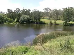 Blue Hole in the Gara River, near Armidale | |
| Location | |
| Country | Australia |
| State | New South Wales |
| Region | New England Tablelands (IBRA), Northern Tablelands |
| Local government areas | Guyra, Armidale Dumaresq |
| Physical characteristics | |
| Source | Ben Lomond Range, Great Dividing Range |
| • location | near Llangothlin |
| • elevation | 1,280 m (4,200 ft) |
| Mouth | confluence with the Macleay River |
• location | Salisbury Waters within Oxley Wild Rivers National Park, near Armidale |
• elevation | 388 m (1,273 ft) |
| Length | 91 km (57 mi) |
| Basin features | |
| River system | Macleay River |
| Tributaries | |
| • left | Cooney Creek |
| • right | Ryanda Creek, Commissioners Waters, Powers Creek |
| National park | Oxley Wild Rivers NP |
| [2] | |
Course and features
The river rises at the junction of the southern slopes of the Great Dividing Range and the Ben Lomond Range, near Llangothlin, and flows generally south and southeast, joined by four minor tributaries, until the river reaches a junction with Salisbury Waters within Oxley Wild Rivers National Park and descends to its confluence with the Macleay River, below Blue Nobby Mountain, south east of Armidale. The river descends 892 metres (2,927 ft) over its 91 kilometres (57 mi) course and is impounded by Guyra Dam and Malpas Reservoir.[2]
In its lower reaches, the Gara River is transversed by the Waterfall Way.[2]
See also
References
- "Gara River". Geographical Names Register (GNR) of NSW. Geographical Names Board of New South Wales. Retrieved 24 January 2013.

- "Map of Gara River". Bonzle.com. Retrieved 6 February 2013.
External links
- "Macleay River catchment" (map). Office of Environment and Heritage. Government of New South Wales.
- Northern Rivers Geology Blog - Macleay River
River systems and rivers of the Northern Rivers catchments, New South Wales, Australia | |
|---|---|
| Tweed Shire and Tweed River | |
| Byron Shire and Brunswick River | |
| Richmond Valley and Richmond River | |
| Clarence Valley and Clarence River |
|
| Coffs Harbour, Bellingen Shire, and Bellinger River | |
| Nambucca Shire, Kempsey Shire, and Nambucca-Macleay rivers | |
| Port Macquarie-Hastings and Hastings River | |
| |