National Register of Historic Places listings in Johnson County, Kansas
This is a list of the National Register of Historic Places listings in Johnson County, Kansas.
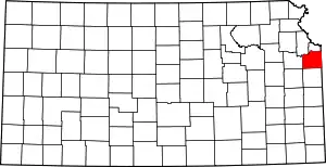
Location of Johnson County in Kansas
This is intended to be a complete list of the properties and districts on the National Register of Historic Places in Johnson County, Kansas, United States. The locations of National Register properties and districts for which the latitude and longitude coordinates are included below, may be seen in a map.[1]
There are 27 properties and districts listed on the National Register in the county, including one National Historic Landmark.
- This National Park Service list is complete through NPS recent listings posted February 5, 2021.[2]
Current listings
| [3] | Name on the Register[4] | Image | Date listed[5] | Location | City or town | Description |
|---|---|---|---|---|---|---|
| 1 | Blackfeather Farm | August 22, 1996 (#96000918) |
8140 W. 183rd St. 38°47′54″N 94°40′53″W |
Stilwell | ||
| 2 | Broadmoor Ranch House Historic District | February 7, 2011 (#10001208) |
6900-7017 W. 68th St., 6900-7001 W. 69th St., 6900-7019 W. 69th Terr. 39°00′15″N 94°39′59″W |
Overland Park | ||
| 3 | Ensor Farm | 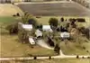 Ensor Farm |
February 27, 2004 (#04000079) |
18995 W. 183rd St. 38°47′51″N 94°48′36″W |
Olathe | |
| 4 | Herman B. Foster House | 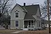 Herman B. Foster House |
November 28, 2007 (#07001226) |
204 W. Main St. 38°48′48″N 94°55′51″W |
Gardner | |
| 5 | Harmon Park Swale | September 21, 2018 (#13000880) |
7700 Mission Rd. 38°59′20″N 94°37′52″W |
Prairie Village | ||
| 6 | R.W. Hocker Subdivision, Lot K Spec House | 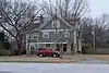 R.W. Hocker Subdivision, Lot K Spec House |
March 27, 2017 (#100000799) |
5532 Knox Ave. 39°01′42″N 94°41′54″W |
Merriam | |
| 7 | Horn-Vincent-Russell Estate | 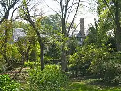 Horn-Vincent-Russell Estate |
July 25, 1997 (#97000819) |
6624 Wenonga Rd. 39°00′36″N 94°37′40″W |
Mission Hills | |
| 8 | Lanesfield School | 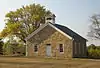 Lanesfield School |
October 13, 1988 (#88001902) |
18745 S. Dillie Rd. 38°47′22″N 94°59′33″W |
Edgerton | |
| 9 | Franklin R. Lanter House | 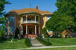 Franklin R. Lanter House |
October 10, 2007 (#07001066) |
562 W. Park St. 38°52′56″N 94°49′38″W |
Olathe | |
| 10 | Lone Elm Campground Swale |  Lone Elm Campground Swale |
April 6, 2014 (#14000121) |
21151 W. 167th St. 38°49′23″N 94°49′55″W |
Olathe | Part of the Santa Fe Trail MPS |
| 11 | Loomis Historic District |  Loomis Historic District |
May 17, 2006 (#06000390) |
8325 Johnson Dr., 5900 Hadley, 5923 Hadley 39°01′25″N 94°40′53″W |
Merriam | |
| 12 | J. B. Mahaffie House | 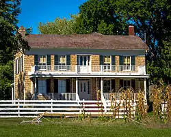 J. B. Mahaffie House |
August 29, 1977 (#77000583) |
1100 Kansas City Rd. 38°53′31″N 94°48′04″W |
Olathe | |
| 13 | John McCarthy House | 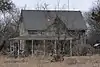 John McCarthy House |
July 10, 2000 (#00000758) |
19700 Sunflower Rd. 38°46′14″N 95°00′07″W |
Edgerton | |
| 14 | Olathe Cemetery |  Olathe Cemetery |
January 11, 2017 (#100000514) |
738 Chestnut St. 38°53′43″N 94°49′04″W |
Olathe | |
| 15 | Albert Ott House |  Albert Ott House |
April 1, 1998 (#98000267) |
401 S. Harrison St. 38°52′41″N 94°48′56″W |
Olathe | |
| 16 | Overland Theater | 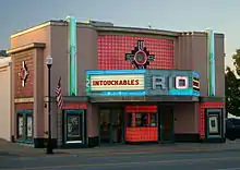 Overland Theater |
February 9, 2005 (#05000009) |
7204 W. 80th St. 38°59′10″N 94°40′09″W |
Overland Park | |
| 17 | Martin Van Buren Parker House | 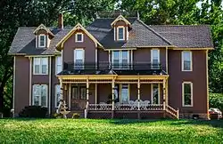 Martin Van Buren Parker House |
December 20, 1988 (#88002829) |
631 W. Park St. 38°52′58″N 94°49′48″W |
Olathe | |
| 18 | I. O. Pickering House | 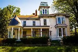 I. O. Pickering House |
December 1, 1980 (#80001468) |
507 W. Park St. 38°53′01″N 94°49′28″W |
Olathe | |
| 19 | Redel Historic District | August 16, 1996 (#96000897) |
16310 Mission Rd., 3950, 3970, 3990, and 4010 W. 163rd St. 38°49′57″N 94°37′51″W |
Stilwell | ||
| 20 | Shawnee Methodist Mission | 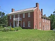 Shawnee Methodist Mission |
October 15, 1966 (#66000345) |
53rd St. at Mission Rd. 39°02′00″N 94°37′29″W |
Fairway | |
| 21 | Sunflower Village Historic District | November 18, 2014 (#14000929) |
36000 103rd St. 38°56′43″N 95°00′11″W |
DeSoto | ||
| 22 | William Thomas Turner Barn | 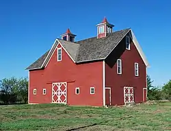 William Thomas Turner Barn |
April 1, 1999 (#99000420) |
19805 S. Moonlight Rd. 38°46′11″N 94°54′28″W |
Gardner | |
| 23 | Virginia School District No. 33 | 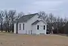 Virginia School District No. 33 |
May 19, 2004 (#04000454) |
7301 Mize Road 38°59′46″N 94°52′52″W |
Shawnee | Relocated in 2007 |
| 24 | Herman J. and Ella B. Voigts House | 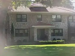 Herman J. and Ella B. Voigts House |
May 18, 1995 (#95000603) |
2405 W. 103rd St. 38°56′31″N 94°37′09″W |
Leawood | |
| 25 | Westwood Hills Historic District | December 4, 2013 (#13000816) |
Bounded by State Line Rd., W. 50th St. Terr., Rainbow Blvd., N. side of W. 48th St. Terr. 39°02′21″N 94°36′35″W |
Westwood Hills | ||
| 26 | Wolcott House | 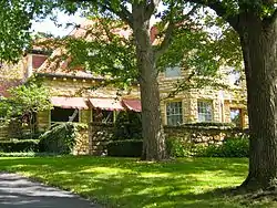 Wolcott House |
May 2, 2001 (#01000448) |
5701 Oakwood Rd. 39°01′30″N 94°36′43″W |
Mission Hills | |
| 27 | WPA Beach House at Gardner Lake | 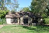 WPA Beach House at Gardner Lake |
June 25, 1992 (#92000826) |
Western shore of Gardner Lake, north of Gardner 38°50′55″N 94°55′43″W |
Gardner |
See also
| Wikimedia Commons has media related to National Register of Historic Places in Johnson County, Kansas. |
References
- The latitude and longitude information provided in this table was derived originally from the National Register Information System, which has been found to be fairly accurate for about 99% of listings. Some locations in this table may have been corrected to current GPS standards.
- "National Register of Historic Places: Weekly List Actions". National Park Service, United States Department of the Interior. Retrieved on February 5, 2021.
- Numbers represent an alphabetical ordering by significant words. Various colorings, defined here, differentiate National Historic Landmarks and historic districts from other NRHP buildings, structures, sites or objects.
- "National Register Information System". National Register of Historic Places. National Park Service. March 13, 2009.
- The eight-digit number below each date is the number assigned to each location in the National Register Information System database, which can be viewed by clicking the number.

Municipalities and communities of Johnson County, Kansas, United States | ||
|---|---|---|
| Cities | Map of Kansas highlighting Johnson County | |
| Unincorporated communities | ||
| Townships | ||
| Footnotes | ‡This populated place also has portions in an adjacent county or counties | |
| ||
This article is issued from Wikipedia. The text is licensed under Creative Commons - Attribution - Sharealike. Additional terms may apply for the media files.
