Landos
Landos is a commune in the Haute-Loire department in south-central France.
Landos | |
|---|---|
Commune | |
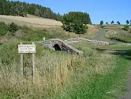 Castier Bridge | |
Location of Landos 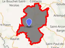
| |
 Landos  Landos | |
| Coordinates: 44°50′37″N 3°49′57″E | |
| Country | France |
| Region | Auvergne-Rhône-Alpes |
| Department | Haute-Loire |
| Arrondissement | Le Puy-en-Velay |
| Canton | Velay volcanique |
| Government | |
| • Mayor (2014–2020) | Jean-Louis Reynaud |
| Area 1 | 36.51 km2 (14.10 sq mi) |
| Population (2017-01-01)[1] | 891 |
| • Density | 24/km2 (63/sq mi) |
| Time zone | UTC+01:00 (CET) |
| • Summer (DST) | UTC+02:00 (CEST) |
| INSEE/Postal code | 43111 /43340 |
| Elevation | 978–1,237 m (3,209–4,058 ft) (avg. 1,120 m or 3,670 ft) |
| 1 French Land Register data, which excludes lakes, ponds, glaciers > 1 km2 (0.386 sq mi or 247 acres) and river estuaries. | |
The Robert Louis Stevenson Trail (GR 70), a popular long-distance path, runs through the town, which is also on a disused railway from Le Puy-en-Velay to Langogne.[2]
Population
| Year | Pop. | ±% |
|---|---|---|
| 1793 | 809 | — |
| 1806 | 917 | +13.3% |
| 1821 | 874 | −4.7% |
| 1831 | 896 | +2.5% |
| 1841 | 960 | +7.1% |
| 1851 | 998 | +4.0% |
| 1861 | 1,042 | +4.4% |
| 1872 | 1,067 | +2.4% |
| 1881 | 1,130 | +5.9% |
| 1891 | 1,274 | +12.7% |
| 1901 | 1,339 | +5.1% |
| 1911 | 1,618 | +20.8% |
| 1921 | 1,426 | −11.9% |
| 1931 | 1,366 | −4.2% |
| 1946 | 1,126 | −17.6% |
| 1954 | 1,126 | +0.0% |
| 1962 | 1,098 | −2.5% |
| 1968 | 1,205 | +9.7% |
| 1975 | 1,147 | −4.8% |
| 1982 | 1,064 | −7.2% |
| 1990 | 1,006 | −5.5% |
| 1999 | 901 | −10.4% |
| 2010 | 932 | +3.4% |
| 2017 | 891 | −4.4% |
References
- "Populations légales 2017". INSEE. Retrieved 6 January 2020.
- Castle, Alan (2007). The Robert Louis Stevenson Trail (2nd ed.). Cicerone. p. 82. ISBN 978-1-85284-511-7.
| Wikimedia Commons has media related to Landos. |
| Authority control |
|
|---|
This article is issued from Wikipedia. The text is licensed under Creative Commons - Attribution - Sharealike. Additional terms may apply for the media files.