Lapte
Lapte is a commune in the Haute-Loire department in south-central France, located 23 kilometres southwest of Firminy. Lapte is surrounded by the communes Grézac, Chenereilles and Raucoules.
Lapte | |
|---|---|
Commune | |
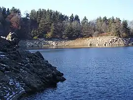 Lac de Lavalette | |
Location of Lapte 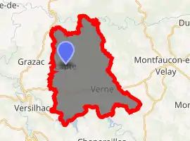
| |
 Lapte  Lapte | |
| Coordinates: 45°11′11″N 4°13′04″E | |
| Country | France |
| Region | Auvergne-Rhône-Alpes |
| Department | Haute-Loire |
| Arrondissement | Yssingeaux |
| Canton | Yssingeaux |
| Government | |
| • Mayor (2014–2020) | André Defour |
| Area 1 | 30.75 km2 (11.87 sq mi) |
| Population (2017-01-01)[1] | 1,715 |
| • Density | 56/km2 (140/sq mi) |
| Time zone | UTC+01:00 (CET) |
| • Summer (DST) | UTC+02:00 (CEST) |
| INSEE/Postal code | 43114 /43200 |
| Elevation | 600–914 m (1,969–2,999 ft) (avg. 843 m or 2,766 ft) |
| 1 French Land Register data, which excludes lakes, ponds, glaciers > 1 km2 (0.386 sq mi or 247 acres) and river estuaries. | |
Geography
The municipality of Lapte covers 30.8 square kilometres. It is located at 860 metres above the Lignon du Velay river, where it converges with the Denieres. The river Lignon du Velay also flows through the commune.
Population
|
|
References
- "Populations légales 2017". INSEE. Retrieved 6 January 2020.
| Wikimedia Commons has media related to Lapte. |
| Authority control |
|---|
This article is issued from Wikipedia. The text is licensed under Creative Commons - Attribution - Sharealike. Additional terms may apply for the media files.