Roche-en-Régnier
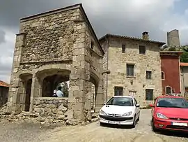
Roche-en-Régnier is a commune in the Haute-Loire department in south-central France. It is best known for a medieval castle and "Table d'orientation" which points out the other visible towns and hills of the Loire Valley.
Roche-en-Régnier | |
|---|---|
Commune | |
 | |
 Coat of arms | |
Location of Roche-en-Régnier 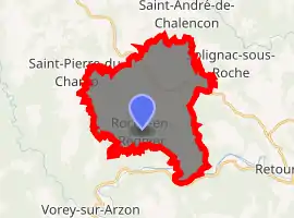
| |
 Roche-en-Régnier  Roche-en-Régnier | |
| Coordinates: 45°13′20″N 3°56′32″E | |
| Country | France |
| Region | Auvergne-Rhône-Alpes |
| Department | Haute-Loire |
| Arrondissement | Le Puy-en-Velay |
| Canton | Plateau du Haut-Velay granitique |
| Government | |
| • Mayor (2014–2020) | Eric Dunis |
| Area 1 | 26.92 km2 (10.39 sq mi) |
| Population (2017-01-01)[1] | 500 |
| • Density | 19/km2 (48/sq mi) |
| Time zone | UTC+01:00 (CET) |
| • Summer (DST) | UTC+02:00 (CEST) |
| INSEE/Postal code | 43164 /43810 |
| Elevation | 504–1,076 m (1,654–3,530 ft) (avg. 860 m or 2,820 ft) |
| 1 French Land Register data, which excludes lakes, ponds, glaciers > 1 km2 (0.386 sq mi or 247 acres) and river estuaries. | |
Population
| Year | Pop. | ±% |
|---|---|---|
| 1793 | 1,430 | — |
| 1806 | 1,302 | −9.0% |
| 1821 | 1,558 | +19.7% |
| 1831 | 1,685 | +8.2% |
| 1841 | 1,657 | −1.7% |
| 1851 | 1,687 | +1.8% |
| 1861 | 1,657 | −1.8% |
| 1872 | 1,709 | +3.1% |
| 1881 | 1,784 | +4.4% |
| 1891 | 1,810 | +1.5% |
| 1911 | 1,608 | −11.2% |
| 1921 | 1,300 | −19.2% |
| 1931 | 1,045 | −19.6% |
| 1946 | 860 | −17.7% |
| 1954 | 794 | −7.7% |
| 1962 | 670 | −15.6% |
| 1968 | 542 | −19.1% |
| 1975 | 447 | −17.5% |
| 1982 | 409 | −8.5% |
| 1990 | 409 | +0.0% |
| 1999 | 387 | −5.4% |
| 2010 | 491 | +26.9% |
| 2017 | 500 | +1.8% |
References
- "Populations légales 2017". INSEE. Retrieved 6 January 2020.
| Wikimedia Commons has media related to Roche-en-Régnier. |
| Authority control |
|
|---|
This article is issued from Wikipedia. The text is licensed under Creative Commons - Attribution - Sharealike. Additional terms may apply for the media files.