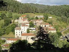
Saint-Pal-de-Senouire
Saint-Pal-de-Senouire is a commune in the Haute-Loire department in south-central France.
Saint-Pal-de-Senouire | |
|---|---|
Commune | |
 | |
 Coat of arms | |
Location of Saint-Pal-de-Senouire 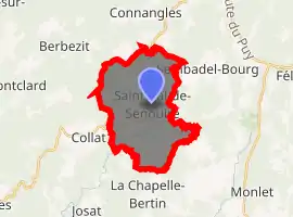
| |
 Saint-Pal-de-Senouire  Saint-Pal-de-Senouire | |
| Coordinates: 45°15′36″N 3°39′05″E | |
| Country | France |
| Region | Auvergne-Rhône-Alpes |
| Department | Haute-Loire |
| Arrondissement | Brioude |
| Canton | Plateau du Haut-Velay granitique |
| Government | |
| • Mayor (2014–2020) | Alain Fouillit |
| Area 1 | 18.35 km2 (7.08 sq mi) |
| Population (2017-01-01)[1] | 109 |
| • Density | 5.9/km2 (15/sq mi) |
| Time zone | UTC+01:00 (CET) |
| • Summer (DST) | UTC+02:00 (CEST) |
| INSEE/Postal code | 43214 /43160 |
| Elevation | 789–1,204 m (2,589–3,950 ft) (avg. 840 m or 2,760 ft) |
| 1 French Land Register data, which excludes lakes, ponds, glaciers > 1 km2 (0.386 sq mi or 247 acres) and river estuaries. | |
Geography
The Senouire flows south through the middle of the commune.
Population
| Year | Pop. | ±% |
|---|---|---|
| 1793 | 699 | — |
| 1806 | 742 | +6.2% |
| 1821 | 673 | −9.3% |
| 1831 | 716 | +6.4% |
| 1841 | 737 | +2.9% |
| 1851 | 663 | −10.0% |
| 1861 | 674 | +1.7% |
| 1872 | 695 | +3.1% |
| 1881 | 692 | −0.4% |
| 1891 | 669 | −3.3% |
| 1901 | 618 | −7.6% |
| 1911 | 542 | −12.3% |
| 1921 | 509 | −6.1% |
| 1931 | 415 | −18.5% |
| 1946 | 336 | −19.0% |
| 1954 | 294 | −12.5% |
| 1962 | 300 | +2.0% |
| 1968 | 268 | −10.7% |
| 1975 | 217 | −19.0% |
| 1982 | 174 | −19.8% |
| 1990 | 143 | −17.8% |
| 1999 | 118 | −17.5% |
| 2011 | 105 | −11.0% |
| 2017 | 109 | +3.8% |
External links
| Wikimedia Commons has media related to Saint-Pal-de-Senouire. |
| Authority control |
|---|
This article is issued from Wikipedia. The text is licensed under Creative Commons - Attribution - Sharealike. Additional terms may apply for the media files.