Saint-Martin-de-Fugères
Saint-Martin-de-Fugères is a commune in the Haute-Loire department in south-central France.
Saint-Martin-de-Fugères | |
|---|---|
Commune | |
 | |
Location of Saint-Martin-de-Fugères 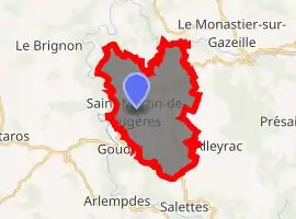
| |
 Saint-Martin-de-Fugères  Saint-Martin-de-Fugères | |
| Coordinates: 44°54′24″N 3°56′07″E | |
| Country | France |
| Region | Auvergne-Rhône-Alpes |
| Department | Haute-Loire |
| Arrondissement | Le Puy-en-Velay |
| Canton | Mézenc |
| Government | |
| • Mayor (2014–2020) | Jean-Pierre Pons |
| Area 1 | 20.87 km2 (8.06 sq mi) |
| Population (2017-01-01)[1] | 219 |
| • Density | 10/km2 (27/sq mi) |
| Time zone | UTC+01:00 (CET) |
| • Summer (DST) | UTC+02:00 (CEST) |
| INSEE/Postal code | |
| Elevation | 725–1,185 m (2,379–3,888 ft) (avg. 1,003 m or 3,291 ft) |
| 1 French Land Register data, which excludes lakes, ponds, glaciers > 1 km2 (0.386 sq mi or 247 acres) and river estuaries. | |
Population
| Year | Pop. | ±% |
|---|---|---|
| 1793 | 1,216 | — |
| 1806 | 1,234 | +1.5% |
| 1821 | 1,218 | −1.3% |
| 1831 | 1,277 | +4.8% |
| 1841 | 1,311 | +2.7% |
| 1851 | 1,260 | −3.9% |
| 1861 | 1,254 | −0.5% |
| 1872 | 1,112 | −11.3% |
| 1881 | 1,057 | −4.9% |
| 1891 | 1,156 | +9.4% |
| 1901 | 1,188 | +2.8% |
| 1911 | 1,080 | −9.1% |
| 1921 | 973 | −9.9% |
| 1931 | 849 | −12.7% |
| 1946 | 761 | −10.4% |
| 1954 | 583 | −23.4% |
| 1962 | 526 | −9.8% |
| 1968 | 512 | −2.7% |
| 1975 | 422 | −17.6% |
| 1982 | 363 | −14.0% |
| 1990 | 266 | −26.7% |
| 1999 | 245 | −7.9% |
| 2010 | 204 | −16.7% |
| 2017 | 219 | +7.4% |
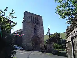
Sights
The Robert Louis Stevenson Trail (GR 70), a popular long-distance path, runs through the village.[4]
References
- "Populations légales 2017". INSEE. Retrieved 6 January 2020.
- "INSEE commune file".
- "INSEE commune file".
- Castle, Alan (2007). The Robert Louis Stevenson Trail (2nd ed.). Cicerone. pp. 63–64. ISBN 978-1-85284-511-7.
| Wikimedia Commons has media related to Saint-Martin-de-Fugères. |
| Authority control |
|---|
This article is issued from Wikipedia. The text is licensed under Creative Commons - Attribution - Sharealike. Additional terms may apply for the media files.