Goudet
Goudet is a commune in the Haute-Loire department in south-central France. The village stands on the upper reaches of the River Loire and is overlooked by the Château de Beaufort, built in the 13th century, of importance during the Hundred Years War and the French Wars of Religion but abandoned after the Revolution of 1789.[2]
Goudet | |
|---|---|
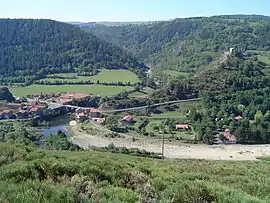 The Loire and the Château de Beaufort | |
Location of Goudet 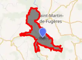
| |
 Goudet  Goudet | |
| Coordinates: 44°53′24″N 3°55′35″E | |
| Country | France |
| Region | Auvergne-Rhône-Alpes |
| Department | Haute-Loire |
| Arrondissement | Le Puy-en-Velay |
| Canton | Mézenc |
| Government | |
| • Mayor (2014–2020) | Joël Lacour |
| Area 1 | 4.5 km2 (1.7 sq mi) |
| Population (2017-01-01)[1] | 60 |
| • Density | 13/km2 (35/sq mi) |
| Time zone | UTC+01:00 (CET) |
| • Summer (DST) | UTC+02:00 (CEST) |
| INSEE/Postal code | 43101 /43150 |
| Elevation | 733–1,018 m (2,405–3,340 ft) (avg. 770 m or 2,530 ft) |
| 1 French Land Register data, which excludes lakes, ponds, glaciers > 1 km2 (0.386 sq mi or 247 acres) and river estuaries. | |
The Robert Louis Stevenson Trail (GR 70), a popular long-distance path, runs through the village,[3] as do the GR3 and GR40.[4]
Population
|
|
References
- "Populations légales 2017". INSEE. Retrieved 6 January 2020.
- Base Mérimée: Château de Beaufort, Ministère français de la Culture. (in French)
- Castle, Alan (2007). The Robert Louis Stevenson Trail (2nd ed.). Cicerone. pp. 65–67. ISBN 978-1-85284-511-7.
- "Géoportail". IGN. Retrieved 27 June 2017.
| Wikimedia Commons has media related to Goudet. |
| Authority control |
|
|---|
This article is issued from Wikipedia. The text is licensed under Creative Commons - Attribution - Sharealike. Additional terms may apply for the media files.