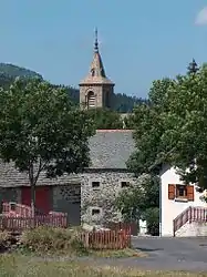
Les Estables
Les Estables is a commune in the Haute-Loire department in south-central France.
Les Estables | |
|---|---|
Commune | |
 | |
Location of Les Estables 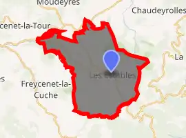
| |
 Les Estables  Les Estables | |
| Coordinates: 44°54′19″N 4°09′18″E | |
| Country | France |
| Region | Auvergne-Rhône-Alpes |
| Department | Haute-Loire |
| Arrondissement | Le Puy-en-Velay |
| Canton | Mézenc |
| Government | |
| • Mayor (2014–2020) | Philippe Brun |
| Area 1 | 33.94 km2 (13.10 sq mi) |
| Population (2017-01-01)[1] | 333 |
| • Density | 9.8/km2 (25/sq mi) |
| Time zone | UTC+01:00 (CET) |
| • Summer (DST) | UTC+02:00 (CEST) |
| INSEE/Postal code | 43091 /43150 |
| Elevation | 1,033–1,725 m (3,389–5,659 ft) (avg. 1,346 m or 4,416 ft) |
| 1 French Land Register data, which excludes lakes, ponds, glaciers > 1 km2 (0.386 sq mi or 247 acres) and river estuaries. | |
History
A young geometer, who was doing survey work in the area for the Cassini maps, the first modern maps of France, was hacked to death by suspicious villagers in the 1740s.[2]
Population
|
|
References
- "Populations légales 2017". INSEE. Retrieved 6 January 2020.
- Robb, Graham (2007). The Discovery of France. p. 5. ISBN 978-0-393-05973-1.
| Wikimedia Commons has media related to Les Estables. |
| Authority control |
|
|---|
This article is issued from Wikipedia. The text is licensed under Creative Commons - Attribution - Sharealike. Additional terms may apply for the media files.