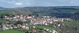
Le Monastier-sur-Gazeille
Le Monastier-sur-Gazeille is a commune in the Haute-Loire department in south-central France.
Le Monastier-sur-Gazeille | |
|---|---|
Commune | |
 | |
 Coat of arms | |
Location of Le Monastier-sur-Gazeille 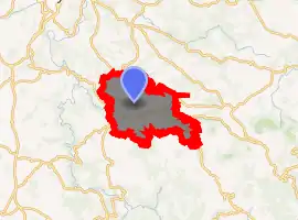
| |
 Le Monastier-sur-Gazeille  Le Monastier-sur-Gazeille | |
| Coordinates: 44°56′23″N 3°59′46″E | |
| Country | France |
| Region | Auvergne-Rhône-Alpes |
| Department | Haute-Loire |
| Arrondissement | Le Puy-en-Velay |
| Canton | Mézenc |
| Government | |
| • Mayor (2014–2020) | Michel Arcis |
| Area 1 | 39.39 km2 (15.21 sq mi) |
| Population (2017-01-01)[1] | 1,789 |
| • Density | 45/km2 (120/sq mi) |
| Time zone | UTC+01:00 (CET) |
| • Summer (DST) | UTC+02:00 (CEST) |
| INSEE/Postal code | 43135 /43150 |
| Elevation | 752–1,283 m (2,467–4,209 ft) (avg. 950 m or 3,120 ft) |
| 1 French Land Register data, which excludes lakes, ponds, glaciers > 1 km2 (0.386 sq mi or 247 acres) and river estuaries. | |
Population
| Year | Pop. | ±% |
|---|---|---|
| 1793 | 3,515 | — |
| 1806 | 4,355 | +23.9% |
| 1821 | 3,105 | −28.7% |
| 1831 | 3,420 | +10.1% |
| 1841 | 3,461 | +1.2% |
| 1851 | 3,464 | +0.1% |
| 1861 | 3,589 | +3.6% |
| 1872 | 3,831 | +6.7% |
| 1881 | 3,749 | −2.1% |
| 1891 | 3,759 | +0.3% |
| 1901 | 3,743 | −0.4% |
| 1911 | 3,650 | −2.5% |
| 1921 | 3,554 | −2.6% |
| 1931 | 3,104 | −12.7% |
| 1946 | 2,255 | −27.4% |
| 1954 | 2,065 | −8.4% |
| 1962 | 2,085 | +1.0% |
| 1968 | 2,085 | +0.0% |
| 1975 | 1,966 | −5.7% |
| 1982 | 1,911 | −2.8% |
| 1990 | 1,828 | −4.3% |
| 1999 | 1,734 | −5.1% |
| 2007 | 1,738 | +0.2% |
| 2017 | 1,789 | +2.9% |
Sights
The official start of the Robert Louis Stevenson Trail (GR 70), a popular long-distance path, is at Place de la Poste in the centre of the village, marked by a plaque. Stevenson spent about a month in Le Monastier before setting off on his travels, as recounted in Travels with a Donkey in the Cévennes.[2]
References
- "Populations légales 2017". INSEE. Retrieved 6 January 2020.
- Castle, Alan (2007). The Robert Louis Stevenson Trail (2nd ed.). Cicerone. pp. 61–62. ISBN 978-1-85284-511-7.
External links
| Wikimedia Commons has media related to Le Monastier-sur-Gazeille. |
| Authority control |
|---|
This article is issued from Wikipedia. The text is licensed under Creative Commons - Attribution - Sharealike. Additional terms may apply for the media files.