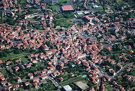
Sainte-Florine
Sainte-Florine is a commune in the Haute-Loire department in south-central France.
Sainte-Florine | |
|---|---|
Commune | |
 | |
Location of Sainte-Florine 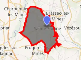
| |
 Sainte-Florine  Sainte-Florine | |
| Coordinates: 45°24′21″N 3°19′05″E | |
| Country | France |
| Region | Auvergne-Rhône-Alpes |
| Department | Haute-Loire |
| Arrondissement | Brioude |
| Canton | Sainte-Florine |
| Government | |
| • Mayor (2014–2020) | Nicole Chassin |
| Area 1 | 7.67 km2 (2.96 sq mi) |
| Population (2017-01-01)[1] | 3,154 |
| • Density | 410/km2 (1,100/sq mi) |
| Time zone | UTC+01:00 (CET) |
| • Summer (DST) | UTC+02:00 (CEST) |
| INSEE/Postal code | 43185 /43250 |
| Elevation | 400–511 m (1,312–1,677 ft) (avg. 430 m or 1,410 ft) |
| 1 French Land Register data, which excludes lakes, ponds, glaciers > 1 km2 (0.386 sq mi or 247 acres) and river estuaries. | |
Population
| Year | Pop. | ±% |
|---|---|---|
| 1793 | 942 | — |
| 1800 | 1,104 | +17.2% |
| 1806 | 1,054 | −4.5% |
| 1821 | 1,274 | +20.9% |
| 1831 | 1,266 | −0.6% |
| 1836 | 1,369 | +8.1% |
| 1841 | 1,573 | +14.9% |
| 1846 | 1,608 | +2.2% |
| 1851 | 1,676 | +4.2% |
| 1856 | 1,733 | +3.4% |
| 1861 | 1,918 | +10.7% |
| 1866 | 2,080 | +8.4% |
| 1872 | 2,181 | +4.9% |
| 1876 | 2,504 | +14.8% |
| 1881 | 2,558 | +2.2% |
| 1886 | 2,930 | +14.5% |
| 1891 | 2,930 | +0.0% |
| 1896 | 3,079 | +5.1% |
| 1901 | 3,243 | +5.3% |
| 1906 | 3,027 | −6.7% |
| 1911 | 2,896 | −4.3% |
| 1921 | 2,696 | −6.9% |
| 1926 | 2,847 | +5.6% |
| 1931 | 2,845 | −0.1% |
| 1936 | 2,810 | −1.2% |
| 1946 | 2,755 | −2.0% |
| 1954 | 2,864 | +4.0% |
| 1962 | 3,291 | +14.9% |
| 1968 | 3,625 | +10.1% |
| 1975 | 3,673 | +1.3% |
| 1982 | 3,335 | −9.2% |
| 1990 | 3,021 | −9.4% |
| 1999 | 3,002 | −0.6% |
| 2006 | 3,105 | +3.4% |
| 2007 | 3,113 | +0.3% |
| 2008 | 3,121 | +0.3% |
| 2009 | 3,134 | +0.4% |
| 2010 | 3,145 | +0.4% |
| 2011 | 3,096 | −1.6% |
| 2012 | 3,072 | −0.8% |
| 2013 | 3,047 | −0.8% |
| 2014 | 3,079 | +1.1% |
References
- "Populations légales 2017". INSEE. Retrieved 6 January 2020.
| Wikimedia Commons has media related to Sainte-Florine. |
| Authority control |
|---|
This article is issued from Wikipedia. The text is licensed under Creative Commons - Attribution - Sharealike. Additional terms may apply for the media files.