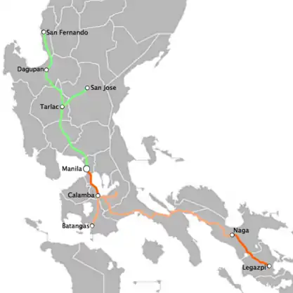
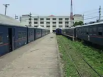
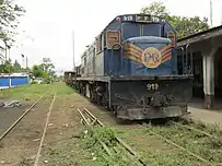
List of Philippine National Railways stations
Philippine National Railways used to provide passenger services in two directions from the capital, thus serving various towns and cities north and south of Manila. This list contains stations of both Northrail and Southrail, and the various spur lines from both Northrail and Southrail, as well as stations within Metro Manila. The Northrail is also known as the Green Line, while the Southrail is also known as the Orange Line. Former termini or terminal stations are in bold and former or defunct stations are in italic.
North Main Line (Northrail)
Stations along the Manila-San Fernando Line were abandoned and closed. San Fernando-Dagupan closed in 1983, Dagupan-Tarlac in 1988 and Tarlac-Malolos in 1989. The eruption of Mount Pinatubo further shortened services up to Meycauayan in 1991 until it was closed in 1997.
| Section | Year Opened | Length | Distance from Manila |
|---|---|---|---|
| Manila-Bagbag | March 24, 1891 | 44 km | 44 km |
| Bagbag-Mabalacat | February 2, 1892 | 43 | 87 |
| Mabalacat-Tarlac | June 1, 1892 | 32 | 119 |
| Tarlac-Dagupan | November 24, 1892 | 76 | 195 |
| Dagupan-San Fabian | January 11, 1908 | 12 | 207 |
| San Fabian-Rabon | July 5, 1908 | ||
| Rabon-Santo Tomas | November 14, 1908 | ||
| Santo Tomas-Agoo | December 4, 1908 | ||
| Agoo-South Aringay | July 26, 1909 | ||
| South Aringay-Aringay | 1910 | ||
| Aringay-Bauang Sur | October 14, 1912 | 13 | 253 |
| Bauang Sur-Bauang | January 16, 1929 | 2 | 255 |
| Bauang-San Fernando U | May 16, 1929 | 12 | 265 |
| San Fernando U-Sudipen | 1943 | 25 | 290 |
| San Fernando U-Bacnotan | January 25, 1955 | 18 | 283 |
La Union
- Sudipen – Sudipen (The line was extended here during the Japanese Occupation)
- Quirino – Brgy. Quirino, Bacnotan
- Maragayap – Brgy. Maragayap, Bacnotan
- Santa Cruz – Brgy. Santa Cruz, Bacnotan
- Bulala – Brgy. Bulala, Bacnotan
- Bacnotan – Bacnotan (Terminus since 1955)
- Baroro – Brgy. Baroro, Bacnotan
- Taboc – Brgy., San Juan
- San Juan – San Juan, La Union
- Bato – Brgy. Bato, San Juan
- Mameltac – Brgy. Saoay, San Fernando
- Biday – Brgy. Biday, San Fernando
- San Fernando (San Fernando U) – San Fernando City
- Romas – Brgy. Paringao, Bauang (opened in 1931)
- Bauang – Bauang
- Calumbaya (Bauang Sur) – Brgy. Calumbaya, Bauang
- Santiago – Brgy. Santiago, Bauang
- Urayong – Brgy. Urayong, Bauang
- Caba (Cava) – Caba
- Aringay – Aringay [Terminus for the Aringay-Baguio Line]
- South Aringay – Aringay (Temporary station during the construction of the Aringay Bridge)
- Paraton – Brgy. San Eugenio, Aringay
- Agoo – Agoo
- Santo Tomas (Santo Tomas U) – Santo Tomas
- Cupang – Brgy. Cupang, Santo Tomas
- Old Damortis – Brgy. Damortis, Rosario (Original Damortis Sta.)
- Damortis – Brgy. Damortis, Rosario [terminus for car/bus shuttle service to Baguio via Kennon Road]
- Bani – Brgy. Bani, Rosario (opened in 1926)
- Rabon – Brgy. Rabon, Rosario
Pangasinan
- Alacan – Brgy. Alacan, San Fabian
- Sapdaan – Brgy. Sapdaan, San Fabian (Sapdaan)
- San Fabian – San Fabian (Terminus for the San Fabian-Camp One/San Fabian-Binday branch)
- Patalan – Brgy. Patalan, San Fabian
- Mangaldan – Mangaldan
- Maasin P. – Brgy. Maasin, Mangaldan
- Dagupan – Brgy. Mayombo, Dagupan City
- Calasiao – Calasiao (ruins)
- Buenlag – Brgy. Buenlag, Calasiao
- San Carlos – San Carlos City
- Malasiqui – Malasiqui
- Polong – Brgy. Polong, Malasiqui (flag stop, opened in 1939)
- Don Pedro – Brgy. Don Pedro, Malasiqui
- Quesada – Brgy. Nalsian Norte, Malasiqui (now a basketball court)
- Bayambang (Bayambang Pasajeros) – Bayambang
- Bautista (Bayambang Mercancias) – Bautista (Originally as Bayambang Freight between 1892 and 1900).
- Poponto – Brgy. Poponto, Bautista
Tarlac
- Moncada – Moncada (ruins)
- San Julian – Brgy. San Julian, Moncada (opened in 1926)
- Paniqui – Paniqui
- Gerona – Gerona (ruins)
- Parsolingan – Brgy. Parsolingan, Gerona (opened in 1929)
- Amacalan – Brgy. Amacalan, Gerona
- Dalayap – Brgy. Dalayap, Tarlac
- Tarlac City – Tarlac City Proper, Tarlac City
- San Miguel – Brgy San Miguel, Tarlac (opened in 1929)
- Murcia (San Agustin) – Concepcion, Tarlac
- New Clark City (proposed) – New Clark City, Capas, Tarlac [1]
- Capas – Capas, Tarlac (Museum for the Death March)
- Bamban (Bambang) – Bamban (ruins)
Pampanga
- Mabalacat – Mabalacat
- Dau – Brgy. Dau, Mabalacat
- Clark International Airport (proposed) – Clark International Airport, Clark Special Economic Zone, Angeles City[1]
- Clark (proposed) – Clark Special Economic Zone, Angeles City
- Balibago – Brgy. Balibago, Angeles City (Main gate – Clark Special Economic Zone)
- Angeles (Culiat) – Angeles City [1] (restored)
- Tablante – Brgy. Baliti, San Fernando (opened in 1924)
- Calulut – Brgy. Calulut, San Fernando City (flag stop)
- San Fernando – San Fernando, Pampanga[1][2] (restored)
- Santo Tomas – Santo Tomas, Pampanga (ruins)
- Macaluc – Brgy. Lourdes, Minalin (flag stop)
- Apalit – Apalit
- Sulipan – Brgy. Sulipan, Apalit
- Calumpit Norte – Brgy. Sulipan (temporary station during the construction of the Pampanga River Railroad Bridge, removed in 1894)
Bulacan
- Calumpit – Calumpit[3]
- Bagbag – Calumpit (opened as a temporary station in 1891)
- Malolos – near the Bulacan Provincial Capitol, Malolos City[1][3](PNR office)
- Dakila – Brgy. Dakila, Malolos
- Santa Isabel – Brgy. Santa Isabel, Malolos
- Tabang – Brgy, Tabang, Guiguinto
- Guiguinto – Guiguinto[3] (ruins)
- Balagtas (Bigaa) – Balagtas[3] (Terminus of the defunct Balagtas-Cabanatuan branch line)
- Bocaue (Bocaue) – Bocaue (ruins)
- Marilao – Marilao (demolished, soon to be under possible evaluation)
- ITM – Imperial Textile Mills, Marilao (soon to be under possible evaluation for reconstruction)
- Meycauayan – Meycauayan City[3](undergoing reconstruction)
Metro Manila
- Valenzuela (Polo) – near Gen. T. de Leon Street (C5), Barangay General T. de Leon, Valenzuela City (under possible evaluation)
- Governor Pascual (Acacia) – Brgy. Acacia, Malabon City
- Caloocan (2nd) – Samson Road, Caloocan, opened in the 1950s, also known as Caloocan Kadiwa station
- Caloocan (Kalookan) – Sangandaan, Caloocan City
- Asistio Avenue (10th Ave) – Grace Park, Caloocan City
- C-3 (5th Ave) – Grace Park, Caloocan City (flag stop)
- Solis – Tondo, Manila
- Tutuban – Tondo, Manila
East West Line (rapid transit)
The PNR East West line, or MRT Line 8, is a proposed rapid transit line in Metro Manila in the Philippines, generally running in an east–west direction along the Radial Road 7 and a portion of the Radial Road 8.
The line serves 11 stations on 9.4 kilometers (5.8 mi) of line. The rails are mostly elevated and erected either over or along the roads covered, with sections below ground. The western terminus of the line is the Quiapo station infont of Quiapo Church, while the eastern terminus of the line is the Diliman station along Commonwealth Avenue in Barangay Old Capitol Site, Quezon City.
Metro Manila
- Diliman – Quezon City
- EDSA – Quezon City
- Timog – Quezon City
- Roces – Quezon City
- Araneta – Quezon City
- Banaue – Quezon City
- Welcome – Quezon City
- Antipolo – Manila
- UST – Manila
- Lerma – Manila
- Quiapo – Manila
South Main Line (Southrail)
| Section | Date Opened | Distance | Distance from Manila |
|---|---|---|---|
| Santa Mesa-Paco | March 25, 1908 | 3 | 9 |
| Paco-Muntinlupa | June 21, 1908 | 22 | 32 |
| Muntinlupa-Calamba | January 24, 1909 | 24 | 56 |
| Calamba – Los Baños | August 15, 1910 | 8 | 64 |
| College- San Pablo | August 20, 1923 | 23 | 88 |
| Calamba-Malvar | January 4, 1910 | 19 | 75 |
| Malvar-San Pablo | July 3, 1911 | 19 | 94 |
| San Pablo-Tiaong | July 1912 | 9 | 98 |
| Tiaong-Lucena | February 10, 1913 | 34 | 133 |
| Lucena-Padre Burgos | 1914 | 32 | 165 |
| Padre Burgos – Hondagua – Calauag | May 10, 1916 | 77 | 243 |
| Calauag – Aloneros | August 16, 1921 | 12 | 255 |
| Aloneros – Manato | January 13, 1931 | 45 | 300 |
| Port Junction-Ragay-Lupi Viejo | August 28, 1933 | ||
| Lupi Viejo-Sipocot | September 13, 1931 | ||
| Sipocot-Libmanan | July 1930 | ||
| Libmanan-Pamplona | February 3, 1929 | ||
| Pamplona-Naga | October 18, 1921 | 12 | |
| Naga-Pili | April 1, 1920 | 28 | 405 |
| Baao-Iriga | August 1915 | ||
| Iriga Legazpi- Tabaco | November 1914 | 62 | 474 |
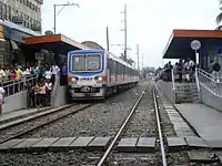
Metro Manila
_-_panoramio.jpg.webp)
- Tutuban (Manila/Tondo) – Tondo, Manila (north terminus of the PNR Metro Commuter Line)
- Tayuman – Tayuman Street, Tondo, Manila (defunct, former terminus whhen Tutuban was converted into a mall)
- Blumentritt (San Lazaro/Santa Cruz) – Sampaloc, Manila
- Laong-Laan (Dapitan) – Sampaloc, Manila
- España – Sampaloc, Manila
- Legarda – Sampaloc, Manila (defunct flag stop)
- Sampaloc – Sampaloc, Manila (defunct)
- Santa Mesa – Santa Mesa, Manila (beside Polytechnic University of the Philippines)
- Pandacan (Beata) – Pandacan, Manila
- Paco – Paco, Manila
- San Andres – San Andres, Manila
- Vito Cruz – San Andres, Manila
- Buendia – Brgy. Pio del Pilar, Makati City (closed, replaced with Dela Rosa station)
- Dela Rosa – Brgy. Pio del Pilar, Makati City
- Pasay Road (Culi-culi/Pio del Pilar) – Brgy. Pio del Pilar, Makati City
- EDSA – Magallanes Village, Makati City
- Nichols (Bonifacio-Villamor) – Brgy. Western Bicutan, Taguig City
- Balagbag – Balagbag, Pasay City (defunct, replaced with FTI)
- FTI – (Food Terminal Junction/Arca South) Brgy. Western Bicutan, Taguig City
- Philippine-American Embroidery (Gelmart) – Brgy. San Martin de Porres, Parañaque City (defunct, replaced with Bicutan)
- Bicutan – Brgy. San Martin de Porres, Parañaque City
- Bagumbayan – Brgy. Bagumbayan, Taguig City (defunct flag stop)
- Batisan – Brgy. Bagumbayan, Taguig City (defunct flag stop)
- Sucat – Sucat, Muntinlupa City
- Buli (Cupang) – Brgy. Cupang (defunct)
- Alabang – Alabang, Muntinlupa City (south terminus of the PNR Metro Commuter Line)
- Muntinlupa – Poblacion, Muntinlupa City
- Tunasan – Tunasan, Muntinlupa City [flag stop] (defunct)
Laguna
- San Pedro (San Pedro Tunasan) – San Vicente, San Pedro (Terminus for the defunct San Pedro-Carmona branch line)
- Pacita Complex – Pacita Complex, San Pedro
- Golden City 1 – Golden City Subdivision, Biñan City
- Biñan – Biñan City
- Santa Rosa – Brgy. Labas, City Proper, Santa Rosa City
- Golden City 2 – Golden City Subdivision, Santa Rosa City
- Cabuyao – near Asia Brewery, Inc. Manufacturing Plant, Cabuyao City
- Mamatid – Brgy. Mamatid, Cabuyao City (Terminus for the Mamatid-Canlubang Line)
- Banlic – Brgy. Banlic, Cabuyao City
- Calamba – Brgy. 1, Calamba City (Terminus for the Calamba-Batangas branch line)
- Bucal – Brgy. Bucal, Calamba (removed in 1916)
- Pansol – Brgy. Pansol, Calamba
- Masili railway station – Brgy. Masili, Calamba (flag stop)
- Los Baños – Brgy. Bambang, Los Baños
- UP Los Baños (Junction/College) – University of the Philippines, Brgy. Batong Malake, Los Baños (Terminus for the UP Los Baños-Sta. Cruz branch line)
- IRRI – International Rice Research Institute, University of the Philippines, Brgy. Batong Malake, Los Baños
- Masaya – Brgy. Masaya, Bay
- San Crispin – Brgy. San Crispin, San Pablo (ruins)
- San Pablo – San Pablo City
- McCord – Brgy. San Miguel, San Pablo (defunct)
- Santa Ana – Brgy. Santa Ana, San Pablo (defunct)
Quezon
- Tiaong (Tiaon) – Tiaong
- Lusacan – Brgy Lusacan, Tiaong
- Candelaria – Candelaria
- Concepcion – Brgy. Concepcion, Sariaya (flag stop)
- Lutucan – Barangay Lutucan, Sariaya
- Sariaya (Bucal) – Brgy. Bucal, Sariaya
- Morong – Brgy. Morong, Sariaya
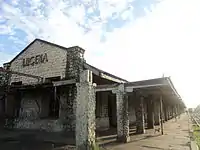
- Lucena – South City Proper, Lucena City
- Mayao – Brgy. Mayao, Lucena (defunct flag stop)
- Castillo – Brgy. Castillo, Pagbilao
- Pagbilao – Pagbilao
- Pinagbayanan – Brgy. Pinagbayanan, Pagbilao
- Palsabangon – Brgy. Ibabang Palsabangon, Pagbilao( flagstop)
- Binahaan – Brgy. Binahaan, Pagbilao
- Malicboy – Brgy. Malicboy, Pagbilao
- Guintong – Brgy. Guinto, Pagbilao
- Sipa – Brgy. Sipa, Pagbilao
- Hinguiwin – Brgy. Hinguiwin, Padre Burgos
- Padre Burgos (Laguimanoc) – Padre Burgos
- Marao – Brgy. Marao, Padre Burgos
- Pinaninding – Brgy. Danlagan, Padre Burgos
- San Isidro (Yawe) – Brgy. San Isidro, Padre Burgos
- Walay – Brgy. Walay, Padre Burgos
- Cabuyao – Brgy. Cabuyao Sur, Padre Burgos (flag stop)
- Agdangan – Agdangan
- Panaon – Brgy. Panaon, Unisan
- Poctol – Brgy. Poctol, Unisan
- Atimonan (Summit) – Brgy. Inalig, Atimonan
- Plaridel (Siain) – Plaridel
- Inaclagan – Brgy. Inaclagan, Gumaca
- Villa Bota – Brgy. Villa Bota, Gumaca
- Gumaca – Gumaca
- Panikihan – Brgy. Panikihan, Gumaca
- Bamban – Brgy. Bamban, Gumaca
- Hagakhakin – Brgy. Hagakhakin, Gumaca
- San Vicente – Brgy. San Vicente, Gumaca
- Pansol – Brgy. Pansol, Lopez, (defunct flag stop, opened in 1923)
- Lopez – Lopez
- Santa Lucia – Brgy. Santa Lucia, Lopez
- Hondagua – Brgy. Hondagua, Lopez
- Calauag – Brgy. Santa Maria, Calauag
- Sumulong – Brgy. Sumulong, Calauag
- Santo Domingo – Brgy. Santo Domingo, Calauag
- Danlagan – Brgy. Danlagan Reserva, Guinayangan (destroyed in 1945)
- Aloneros – Brgy. Aloneros, Guinayangan
- Cabugwang – Brgy. Cabugwang, Tagkawayan
- Manato – Brgy. Manato station, Tagkawayan
- New Aloneros – Brgy. Manato station, Tagkawayan
- Mangayao – Brgy. Mangayao, Tagkawayan
- Katimo – Brgy. Katimo, Tagkawayan
- Buyabod – Brgy. Buyabod, Tagkawayan
- Kinatakutan – Brgy. Kinatakutan, Tagkawayan
- Laurel – Brgy. Laurel, Tagkawayan
- Aliji – Brgy. Aliji, Tagkawayan
- Morato – Brgy. Morato, Tagkawayan
- Tagkawayan – Tagkawayan
Camarines Sur
- Pasay (Pasay C.S.) – Brgy. Pasay, Del Gallego
- Del Gallego – Del Gallego
- San Juan – Brgy. San Juan, Del Gallego
- Sinuknipan – Brgy. Sinuknipan, Del Gallego
- Catabangan (Godofredo Reyes Sr.) – Brgy. Godofredo Reyes Sr. (Catabangan Junction), Ragay
- Port Junction – Brgy. Port Junction, Ragay
- Fort Simeon (Pugod) – Brgy. Fort Simeon, Ragay
- Liboro – Brgy. Liboro, Ragay
- Ragay – Ragay
- Banga Caves – Brgy. Banga Caves, Ragay
- Del Rosario – Brgy. Colacling (Del Rosario), Lupi (flag stop)
- Lupi Viejo – Lupi (flag stop)
- Lupi Nuevo – Brgy. Tapi, Lupi
- Manangle – Brgy. Manangle, Sipocot
- Sipocot – Sipocot
- Awayan – Brgy. Awayan, Sipocot (flag stop)
- Mantalisay – Brgy. Mantalisay, Libmanan (flag stop)
- Camambugan – Brgy. Camambugan, Libmanan (flag stop)
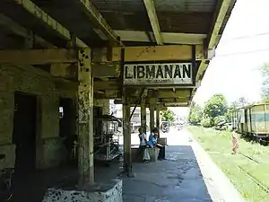
- Libmanan – Libmanan
- Rongos – Brgy. Rongos, Libmanan [flag stop]
- Malansad – Brgy. Malansad, Libmanan [flag stop]
- Mambulo – Brgy. Mambulo Viejo, Libmanan (flag stop)
- Pamplona – Pamplona
- Burabod – Brgy. Burabod, Pamplona (flag stop)
- Sampaloc – Brgy. Sampaloc, Gainza (flag stop)
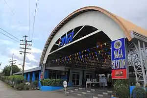
- Naga – Brgy. Triangulo, Naga City
- San Antonio (San Antonio C.S.) – Brgy. San Antonio, Milaor
- Maycatmon – Brgy. Maycatmon, Milaor
- San Jose – Brgy. San Jose, Pili
- Pili – Pili
- Bula – Bula
- Agdangan – Brgy. Agdangan, Baao
- Baao – Baao
- Iriga – Iriga City
- Lourdes Old – Brgy. Lourdes Old, Nabua (flag stop)
- Bato – Bato
Albay
- Matacon – Brgy. Matacon, Polangui (flag stop)
- Santicon – Brgy. Santicon, Polangui
- Apad – Brgy. Apad, Polangui
- Polangui – Polangui
- Oas – Oas (flag stop)
- Ligao – Ligao City
- Guinobatan – Brgy. Masarawag, Guinobatan
- Travesia – Brgy. Travesia, Guinobatan
- Camalig – Camalig [Abandoned because of a diversion line built by the PNR to alleviate the original high gradient, lava affected section between Camalig and Daraga]
- Daraga – Brgy. Sagpon, Daraga
- Washington Drive – Brgy. 16 Kawit-East Washington Drive, Legazpi (flagstop)
- Legazpi (Legaspi) – Legazpi City (Terminus for the Legazpi-Tabaco Line)
Abandoned and inactive branches
Tarlac-San Jose branch
An abandoned branch line serving Tarlac and Nueva Ecija. This line was also planned to be extended to Cagayan province, with services linking almost all the provinces in the Cagayan Valley. PNR has requested for a feasibility study for the revival of the line, to be connected to the North-South Commuter Railway project.[4]
Tarlac
- Tarlac City – Tarlac City
- Balibago T. – Balibago, Tarlac (flag stop)
- Victoria – Victoria (ruins)
- Canarem – Canarem, Victoria (flag stop)
Nueva Ecija
- Subol – Brgy. Subol, Guimba
- Bantug – Brgy. Bantug, Guimba
- Guimba – Guimba (ruins)
- Matarano – Brgy. Maturanoc, Gumimba
- Cabaruan – Brgy. Cabaruan, Guimba
- Gabaldon – Brgy. Gabaldon, Muñoz
- Palosapis – Brgy. Palusapis, Muñoz
- Muñoz (Muñoz-Talavera) – Muñoz
- Central Luzon Agricultural College – Central Luzon State University, Muñoz
- San Jose – San Jose (ruins)
Cagayan
- Enrile – Enrile
- Tuguegarao (proposed) – Tuguegarao
Santa Mesa-Antipolo branch
Ceased operations when the San Juan River Bridge collapsed. Remains of the old railroad tracks from the old line are still present. The piers of the San Juan River bridge were still standing until they were demolished in 2018 due to the Skyway Stage 3 traversing through the river. It would be only feasible in the future to reactive just the Sta. Mesa-Mandaluyong parts of the line and the bridge rebuilt, with possible elevated tracks on the final segment to the Guadalupe station, which links the PNR to EDSA and MRT Line 3 (the nearest stations are the Guadalupe Station in Makati and Boni Avenue Station in Mandaluyong).
Manila
- Santa Mesa – Bacood, Santa Mesa
- Cordillera – Bacood, Santa Mesa (flag stop, opened in 1974)
- Bagumbayan – Bacood, Santa Mesa (flag stop, opened in 1974)
Mandaluyong
- Mandaluyong (San Felipe Neri) – Brgy. Daang Bakal
- Magalona – Brgy. Daang Bakal (flag stop, opened in 1974)
- A. Bonifacio – Brgy. Addition Hills (flag stop, opened in 1974)
- Welfareville – Brgy. Addition Hills
- Boni Avenue – Brgy. Old Zañiga (flag stop, opened in 1974)
- Zaniga (Saniga) – Brgy. Old Zañiga (flag stop, opened in 1974)
- Hulo (San Pedro Macati) – Brgy. Hulo, near San Francisco Street (flag stop)
- Guadalupe (Barangka) – Brgy. Barangka Ilaya, near EDSA, terminus of the line (now serves as the Mayor Neptali Gonzales Jr. Basketball Gymnnasium; opened in 1927)
Pasig
- Fort McKinley – Brgy. Kapitolyo
- Pineda – Brgy. Pineda, near Barangay Hall (flag stop, opened in 1927)
- Bagong Ilog – Brgy. Bagong Ilog (flag stop, opened in 1928)
- Pasig – Pasig
- Rosario – Brgy. Rosario (terminus for the Rosario-Montalban line)
Rizal
- Cainta – Cainta (opened in 1925)
- Taytay – Taytay (rail yard now serves as a market)
- Hinulugang Taktak – Hinulugang Taktak, Antipolo
- Antipolo – Antipolo (corner of Sumulong Memorial Circle and San Jose St.)
Balagtas-Cabanatuan branch
This line is one of the branch lines that were abandoned after World War II. The line was reopened in 1969; however, it was once again left unoperational in 1980. If reactivated, it will serve thousands of people and tourists as well as provide freight services to the provinces of Bulacan and Nueva Ecija. PNR has requested a feasibility study for a planned revival as a northeast commuter line to Makati, as part of the process for getting the final nod on the project.[4]
Bulacan
- Balagtas (Bigaa) – Balagtas
- Malis – Brgy. Malis, Guiguinto (also known as Tiaong G.)
- Plaridel – Plaridel
- Pulilan – Pulilan
- Baliuag – Baliuag
- Maasim – Brgy. Maasim, San Ildefonso
- San Ildefonso – San Ildefonso
- San Miguel (San Miguel de Mayumo) – San Miguel
- Pinambaran – Brgy. Pinambaran, San Miguel
Nueva Ecija
- Baluarte – Baluarte, Gapan
- San Isidro – San Isidro
- Gapan – Gapan
- Peñaranda – Peñaranda
- Papaya – General Tinio
- San Leonardo – San Leonardo
- Santa Rosa – Santa Rosa
- Cabanatuan – Cabanatuan
Rosario-Montalban branch
An abandoned branch line which used to serve the cities of Pasig, Marikina, and the province of Rizal.
Pasig
- Rosario – Brgy. Rosario
Marikina
- Marikina (Mariquina) – Marikina (still existing)
- Santo Niño – Brgy. Santo Niño (flag stop, opened in 1927)
- Bayanbayanan – Brgy. Bayanbayanan
- Nangka – Brgy. Nangka (flag stop, opened in 1927)
Fort Stotsenburg-Dau branch
A line from Fort Stotsenburg in Angeles to Mabalacat, Pampanga
Dau-Magalang branch
An abandoned branch line from Dau to Magalang.
- Dau – Brgy. Dau, Mabalacat, Pampanga
- Sapang Biabas – Brgy. Sapang Biabas, Mabalacat
- Bical – Brgy. Bical, Mabalacat
- Magalang – Brgy. San Pedro II, Magalang (still existing)
Nielson Field branch
Abandoned after Nielson Field was closed.
- Pasay Road (Culi-culi/Pio Del Pilar) – Brgy. Pio del Pilar, Makati
- Legazpi Village – Legazpi Village, Brgy. San Lorenzo (near Nielson Field)
Legazpi-Tabaco branch
Abandoned line that served passengers and cargo going to Tabaco City and its harbor.
Aringay–Asin branch
This was a 40.4 km (25.1 mi) spur line meant to connect Aringay, La Union with Baguio City in Benguet. However, tracks actually terminated in Asin in Tuba, Benguet. Construction on the final section leading to Baguio was halted during World War I. The Salapak Tunnel, originally meant for the line, was used during World War II as the regional headquarters of the Imperial Japanese Army. During the PNR era, the right-of-way has been sold to residents and became either roads or farmland. The local government of Aringay also proposed to the PNR to convert the Salapak Tunnel into an ecotourism zone, but PNR turned down the request since there are plans to restore the tunnel in the future, referring to the PNR North Long Haul service.[5]
- Aringay – Aringay, La Union
- Asin – Tuba, Benguet (completed section)
- Baguio – Baguio (proposed)
San Fabian-Camp One branch
This is a line to Camp One, Rosario, La Union. It was the first railroad project attempting to reach Baguio, abandoned however in 1914. A remnant is the triangle junction which was part of the rail tracks, which are now being used as roads.
- San Fabian – San Fabian, Pangasinan
- Binday – Brgy. Binday, San Fabian
- Alava – Brgy. Alava, San Fabian
- Camp One – Brgy. Camp One, Rosario, La Union
Arayat-Carmen branch
If reactivated, it would serve as a tourist line linking the PNR network to the Mount Arayat National Park and as a faster access to western parts of Pampanga, northern Bataan, southern Zambales and the Subic Bay Freeport Zone, with the possible construction in the future of a rail line linking the two economic zones.
- Arayat – Arayat, Pampanga
- Sta. Ana – Brgy. Sta. Ana, Mexico, Pampanga
- Mexico – Mexico
- San Fernando – San Fernando, Pampanga
- Pasudeco – Brgy. Santo Niño, San Fernando
- Bacolor – Bacolor, Pampanga
- Cabetican – Brgy. Cabetican, Bacolor
- Betis – Brgy. Betis, Guagua
- Guagua – Guagua, Pampanga
- Santa Monica – Brgy. Santa Monica, Lubao
- Lubao – Lubao, Pampanga
- San Matias – Brgy. San Matias, Lubao
- Concepcion – Brgy. Concepcion, Lubao
- San Francisco – Brgy. San Francisco, Lubao
- Floridablanca – Floridablanca, Pampanga
- Paguiruan – Brgy. Paguiruan, Floridablanca
- Del Carmen (Carmen) – Brgy. Del Carmen, Floridablanca
Tayug branch
If reactivated, the line will serve residents and freight in Pangasinan, Nueva Ecija, and Tarlac.
Pangasinan
- Calanatuan – Brgy. Calanutan, Rosales
- Rosales – Rosales
- Balungao – Balungao
- San Leon – Brgy. San Leon, Balungao
- Cabalitian – Brgy. Cabalitian, Umingan
- San Pedro – Brgy. San Pedro, San Quintin (flag stop, still existing)
- San Quintin – San Quintin
San Pablo-Malvar branch
Branch line from San Pablo, Laguna to Malvar, Batangas. It was abandoned after the Los Baños to San Pablo route was built. If reopened, it would serve as an alternative to the main line.
- San Pablo – San Pablo City
- Santa Monica – Brgy. Santa Monica, San Pablo
- Magampon – San Pablo
- Alaminos – Alaminos, Laguna
- San Andres – Brgy. San Andres, Alaminos
- San Joaquin – Brgy. San Joaquin, Santo Tomas City, Batangas
- Camballao – Brgy. San Francisco, Santo Tomas (opened in 1928)
- Salvarrol – Brgy. San Francisco, Santo Tomas
- Malvar (Luta) – Malvar, Batangas
Paniqui-Camiling branch
Abandoned tram line that was operated by the Tarlac Railway Company.
Lingayen-Camiling branch
Cancelled during the planning stages. The route was supposed to be from Lingayen, Pangasinan to Camiling, Tarlac.
Damortis-Tuba branch
Branch line abandoned before the bed was completed and before any bridges had been constructed, the only remains of this line are the two railroad tunnels in Asin Road.
- Damortis – Brgy. Damortis, Rosario, La Union
- Tuba (proposed) – Tuba, Benguet
Caba-Galiano branch
Abandoned before the bed was completed and before any bridges had been constructed
- Caba (proposed) – Caba
- Kapangan (proposed) – Kapangan, Benguet
- La Trinidad (proposed) – La Trinidad, Benguet
- Galiano (proposed) – Atok, Benguet
Paco-Naic branch
Very few, if not none, of the original line exists today due to the path occupied presently by the Ninoy Aquino International Airport and various developments since the line's closure.
- Paco – Paco, Manila
- Singalong – Brgy. 730 Zone 79, Vito Cruz St., Malate, Manila
- Pasay – Brgy. 64 Zone 8 Pasay City [near the Santa Clara de Montefalco church]
- Maricaban (Tabon) – Maricaban, Pasay
- Pildera – Airport Rd. Parañaque City (the closest station to NAIA)
- Parañaque – Brgy. San Dionisio. Parañaque
- Las Piñas – Brgy. Manuyo Uno, Las Piñas City
- Aromahan – Brgy. Pamplona Uno, Las Piñas
- Zapote – Brgy. Zapote IV, Bacoor, Cavite
- Panapaan – Brgy. Panapaan III, Bacoor
- Bacoor – Poblacion, Bacoor, Cavite
- Binacayan – Brgy. Binacayan, Kawit, Cavite
- Gahak – Brgy. Gahak, Kawit
- Cavite El Viejo – Kawit, Cavite [formerly Cavite El Viejo]
- San Juan – Brgy. San Juan, Noveleta
- Noveleta – Noveleta, Cavite
- Salinas (Rosario) – Rosario, Cavite
- Tanza – Tanza, Cavite
- Naic – Brgy. Ibayong Estacion, Naic, Cavite
San Pedro-Carmona branch
This is the last branch line that was used by PNR up to early 2000s. In 2010, the land area of the station in San Jose (now considered on the tip and under the jurisdiction of GMA Cavite between San Pedro and Carmona), was allegedly re-leased to the private sector and the old rails were dismantled halfway up to Olympia Street in Pacita Complex. The old rails still exists from Chrysanthemum Station up to Crismor Ave. in Elvinda near the old San Pedro Station and is at least still in use by the squatter's trolleys. This 3.9-kilometer line was opened in 1973.
Though inactive at present, PNR intends to reintroduce services to this branch line sometime in 2019, and a potential repair work would soon begin in preparation for the line's reopening. DOTr officials inspected the line on August 19, 2018 to review its conditions in readiness for the resumption of operations.[6]
Cavite branch
An abandoned branch line serving Cavite City and parts of Noveleta.
- Caridad – Brgy. Caridad, Cavite City
- San Roque – Brgy. San Roque, Cavite City
- Cavite – Cavite City
Pandacan-Isla Provisor branch
Also known as the Santibañez line. This line had spurs leading to Isla Provisor, Luzon Brokerage Company, the closed Pandacan Oil Depot and the Johnson Picket Rope Company. It ends in what is now the Tabacalera Compound today. The bridge route's crossing in Pasig River is a mechanical swing bridge built to allow bigger ships to pass through. Today, not only is the mechanical component of the bridge nonfunctional, but the bridge itself cannot turn anymore due to the Pandacan Bridge built very close to its turning radius. The very bridge itself is still in use by trains, and occasionally by rickshaws and railskates.
Rongos branch
A 1.7-kilometer line connecting the former Rongos wharf in the Bicol River for construction purposes. Dismantled after the completion of the South Line in 1938.
- Rongos – Brgy. Rongos, Libmanan [flag stop]
- Rongos Wharf – Brgy. Rongos, Libmanan
UP Los Baños-Santa Cruz branch
This inactive line, when reactivated, could serve passengers and freight in the Eastern parts of Laguna, while providing a faster access to tourist and historical destinations within the province.
Laguna
- College – Brgy. Batong Malake, Los Baños
- Bay – Bay
- Bangyas – Brgy. Bangyas, Calauan
- Victoria (Dayap) – Victoria
- Manaol – Brgy. Manaol, Nagcarlan
- Banca-Banca – Brgy. Banca-Banca, Nagcarlan
- Calumpang – Brgy. Calumpang, Nagcarlan
- Magdalena – Magdalena
- Cabanbanan (Buboy) – Brgy. Pagsawitan, Santa Cruz
- Pagsawitan – Brgy. Pagsawitan, Santa Cruz
- Santa Cruz – near the Laguna Provincial Capitol, Santa Cruz
- Pagsanjan – Brgy. Maulawin, Pagsanjan
Calamba-Bauan branch
Part of the Long-Haul Railway project, it includes the construction of a new line to Bicol. The Calamba-Batangas City section of the branch will be reconstructed into a new single-track line that will be expanded to two when capacity is needed to be expanded.
Laguna
- Calamba – Brgy. 1, Calamba City
- Makiling – Brgy. Makiling, Calamba
Batangas
- Santo Tomas – Santo Tomas
- Tanauan – Tanauan City
- Malvar (Luta) – Brgy. Poblacion, Malvar, Batangas [Terminus for the San Pablo-Malvar Line]
- Lipa – Lipa City
- San Jose – San Jose, Batangas
- Batangas – near the Batangas Provincial Capitol
- Bauan – Bauan
Mamatid-Buntog branch
This branch line, currently inactive, is the nearest rail link to the Nuvali residential township of Ayala Land, which extends to Calamba City to the south, as well as to Tagaytay. It is also a potential branch line for a revived freight service from Metro Manila in the future, since a multimodal freight terminal was from the 1990s up to 2001 served by this line via container trains from the capital region.
- Mamatid – Mamatid, Cabuyao City
- Majapa – Brgy. Majapa, Calamba, Laguna
- Canlubang – Canlubang, Calamba
- Locomotive – Canlubang, Calamba
- Buntog – Sitio Buntog, Canlubang, Calamba
Cabuyao branch
The only remnant of this line is a railroad overpass crossing the South Luzon Expressway near Eton City Exit, claimed to be part of Cabuyao.
See also
References
- "17 stations of Manila-Clark Railway announced". Rappler. Retrieved October 13, 2018.
- Orejas, Tonette. "Death March glimpses in old train station". Retrieved October 13, 2018.
- "What Happened to Bulacan's Old Train Stations? – Finding Jing". Finding Jing. January 6, 2017. Retrieved October 12, 2018.
- Share; Twitter. "PNR asks for feasibility of Cabanatuan-Makati line". www.pna.gov.ph. Retrieved January 26, 2019.
- "The saga of Aringay rail line". Philippine Daily Inquirer. November 26, 2014. Retrieved August 18, 2020.
- https://www.facebook.com/DOTrPH/posts/1186365421502592