Transportation in Metro Manila
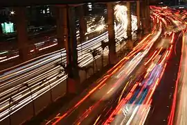
The transportation system in Metro Manila is currently inadequate to accommodate the mobility and other basic needs of an densely populated metropolis, the result of many factors and problems that the government has failed to provide or address. Metro Manila exists in a state of near-permanent gridlock, with people and goods trapped by the very system that is supposed to move them quickly and efficiently.[1] Because of the insufficient public transportation network, car ownership has risen dramatically, contributing further to the congestion that occurs at all times of day on the road. Filipinos view cars as not just tools to get them to where they need to go; they also believe that their car is an important symbol of the success they have achieved in life.[2] In recent years, however, the Philippine government has been pushing to improve the mass transit system through various infrastructure projects,[3] hoping to solve the interlinked problems of transportation, land use and environment.[4]
_(14765708731).jpg.webp)
Since the government shifted the infrastructure needs of Metro Manila into sharper focus with the "Build Build Build" program of the Duterte administration, traffic relief will gradually become a reality. The program aims to usher in "a golden age of infrastructure" in the country, with most of the 75 projects lined up and in various stages of completion directly impacting the Greater Capital Region, composed of Metro Manila, Region 3 (Central Luzon) and Region 4A (Calabarzon).[5]
Manila, being a major city, offers various transportation options: light metro, rapid transit, commuter rail, bus, jeepney, UV Express and taxicab. The most famous of these modes is the public jeepney, which has been in use since the years immediately after World War II. Auto rickshaws (referred to as "tricycles" in the Philippines) and pedicabs are used for short distances. Because Metro Manila is one of the most heavily-populated cities in the world, it is now served by rapid mass rail transit. More train lines are planned and under construction.
Infrastructure
Roads
(2018-02-07).jpg.webp)
_04.jpg.webp)
The existing main roads of Metro Manila are organized around a set of Radial and Circumferential roads established during the American period in the country's history. All R roads originate from various points in the city of Manila and radiate south, east or north to the other cities in Metro Manila and end farther out into the Greater Capital Region and beyond. In a similar way, all C roads run in a half circle that begins and ends at Manila Bay, with Manila at the innermost circle.
The only major thoroughfare in Metro Manila not included in the arterial road system is Dr. Arcadio Santos Avenue (formerly Sucat Road) in Paranaque, designated as Highway N63.
Radial roads
- Radial Road 1 - Anchored on Roxas Blvd, from Bonifacio Drive up to and including Cavitex in Kawit, Cavite. A portion of Roxas Blvd is designated as Highway N61.
- Radial Road 2 - Anchored on Taft Avenue, from the Lagusnilad Underpass in front of Manila City Hall up to and including Aguinaldo Highway in Cavite. Part of the road is designated Highway N62.
- Radial Road 3 - Anchored on Osmena Highway/SLEX, from Quirino Avenue through to the Santo Tomas exit in Batangas.
- Radial Road 4 - An incomplete road, it starts from Pedro Gil Street through Makati where the main part of the road is J.P.Rizal Avenue. From there, the road is undefined until it reaches Pateros and Taytay before ending at the Manggahan Floodway.
- Radial Road 5 - Anchored on Shaw Boulevard and Ortigas Avenue, from V. Mapa Street up to and including the Manila East Road. Part of the road is designated as Highway N60.
- Radial Road 6 - Anchored on Magsaysay Boulevard and Aurora Boulevard, from Legarda Street up to and including the Marikina-Infanta Highway. The road is designated as either Highway N59 or N180 .
- Radial Road 7 - Anchored on Espana Boulevard, Quezon Avenue and Commonwealth Avenue, from Lerma up to and including Quirino Highway to Bulacan.
- Radial Road 8 - Anchored on Dimasalang Street and NLEX, from Quiapo to Clark in Pampanga.
- Radial Road 9 - Anchored on Rizal Avenue, from Carriedo to MacArthur Highway in Rosario, Pangasinan.
- Radial Road 10 - Anchored on Marcos Road in Tondo, from the Del Pan Bridge up to the intersection with C-4.
Circumferential roads
- Circumferential Road 1 - Anchored on Recto Avenue and Ayala Avenue, from Tondo to the Luneta Park.
- Circumferential Road 2 - Anchored on Lacson and Quirino avenues, from Tondo to Roxas Boulevard.
- Circumferential Road 3 - An incomplete road, anchored on Araneta Avenue, from R-10 in Navotas to Buendia Avenue in Pasay, with the broken segment in Makati.
- Circumferential Road 4 - Dominated by the whole length of EDSA, from the R-10 intersection to the Mall of Asia in Pasay.
- Circumferential Road 5 - Segments are incomplete but under construction (as of Feb. 2019), from NLEX Karuhatan segment to the FTI area in Taguig, and ultimately to the Coastal Road (Cavitex) in Las Pinas.
- Circumferential Road 6 - The beltway of Metro Manila, it will be anchored by the Southeast Metro Manila Expressway (also known as Skyway Stage 4[6]) currently under construction, from MacArthur Highway in Marilao, Bulacan to Kawit, Cavite.
Expressways
(2017-05-10).jpg.webp)

Expressways are controlled-access highways, with crossing traffic limited to overpasses, underpasses, and interchanges. Metro Manila is served by the following expressways:
There are expressways under construction or proposed. These include:
- Southeast Metro Manila Expressway[7]
- C-5 South Link Expressway
- C-5 Expressway
- Pasig River Expressway
- Metro Manila Skybridge[8]
- Manila–Quezon Expressway
- R-7 Expressway
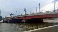
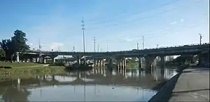
Bridges

(2017-08-20).jpg.webp)
(2018-06-04).jpg.webp)

There are a total of 33 bridge spans in Metro Manila that cross the Pasig and Marikina rivers, including one tollway bridge, four rail-only bridges, the Line 1, Line 2, Line 3 and the PNR tracks.
Pasig River Bridges
The bridges are listed below in west to east order, with the first bridge nearest to the mouth of the Pasig River into Manila Bay.
- Roxas Bridge - formerly called Del Pan Bridge (San Nicolas to Port Area)
- Jones Bridge - formerly called Puente de España (Binondo to Ermita)
- MacArthur Bridge (Sta. Cruz to Ermita)
- Line 1 (Carriedo Station to Central Station)
- Quezon Bridge (Quiapo to Ermita)
- Ayala Bridge (San Miguel to Ermita)
- Mabini Bridge - formerly called Nagtahan Bridge (Sta. Mesa to Pandacan)
- Philippine National Railways (Santa Mesa Station to Pandacan Station)
- Padre Zamora Bridge formerly called Pandacan Bridge (Sta.Mesa to Pandacan)
- Skyway (Nagtahan Interchange to Aurora Boulevard Interchange)
- Lambingan Bridge (Sta. Ana)
- Makati-Mandaluyong Bridge
- Line 3 (Boni station to Guadalupe Station)
- Guadalupe Bridge (Makati to Mandaluyong)
- C.P. Garcia Bridge (Makati to Pasig)
- Kaunlaran Bridge (Pasig)
- Bambang Bridge (Pasig)
- Kalawaan Bridge (Pasig)
- Napindan Bridge (Pasig to Taguig)
Two new bridges are under construction:
- Binondo–Intramuros Bridge[9]
- BGC-Ortigas Link Bridge
- Estrella–Pantaleon Bridge[9] (reconstruction)
Marikina River Bridges
The bridges listed below are those located in Metro Manila crossing the Marikina River (listed towards the confluence with the Pasig River in a north to south order):
- Batasan-San Mateo Bridge (Quezon City to San Mateo, Rizal)
- Gil Fernando Bridge (Marikina)
- A. Bonifacio Bridge (Marikina)
- Marcos Bridge (Marikina)
- Line 2 (Santolan Station to Katipunan Station)
- Diosdado Macapagal Bridge (Quezon City to Marikina)
- Caruncho Bridge (Quezon City to Pasig)
- Rosario Bridge (Pasig)
- Sandoval Bridge (Pasig)
- Kaginhawaan Bridge (Pasig)
- Vargas Bridge (Pasig)
- Sta. Rosa de Lima Bridge (Pasig)
Public transport
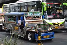
Manila, being a major city, offers various transportation options. The most famous of these modes is the public jeepney, which has been in use since the years immediately after World War II. Buses, air-conditioned metered taxi, and Tamaraw FX mini-vans are also popular forms of transportation. Auto rickshaws (referred to as "tricycles" in the Philippines) and pedicabs are used for short distances. In some areas, especially in Divisoria and large public markets, two-stroke motors are fitted in the pedicabs and are used for goods transport. Regardless of modernity, horse-drawn calesas are still used in the streets of Binondo and Intramuros. Buses, taxis and trains are also other important means of public transportation in the metropolis. The metropolis is served by the Manila Light Rail Transit System (Line 1 and Line 2), the Manila Metro Rail Transit System (Line 3) and the Philippine National Railways (PNR). More train lines are planned or under construction.
Grab operates in Metro Manila.[10]
Jeepneys

Jeepneys are the most popular mode of public transportation in the Philippines, they have also become a ubiquitous symbol of the Philippine culture.[11] According to the Metro Manila Dream Plan report by the Japan International Cooperation Agency (JICA), a survey made in 2007 came out with 48,366 public utility jeepneys plying some 600 routes nationwide, with 61% serving the Greater Capital Region, which includes Metro Manila. In 2000, jeepneys and tricycles topped all modes of travel in Metro Manila at 46%, before light rail became popular, followed by buses at 24% and private vehicles at 21%.[12] At present, there are around 270,000 franchised jeepney units on the road across the country, with some 75,000 units in Metro Manila alone.[13]
In 2016, the Department of Transportation and Communications imposed an age limit on jeepneys of 15 years, with older jeepneys starting to be phased out.[14] Many jeepney operators oppose the phase-out,[15] and politicians urged the government to drop the jeepney modernization program.[16] As part of the PUV modernization program all new and existing vehicles must be fitted with a tap card system which allows commuters to pay for their trip.[17] The system would enable journey details to be recorded and the appropriate fare deducted from the stored value on the card.[18]
Buses
Aside from dilapidated jeepneys, public utility buses (PUBs) are the bane of Metro Manila's congested roads, due to their numbers, their sheer physical size, and the methods of bus drivers and conductors of loading and unloading passengers. On any given day, some 3 million vehicles pass Metro Manila's main circumferential artery, EDSA or C-4. Of the total, about 140,000 are buses, according to an article by the Philippine Center for Investigative Journalism (PCIJ).[19] "The boorish behavior of many public buses -- as well as the fact that far too many of them are on the road -- has gotten worse through the years." Figures from the LTFRB indicate that there are about 13,000 buses operating in Metro Manila run by 1,200 operators, about half of them using EDSA. In response to this, the Metropolitan Manila Development Authority (MMDA) ordered the removal of all provincial bus terminals along EDSA by 2019.[20] On June 1, 2020, MMDA instituted the EDSA Busway.
Manila has many metrobus companies such as Erjohn & Almark, Baclaran Metro Link and AC Trans. These use old Japanese buses (especially Isuzu or Nissan Diesel) converted to left-hand drive while the prevalence of surplus South Korean buses (like Daewoo and Kia) which are originally left hand is also popular nowadays. New buses on the other hand are also now popular with the influx of Chinese-made buses.
Franchised city buses are:
Intermodal terminals
| Name | City | Rail line | Modes | Notes |
|---|---|---|---|---|
| Parañaque Integrated Terminal Exchange (PITX) | Parañaque | LRT Line 1 | Bus, jeepney, taxi and UV Express | Opened on November 5, 2018. Connection to LRT-1 under construction. |
| Taguig Integrated Terminal Exchange (Southern Integrated Transport Exchange, Southern ITX) | Taguig | Metro Manila Subway |
Bus, jeepney, taxi, and UV Express |
Under construction |
| Valenzuela Gateway Complex (VGC) | Valenzuela | N/A | Tricycles, buses, jeepneys and UV Express | |
| North Avenue Grand Central Station (Unified Grand Central Station) | Quezon City | LRT Line 1 | To be announced | Area A under construction, Areas B and C approved |
Rail/Bus Transfer Stations
Source: LTFRB; Google Maps. Listed in the order of interchange with Lines 1,2,3 and PNR Commuter. Note: Rail lines and facilities in italics are proposed and/or under construction.
| Location Area | City | Rail Lines | Bus Transfers Nearby | Notes |
|---|---|---|---|---|
| North EDSA Common Station | Quezon City |
|
MMDA North EDSA provincial bus terminal | |
| EDSA / Balintawak | Quezon City | Line 1 Balintawak Sta. |
|
Provincial bus terminals in nearby locations |
| Monumento | Caloocan | Line 1 Monumento Sta. |
|
Provincial bus terminals in nearby locations |
| Rizal Ave / 5th Avenue | Caloocan | Line 1 – 5th Ave Sta. |
|
Baliwag Transit provincial bus station (2nd Ave) |
| Rizal Ave / Blumentritt | Manila |
|
|
|
| Rizal Ave / Recto Ave | Manila |
|
|
Provincial bus terminals in nearby locations |
| Plaza Lawton | Manila |
|
|
Plaza Lawton provincial bus terminal |
| Taft / Gil Puyat | Pasay | Line 1 Gil Puyat Sta. |
|
Buendia provincial bus terminals (various) |
| Taft / EDSA | Pasay |
|
|
Pasay provincial bus terminals in nearby locations |
| Roxas Blvd / Redemptorist Rd. | Paranaque | Line 1 Redemptorist Sta. |
|
Provincial bus terminals in nearby locations |
| Roxas Blvd / Airport Road | Paranaque | Line 1 MIA Sta. |
|
Provincial bus routes at the Southwest Integrated Provincial Terminal (SWIPTT) |
| Roxas Blvd / Cavitex | Paranaque | Line 1 Asia World Sta. |
|
New facility PITX presently building up capacity |
| Recto / Legarda | Manila | Line 2 Legarda Sta. |
|
Raymond Transport provincial bus terminal |
| Magsaysay Blvd / Pureza | Manila |
|
|
A&B Liner provincial bus terminal |
| Magsaysay Blvd / V. Mapa | Manila | Line 2 V. Mapa Sta. |
|
|
| Aurora Blvd / J. Ruiz St. | QC | Line 2 J. Ruiz Sta. |
|
Penafrancia Tours provincial bus stop (QC-Legazpi) |
| Aurora Blvd / Cubao | QC |
|
|
Araneta Center/Cubao provincial bus terminals (various) |
| Aurora Ave / Anonas | QC |
|
|
|
| Marilaque Hwy | Antipolo, Rizal | Line 2 Emerald Sta. |
|
Emerald Station under construction |
| Marilaque Hwy | Antipolo, Rizal | Line 2 Masinag Sta. |
|
Masinag Station under construction |
| EDSA / Quezon Ave. | Quezon City |
|
|
Quezon Ave. provincial bus station |
| EDSA / Kamuning Rd. | QC | Line 3 Kamuning Sta. |
|
Timog Ave./Kamuning/Kamias provincial terminals (various) |
| EDSA / Santolan | QC | Line 3 Santolan Sta. |
|
|
| EDSA / Ortigas Ave. | Pasig | Line 3 Ortigas Sta. |
|
Ortigas Ave. Provincial bus terminal |
| EDSA / Shaw Blvd. | Mandaluyong | Line 3 Shaw Blvd Sta. |
|
Note |
| EDSA / Guadalupe | Makati |
|
|
|
| EDSA / Buendia Ave. | Makati | Line 3 Buendia Sta. |
|
|
| EDSA / Ayala Ave. | Makati | Line 3 Ayala Sta. |
|
|
| EDSA/Magallanes | Makati |
|
|
|
| Tutuban Main Terminal | Manila | PNR Metro Commuter |
|
Victory Liner provincial bus terminal |
| Espana PNR Station | Manila | PNR South Metro Commuter |
|
Dimple Star provincial bus station |
| Osmena Hwy / Buendia Ave. | Pasay/Makati | PNR Metro Commuter Dela Rosa Sta. |
|
|
| SLEX / Sales Rd-Lawton Ave. | Pasay | PNR Metro Commuter Nichols Sta. |
| |
| SLEX / C-5 | Taguig |
|
|
Under construction |
| SLEX / Sucat Road | Paranaque | PNR Metro Commuter Sucat Sta. |
|
|
| SLEX / Alabang | Muntinlupa | PNR Metro Commuter Alabang Sta. |
|
Mass transit
Rail transport


The development of mass transit had its inception in the 1970 when the Philippine National Railways offered among its services the first Metro Commuter line. Line 1, which is the first rail line operated by the Light Rail Transit Authority, a government corporation, opened in 1984, making it the first rapid rail transport in Southeast Asia. It was followed in 1999 by Line 3 along EDSA operated by the private company, Metro Rail Transit Corporation, before Line 2 was completed in 2003. Together, these four lines run by three different entities bear the brunt of providing the metropolis with rail as a faster alternative mode of transport other than buses and jeepneys. More rapid transit rail lines are in the planning stages or under construction as of 2019.
As of 2018, there were two different rapid transit systems in Metro Manila: the Manila Light Rail Transit System, or the LRTA System, and the Manila Metro Rail Transit System, or the MRTC System. The Green Line (Line 1) and the Blue Line (Line 2) form the LRTA network, while the Yellow Line (Line 3) forms the MRTC network, with 31 stations on the LRTA and 13 stations on the MRTC. Four more lines are proposed and would connect Metro Manila to the provinces of Bulacan, Cavite, Laguna and Rizal upon their completion.
| Current line name | New line name |
|---|---|
| Manila Line 1 | Green Line |
| Manila Line 2 | Blue Line |
| Manila Line 3 | Yellow Line |
| PNR Southrail | Orange Line |
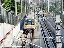
Manila Light Rail Transit System
The Manila Light Rail Transit system, run by the LRTA, is one of the main railway networks of Metro Manila.[21] It has a total of 31 stations (20 in Line 1 and 11 for Line 2), over a total of 31 kilometers of grade separated track. Line 1 runs along parts of Taft Avenue, Rizal Avenue, and Epifanio de los Santos Avenue (EDSA), traveling a north–south route through the cities of Quezon City, Caloocan, Manila, Pasay and Paranaque. On the other hand, Line 2 covers parts of Recto Avenue, Legarda Street, Magsaysay Boulevard, Aurora Boulevard, and Marikina-Infanta Highway (Marcos Highway), in an east–west route which passes through the cities of Manila, Marikina, San Juan, Quezon City, and Antipolo in Rizal. Although Line 2 has been part of the system, it is actually a heavy rail full-metro rapid transit line. Combined, the two lines have a daily ridership of 750,000.
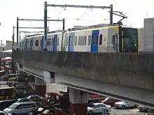
Manila Metro Rail Transit System
The Manila Metro Rail Transit system is another railway network in Metro Manila, composed of independent railway lines not under the control or supervision of the LRTA or PNR. Currently it is only composed of one line, Line 3, which was completed in 2000.[22] This single line runs solely along Epifanio de los Santos Avenue (EDSA), one of Metro Manila's main thoroughfares. Line 3 has 13 stations along its 16.95 kilometers of grade separated track, on a north–south route which passes through the cities of Quezon City, Mandaluyong, Makati and Pasay. The busiest among the rail lines, it has a daily ridership of almost 600,000. The system is set to gain a new line in 2021 with the opening of Line 7,[23] currently under construction, which will run from the North EDSA common station through Commonwealth Avenue to San Jose del Monte, Bulacan.
PNR Metro Commuter Line
Philippine National Railways (PNR) operates a commuter line that serves a region from Metro Manila south toward Laguna. PNR, a state-owned railway system of the Philippines, was established during the Spanish Colonial period. It used to provide services on Luzon, connecting northern and southern Luzon with Manila. In 1988, the railway line to northern Luzon (Northrail) became disused although plans to revive the northern line (Northrail) have been proposed. Services on the southern line (Southrail) continued throughout the 90s, but were halted as a consequence of damages caused by typhoons Milenyo and Reming. After a short revival, services to Bicol from Manila were halted again in 2012. The national government plans to reopen the line to Bicol in the future.
The Philippine National Railways commuter service line, Metro Commuter Line has two parts. Metro South Commuter run daily between Tutuban and Alabang.[24] There are plans to extend this service further south to Calamba with the rehabilitation of the rail line. Metro North Commuter run between Tutuban and Governor Pascual.
The North and South Commuters combined, when fully rehabilitated, will have a length of 122 kilometers from Clark in Pampanga in the north to Calamba, Laguna in the south, and stop at all 48 train stations in between. The Metro Commuter has a present ridership of 100,000 daily.
Future rail projects
The projected 2024 railway Map of Metro Manila, excluding the Makati Subway[25]
Future commuter rail and rapid transit systems are being planned and constructed in Metro Manila. Projects include:
- Rehabilitation of the current PNR Metro Commuter service to Valenzuela
- North–South Commuter Railway
- Line 1 Southern Extension Project
- Line 4
- Line 5 (Makati Subway)
- Line 6[26]
- Line 7
- Line 8, also known as the PNR East-West Railway.[27]
- Line 9 (Metro Manila Subway)
- Makati-BGC Skytrain[28]
- Line 10[29]
As of January 2021, the government's mass transit infrastructure build-up is active:
- Upgrading and extension of the PNR Metro North Commuter Line Phase 1, extending from Tutuban central terminal to Malolos, Bulacan, under construction.
- PNR Metro North Commuter Line Phase 2, further extending from Malolos to New Clark City with a spur to the Clark International Airport, in pre-construction.
- Line 1 southern extension to Bacoor, Cavite, under construction.
- Line 2 east extension to Antipolo, under construction.
- Line 4, an approved Metro line, in pre-construction.
- Line 5 (Makati Subway), an approved underground Metro line in Makati, under construction.
- Line 7, a new Metro line, under construction.
- Line 8, a proposed Metro line, for approval. Also known as the PNR East-West Railway.[27]
- Line 9 (Metro Manila Subway), a new underground Metro line, under construction.
- Makati-BGC Skytrain, an approved monorail line connecting Line 3 Guadalupe Station to Bonifacio Global City, in pre-construction.[28]
- Line 10, an unsolicited proposal for a metro line along the C-5 Corridor, for endorsement by the Department of Transportation to the NEDA Board.[29]
- Line 11, an unsolicited proposal for a metro line along Quirino Highway and Zabarte Road Corridor, for endorsement by the Department of Transportation to the NEDA Board.[30]
Bus rapid transit (BRT)
The EDSA Busway is the first and only Bus Rapid Transit (BRT) system currently existing in Metro Manila starts from Monumento in Caloocan until Parañaque Integrated Terminal Exchange (PITX).
A planned introduction to the metropolis is the rapid bus transit (BRT), a system that makes use of a dedicated lane, buses with large traffic volume, suitable stations and employs intelligent transportation system. Several BRT lines have been discussed and proposed, all are pending approval.
- Bonifacio Global City Bus[31]
- C-5
- Quezon Avenue to Manila City Hall
Air transportation
Airports

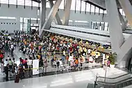
The Ninoy Aquino International Airport (IATA airport code MNL) is the main international gateway to the Philippines, located between Pasay and Parañaque, about seven kilometers south of Manila city proper and southwest of Makati. Terminal 1 only serves international flights. All foreign carriers operating in Manila use Terminal 1 except for All Nippon Airways, Cathay Pacific, Delta Air Lines, Emirates, KLM, Qantas, Qatar Airways, Singapore Airlines and United Airlines. Terminal 2 (or the Centennial Terminal), opened in October 1999, is used exclusively by Philippine Airlines for both its domestic and international service. Terminal 3, opened in August 2008, is the home terminal of Cebu Pacific, the country's second largest airline. Its international wing houses the 9 foreign carriers not using Terminal 1. It also houses some domestic flights of PAL through its subsidiary Air Philippines. Terminal 4 is used by smaller aircraft of all domestic carriers, and by Air Asia as well.
With a record-breaking 42-million people using the airport in 2017, NAIA has long breached the 30-million combined passenger capacity of its four terminals.[33] A proposal to expand NAIA, submitted by a consortium of the country's largest conglomerates, involves the expansion of the current terminals and the construction of an integrated hub as well as a second parallel runway.[33] There are also exploratory talks to transfer terminal assignments among airlines.[34]
Both NAIA and Clark International Airport, located in the Clark Freeport Zone in Angeles, Pampanga serve the Manila area, with CIA catering mostly to low-cost carriers that avail themselves of the lower landing fees than those charged at NAIA. In 2018, Clark handled 2.6 million passengers, all the while undergoing expansion to bring capacity to 12 million with the addition of a second terminal to be finished by 2020.
Proposed airports
In June 2014, JICA formally recommended the construction of a new airport in the vicinity of Sangley Point, Cavite City to replace the space-constricted NAIA. The recommendation involved the reclamation of Manila Bay to locate the new airport. This is contained in JICA's Metro Manila Dream Plan roadmap.
San Miguel Corporation, builders and concessionaires of the Manila Skyway and other infrastructure projects, submitted another unsolicited proposal in April 2018 to build an airport in northeast Manila Bay. In July 2019, the Swiss challenge period ended with no rival bids, and in September 2019 was given the Notice to Proceed from the Department of Transportation to build, operate and maintain the New Manila International Airport.[35] Pre-construction activities, including dredging of the rivers and canals leading to the site, began in October 2020. The first phase, consisting of two runways and the terminal buildings, is scheduled for completion by 2026.[36] The proposed aerotropolis will be located at a reclaimed area of Manila Bay in Bulacan, Bulacan. (This is a current event; developments are ongoing along this issue.)
Water transportation

Seaports and piers
The Port of Manila, located in the vicinity of Manila Bay, is the chief seaport of the Philippines. It primarily serves the city's commercial needs. North Harbor and South Harbor experience busy periods during long holidays such as Holy Week, All Saints Day and the Christmas holidays.
Pasig River Ferry
The Pasig River Ferry Service operates 17 stations along the Pasig River from Plaza Mexico in Intramuros to Pasig. The ferry service is the only water-based transportation that cruised the Pasig River.
See also
- Metro Manila Rapid Transit
- Manila Light Rail Transit System
- Manila Metro Rail Transit System
- Metro Rail Transit Corporation
- Philippine National Railways
- Public transport in Metro Manila
- Traffic in Metro Manila
- PUVMP
- Transportation in the Philippines
- Department of Public Works and Highways
- Department of Transportation
- Philippine highway network
- Strong Republic Nautical Highway
References
- https://www.rappler.com/views/imho/134847-open-letter-duterte-traffic-crisis
- https://gdfi.com.ph/2018/10/25/car-ownership-philippines/
- "Government keen on improving public transport system". Philstar. Retrieved 2013-01-30.
- https://www.jica.go.jp/topics/news/2014/ku57pq00001nkatn-att/20140917_01_0rev20150206.pdf
- http://www.build.gov.ph/
- https://www.youtube.com/watch?v=8uytbWBgEgU
- "DOTr break ground on South East Metro Manila Expressway project". CNN Philippines. January 8, 2018. Retrieved January 18, 2018.
- "'Skybridge' promises 15-minute Makati-QC travel". January 3, 2012. Retrieved March 10, 2012.
- Placido, Dharel (13 July 2017). "Construction of two China-sponsored bridges to begin this year". ABS-CBN News. Retrieved 29 June 2017.
- "Why GrabTaxi?". Grab.
- Lema, Karen (2007-11-20). "Manila's jeepney pioneer fears the end of the road". Reuters. Retrieved 2008-02-27.
- http://www.diva-portal.org/smash/get/diva2:22252/FULLTEXT01.pdf
- Agaton, Casper Boongaling; Guno, Charmaine Samala; Villanueva, Resy Ordona; Villanueva, Riza Ordona (2019). "Diesel or Electric Jeepney? A Case Study of Transport Investment in the Philippines Using the Real Options Approach". World Electric Vehicle Journal. 10 (3): 51. doi:10.3390/wevj10030051.
- Periabras, Rosalie C. (5 August 2015). "DOTC, PUJ operators tackle jeepney modernization". The Manila Times. Retrieved 26 April 2016.
- Badilla, Nielson S. (31 January 2016). "Groups to protest jeepney phaseout". The Manila Times. Retrieved 26 April 2016.
- De Vera, Ellalyn (17 April 2016). "LTFRB urged to shelve planned phaseout of traditional jeepneys". Manila Bulletin. Retrieved 26 April 2016.
- "Can a 'tap card' payment system convince you to take jeepneys again?". Top Gear Philippines. Retrieved 17 April 2018.
- PH, Carmudi. "DOTr launches PUV Modernization Expo". Yahoo News.
- http://pcij.org/stories/too-many-buses-too-many-agencies-clog-edsa/
- https://www.philstar.com/nation/2018/11/06/1866356/mmda-eyes-total-ban-provincial-bus-terminals-along-edsa-january
- http://www.lrta.gov.ph/
- https://web.archive.org/web/20140508151958/http://dotcmrt3.gov.ph/about.php?route=4
- https://ppp.gov.ph/in_the_news/mrt-7-to-be-completed-by-q4-2019-tugade/
- http://www.pnr.gov.ph/northbound-southbound-timetable
- https://m.facebook.com/story.php?story_fbid=10157763150181977&id=116724526976
- https://ppp.gov.ph/ppp_projects/modified-lrt-6-project/
- https://ppp.gov.ph/ppp_projects/east-west-rail-project/
- https://ppp.gov.ph/ppp_projects/fort-bonifacio-makati-skytrain-project/
- https://ppp.gov.ph/ppp_projects/c5-mrt-10-project/
- https://ppp.gov.ph/ppp_projects/mrt-11-project/
- https://ppp.gov.ph/ppp_projects/bonifacio-global-city-brt/
- https://p2pbus.ph/
- https://www.philstar.com/other-sections/starweek-magazine/2018/11/04/1865536/uncertain-future-whats-next-naia
- https://www.bworldonline.com/no-changes-in-naia-terminal-assignments-for-airlines-by-aug-31/
- Lopez, Melissa Luz (18 September 2019). "Bulacan airport deal signed, construction to start December". CNN Philippines. Retrieved 18 September 2019.
- Gonzales, Iris (October 7, 2020). "SMC to start construction of Bulacan airport". The Philippine Star. Retrieved October 8, 2020.
| Topics |  | |
|---|---|---|
| Government |
| |
| Districts | ||
| Mixed-use developments | ||
| Beaches | ||
| Congressional Districts | ||
| ||