Matool
Matool (also Mattul) is about 19 kilometres (12 mi) north of Kannur, in North Kerala, South India. The Valapattanam River and Kuppam River meet the Arabian sea at Matool.You can reach Matool from Kannur via Azheekal crossing the Matool - Azheekal ferry. And via Madakkara-Matool Bridge From Irinavu Road
Matool
Mattool | |
|---|---|
village | |
 Mattool Beach | |
| Coordinates: 11.957955°N 75.294159°E | |
| Country | |
| State | Kerala |
| District | Kannur (Hindi: कण्णूर ) |
| Population (2011) | |
| • Total | 26,086 |
| Languages | |
| • Official | Malayalam, |
| Time zone | UTC+5:30 (IST) |
| Telephone code | 0497284**** |
| ISO 3166 code | IN-KL |
| Vehicle registration | KL-13 |
| Website | http://mattoolonline.com |
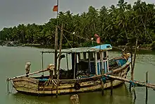
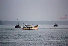
Matool is considered a boating destination with boat services to various coastal areas of Kannur district.
Demographics
As of 2011 India census, Mattool had a population of 26,086 with 12,094 males and 13,992 females.[1]
Transportation
The national highway passes through Taliparamba town. Goa and Mumbai can be accessed on the northern side and Cochin and Thiruvananthapuram can be accessed on the southern side. The road to the east of Iritty connects to Mysore and Bangalore. The nearest railway station is Pazhayangadi on Mangalore-Palakkad line. Trains are available to almost all parts of India subject to advance booking over the internet. There are airports at Kannur, Mangalore and Calicut. All of them are international airports but direct flights are available only to Middle Eastern countries.
See also
- Ezhimala Hill
- Kannur
- Madayi
- Pazhayangadi
- Madayipara
References
- "Census of India : Villages with population 5000 & above". Registrar General & Census Commissioner, India. Archived from the original on 8 December 2008. Retrieved 10 December 2008.
| Wikimedia Commons has media related to Matool. |