Pendleton County, West Virginia
Pendleton County is a county located in the U.S. state of West Virginia. As of the 2010 census, the population was 7,695,[1] making it the fifth-least populous county in West Virginia. Its county seat is Franklin.[2] The county was created by the Virginia General Assembly in 1788[3] from parts of Augusta, Hardy, and Rockingham Counties and was named for Edmund Pendleton (1721–1803), a distinguished Virginia statesman and jurist.[4][5] Pendleton County was strongly pro-Confederate during the American Civil War; however, there were pockets of Unionists who supported the state government in Wheeling.[6]
Pendleton County | |
|---|---|
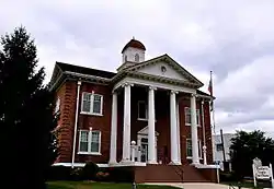 Pendleton County Courthouse | |
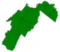
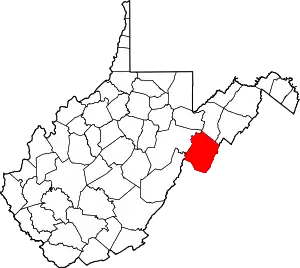 Location within the U.S. state of West Virginia | |
 West Virginia's location within the U.S. | |
| Coordinates: 38°41′N 79°22′W | |
| Country | |
| State | |
| Founded | May 1, 1788 |
| Named for | Edmund Pendleton |
| Seat | Franklin |
| Largest town | Franklin |
| Area | |
| • Total | 698 sq mi (1,810 km2) |
| • Land | 696 sq mi (1,800 km2) |
| • Water | 2.1 sq mi (5 km2) 0.3%% |
| Population (2010) | |
| • Total | 7,695 |
| • Estimate (2019) | 6,969 |
| • Density | 11/sq mi (4.3/km2) |
| Time zone | UTC−5 (Eastern) |
| • Summer (DST) | UTC−4 (EDT) |
| Congressional district | 2nd |
| Website | www |
Spruce Knob, located in Pendleton County, is the highest point in the state and in the Alleghenies, its elevation being 4,863 feet. Parts of the Monongahela and George Washington National Forests are also located in Pendleton.
History
By the 1740s, the three main valleys of what became Pendleton County had been visited and named by white hunters and prospectors. One of the hunters, a single man named Abraham Burner, built himself a log cabin about a half mile downstream of the future site of Brandywine in 1745. He was the county's first white settler. A local historian recorded that:
The site ... [was] on the left bank of the river, and near the beginning of a long, eastward bend. From almost at his very door his huntsman's eye was at times gladdened by seeing perhaps fifty deer either drinking from the steam or plunging in their heads up to their ears in search of moss.[7]
By 1747, immigrants were impinging on the (future) borders of Pendleton from two directions: the larger community was mostly Germans moving up the valley of the South Branch Potomac; the lesser consisted mainly of Scotch-Irish moving northwest from Staunton up into the headwaters of the James River. In an April 1758 surprise raid of Fort Seybert and nearby Fort Upper Tract occasioned by the French and Indian War (1754–63), most of the 60 white settlers sheltering there were massacred by Shawnee and Delaware warriors and the forts were burned.
Pendleton County was created by the Virginia General Assembly in 1788 from parts of Augusta, Hardy, and Rockingham Counties and was named for Edmund Pendleton, a distinguished Virginia statesman and jurist. Pendleton County was split between Northern and Southern sympathies during the American Civil War. The northern section of the county, including the enclave in the Smoke Hole community were staunchly Unionist. In June 1863, the county was included by the federal government in the new state of West Virginia against the wishes of many of the inhabitants. That fall, Union General W.W. Averell swept up the South Branch valley, and destroyed the Confederate saltpetre works above Franklin.[8]
In the months following the state's establishment, West Virginia's counties were divided into civil townships, with the intention of encouraging local government. This proved impractical in the heavily rural state, and in 1872 the townships were converted into magisterial districts.[9] Pendleton County was divided into six districts: Bethel, Circleville, Franklin, Mill Run, Sugar Grove, and Union. Except for minor adjustments, these magisterial districts remained largely unchanged until the 1990s, when they were consolidated into three new districts: Central, Eastern, and Western.[10]
Pendleton County and the surrounding area were hit by severe flooding in November 1985. At Franklin, the county seat, the South Branch of the Potomac crested at 22.6 feet, more than fifteen feet[lower-roman 1] above flood stage in the shallow riverbed.[11] Sixty-two people were killed in West Virginia, Virginia, Maryland, and Pennsylvania, in what became known as the "1985 Election Day floods" in Virginia, or the "Killer Floods of 1985" in West Virginia. According to the National Weather Service, thirty-eight of the deaths occurred in Pendleton and Grant Counties, West Virginia.[11] Twenty-two people were killed in Virginia, and there was one fatality each attributed to the flooding in Maryland and Pennsylvania.
Geography

According to the U.S. Census Bureau, the county has a total area of 698 square miles (1,810 km2), of which 696 square miles (1,800 km2) is land and 2.1 square miles (5.4 km2) (0.3%) is water.[12] It is the fifth-largest county in West Virginia by area.
Adjacent counties
- Grant County (north)
- Hardy County (northeast)
- Rockingham County, Virginia (east)
- Augusta County, Virginia (south)
- Highland County, Virginia (south)
- Pocahontas County (southwest)
- Randolph County (west)
National protected areas
National Natural Landmarks
- Germany Valley Karst Area
- Sinnett-Thorn Mountain Cave System
Economy
Pendleton County's economy consists mainly of small to medium-sized farms and small businesses. Most of these are in Franklin, the county's only incorporated town. The North Fork Valley, on the western side of the county, has a number of businesses that cater to tourists who come for the area's outdoor recreation opportunities. These include motels, restaurants, and guide services. In recent years, maple syrup has emerged as a major growth industry in the county. Dry Fork Maple Works, the state's largest maple sugaring operation, is based in Pendleton County (though its sugaring operation occurs mainly in neighboring Randolph County).[13]
The county is also home to a number of non-profits whose reaches extend well beyond the county lines. These include Almost Heaven Habitat for Humanity, Future Generations and Future Generations Graduate School, The Mountain Institute, and Mountain Springs Farm and Heritage Center.
Sugar Grove Station, an electronic listening post for the National Security Agency, is located near the southeast corner of the Pendleton County.[14]
Demographics
| Historical population | |||
|---|---|---|---|
| Census | Pop. | %± | |
| 1790 | 2,452 | — | |
| 1800 | 3,962 | 61.6% | |
| 1810 | 4,239 | 7.0% | |
| 1820 | 4,846 | 14.3% | |
| 1830 | 6,271 | 29.4% | |
| 1840 | 6,940 | 10.7% | |
| 1850 | 5,795 | −16.5% | |
| 1860 | 6,164 | 6.4% | |
| 1870 | 6,455 | 4.7% | |
| 1880 | 8,022 | 24.3% | |
| 1890 | 8,711 | 8.6% | |
| 1900 | 9,167 | 5.2% | |
| 1910 | 9,349 | 2.0% | |
| 1920 | 9,652 | 3.2% | |
| 1930 | 9,660 | 0.1% | |
| 1940 | 10,884 | 12.7% | |
| 1950 | 9,313 | −14.4% | |
| 1960 | 8,093 | −13.1% | |
| 1970 | 7,031 | −13.1% | |
| 1980 | 7,910 | 12.5% | |
| 1990 | 8,054 | 1.8% | |
| 2000 | 8,196 | 1.8% | |
| 2010 | 7,695 | −6.1% | |
| 2019 (est.) | 6,969 | [15] | −9.4% |
| U.S. Decennial Census[16] 1790–1960[17] 1900–1990[18] 1990–2000[19] 2010–2019[1] | |||
2000 census
As of the census[20] of 2000, there were 8,196 people, 3,350 households, and 2,355 families residing in the county. The population density was 12 people per square mile (5/km2). There were 5,102 housing units at an average density of 7 per square mile (3/km2). The racial makeup of the county was 96.34% White, 2.12% Black or African American, 0.27% Native American, 0.18% Asian, 0.04% Pacific Islander, 0.28% from other races, and 0.77% from two or more races. 0.89% of the population were Hispanic or Latino of any race.
There were 3,350 households, out of which 28.00% had children under the age of 18 living with them, 57.40% were married couples living together, 8.10% had a female householder with no husband present, and 29.70% were non-families. 25.80% of all households were made up of individuals, and 12.20% had someone living alone who was 65 years of age or older. The average household size was 2.40 and the average family size was 2.87.
In the county, the population was spread out, with 21.80% under the age of 18, 7.30% from 18 to 24, 27.00% from 25 to 44, 26.10% from 45 to 64, and 17.80% who were 65 years of age or older. The median age was 41 years. For every 100 females there were 101.30 males. For every 100 females age 18 and over, there were 101.50 males.
The median income for a household in the county was $30,429, and the median income for a family was $34,860. Males had a median income of $25,342 versus $16,753 for females. The per capita income for the county was $15,805. About 8.00% of families and 11.40% of the population were below the poverty line, including 13.60% of those under age 18 and 12.50% of those age 65 or over.
2010 census
As of the 2010 United States Census, there were 7,695 people, 3,285 households, and 2,179 families residing in the county.[21] The population density was 11.1 inhabitants per square mile (4.3/km2). There were 5,132 housing units at an average density of 7.4 per square mile (2.9/km2).[22] The racial makeup of the county was 96.2% white, 1.9% black or African American, 0.3% Asian, 0.2% American Indian, 0.2% from other races, and 1.2% from two or more races. Those of Hispanic or Latino origin made up 0.9% of the population.[21] In terms of ancestry, 30.1% were German, 8.1% were American, 7.3% were Irish, and 6.4% were English.[23]
Of the 3,285 households, 24.8% had children under the age of 18 living with them, 54.6% were married couples living together, 7.1% had a female householder with no husband present, 33.7% were non-families, and 29.0% of all households were made up of individuals. The average household size was 2.28 and the average family size was 2.80. The median age was 47.3 years.[21]
The median income for a household in the county was $33,323 and the median income for a family was $49,613. Males had a median income of $38,190 versus $23,243 for females. The per capita income for the county was $19,401. About 11.0% of families and 15.1% of the population were below the poverty line, including 17.3% of those under age 18 and 22.2% of those age 65 or over.[24]
Politics
| Year | Republican | Democratic | Third parties |
|---|---|---|---|
| 2016 | 73.7% 2,398 | 22.4% 729 | 3.9% 127 |
| 2012 | 64.3% 2,095 | 33.0% 1,074 | 2.7% 87 |
| 2008 | 59.9% 2,035 | 38.6% 1,310 | 1.5% 50 |
| 2004 | 60.6% 2,146 | 39.0% 1,381 | 0.5% 17 |
| 2000 | 62.0% 1,996 | 36.4% 1,172 | 1.7% 53 |
| 1996 | 43.3% 1,431 | 48.1% 1,591 | 8.6% 286 |
| 1992 | 44.4% 1,589 | 45.4% 1,626 | 10.3% 368 |
| 1988 | 54.3% 1,901 | 45.5% 1,595 | 0.2% 7 |
| 1984 | 58.2% 2,047 | 41.6% 1,464 | 0.2% 7 |
| 1980 | 47.9% 1,677 | 49.2% 1,724 | 2.9% 103 |
| 1976 | 42.5% 1,554 | 57.5% 2,104 | |
| 1972 | 63.9% 2,207 | 36.1% 1,248 | |
| 1968 | 46.5% 1,687 | 45.3% 1,643 | 8.2% 298 |
| 1964 | 34.2% 1,296 | 65.8% 2,498 | |
| 1960 | 48.4% 1,930 | 51.6% 2,057 | |
| 1956 | 49.5% 1,959 | 50.5% 1,999 | |
| 1952 | 48.3% 1,859 | 51.7% 1,991 | |
| 1948 | 44.9% 1,592 | 54.9% 1,944 | 0.2% 7 |
| 1944 | 45.8% 1,838 | 54.2% 2,177 | |
| 1940 | 42.2% 1,977 | 57.8% 2,710 | |
| 1936 | 40.5% 1,800 | 59.3% 2,637 | 0.3% 13 |
| 1932 | 37.1% 1,502 | 62.5% 2,530 | 0.4% 15 |
| 1928 | 47.1% 1,710 | 52.9% 1,921 | |
| 1924 | 41.7% 1,462 | 58.1% 2,037 | 0.3% 9 |
| 1920 | 46.5% 1,581 | 53.4% 1,814 | 0.1% 4 |
| 1916 | 40.9% 888 | 58.7% 1,276 | 0.4% 9 |
| 1912 | 22.8% 475 | 55.7% 1,162 | 21.6% 451 |
Communities
Towns
- Franklin (county seat)
Current
- Central
- Eastern
- Western
Historic
- Bethel
- Circleville
- Franklin
- Mill Run
- Sugar Grove
- Union
Census-designated place
Unincorporated communities
- Big Run
- Brushy Run
- Cave
- Cherry Grove
- Circleville
- Dahmer
- Deer Run
- Dry Run
- Entry
- Fame
- Fort Seybert
- Harper
- Judy Gap
- Ketterman
- Kline
- Macksville
- Miles
- Mitchell
- Moatstown
- Monkeytown
- Moyers
- Mozer
- Oak Flat
- Oak Grove
- Onego
- Propstburg
- Riverton
- Ruddle
- Seneca Rocks
- Simoda
- Sugar Grove
- Teterton
- Upper Tract
- Zigler
Historic Places
The following sites are listed on the National Register of Historic Places.
| Site | Year Built | Address | Community | Listed |
|---|---|---|---|---|
| Bowers House | late 19th century | Brandywine-Sugar Grove Road | Sugar Grove | 1985 |
| Circleville School | 1930s | WV 28 | Circleville | 1995 |
| Cunningham-Hevener House | late 19th century | US 220 | Upper Tract | 1985 |
| Franklin Historic District | 19th-20th centuries | US 33, Main Street, South Branch Potomac River, & High Street | Franklin | 1986 |
| McCoy House | 1848 | Main Street | Franklin | 1982 |
| McCoy Mill | early 19th century | Johnstown Road | Franklin | 1986 |
| Old Judy Church (Old Log Church) | early 19th century | US 220 | near Petersburg | 1976 |
| Old Propst Church | late 18th century | CR 21/9 | Brandywine | 1986 |
| Pendleton County Poor Farm | early 20th century | US 220 | Upper Tract | 1986 |
| Priest Mill | early 20th century | Off US 220, near Low-Water Bridge | Franklin | 2000 |
| Sites Homestead (Wayside Inn) | early 19th century | Seneca Rocks Visitor Center | Seneca Rocks | 1993 |
Gallery
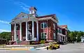 Pendleton County Courthouse
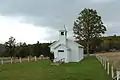 Solomon's Chapel, one of the many smaller churches in Pendleton County, WV
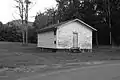 Mount Joel Schoolhouse, Simoda WV
See also
Footnotes
- At Franklin, flood stage begins at only seven feet.
References
- "State & County QuickFacts". United States Census Bureau. Archived from the original on June 7, 2011. Retrieved January 11, 2014.
- "Find a County". National Association of Counties. Retrieved June 7, 2011.
- "Archived copy". Archived from the original on June 13, 2010. Retrieved January 29, 2013.CS1 maint: archived copy as title (link)
- "Pendleton County". West Virginia Division of Culture and History. Archived from the original on January 1, 2014. Retrieved August 11, 2015.
- "West Virginia: Individual County Chronologies". West Virginia Atlas of Historical County Boundaries. The Newberry Library. 2003. Retrieved August 11, 2015.
- Pendleton County History, Dr. Robert Jay Dilger, Director, Institute for Public Affairs and Professor of Political Science, West Virginia University. "Archived copy". Archived from the original on June 13, 2010. Retrieved January 29, 2013.CS1 maint: archived copy as title (link)
- Morton, Oren F. (1910), A History of Pendleton County, West Virginia, Franklin, West Virginia. Reprint (1974) by Regional Publishing Company, Baltimore, pp 31-32.
- West Virginia Writers Project (1940), Smoke Hole and Its People: A Social-Ethnic Study; Charleston, West Virginia: State Department of Education; Reprinted (pp 101-132) in: Shreve, D. Bardon (2005), Sheriff from Smoke Hole (and Other Smoke Hole Stories), Fredericksburg, Virginia: The Fredericksburg Press, Inc, pg 118.
- Otis K. Rice & Stephen W. Brown, West Virginia: A History, 2nd ed., University Press of Kentucky, Lexington (1993), p. 240.
- United States Census Bureau, U.S. Decennial Census, Tables of Minor Civil Divisions in West Virginia, 1870–2010.
- West Virginia Gazette: "Remembering the '85 floods" (D. White) 4 Nov 2010
- "2010 Census Gazetteer Files". United States Census Bureau. August 22, 2012. Retrieved July 30, 2015.
- "Maple syrup pouring out of West Virginia". West Virginia Press. December 8, 2014. Retrieved March 28, 2018.
- e-WV: The West Virginia Encyclopedia. (2015). "Sugar Grove Naval Station." e-WV: The West Virginia Encyclopedia. Accessed January 28, 2016.
- "Population and Housing Unit Estimates". Retrieved March 29, 2020.
- "U.S. Decennial Census". United States Census Bureau. Retrieved January 11, 2014.
- "Historical Census Browser". University of Virginia Library. Retrieved January 11, 2014.
- "Population of Counties by Decennial Census: 1900 to 1990". United States Census Bureau. Retrieved January 11, 2014.
- "Census 2000 PHC-T-4. Ranking Tables for Counties: 1990 and 2000" (PDF). United States Census Bureau. Retrieved January 11, 2014.
- "U.S. Census website". United States Census Bureau. Retrieved May 14, 2011.
- "DP-1 Profile of General Population and Housing Characteristics: 2010 Demographic Profile Data". United States Census Bureau. Archived from the original on February 13, 2020. Retrieved April 3, 2016.
- "Population, Housing Units, Area, and Density: 2010 - County". United States Census Bureau. Archived from the original on February 13, 2020. Retrieved April 3, 2016.
- "DP02 SELECTED SOCIAL CHARACTERISTICS IN THE UNITED STATES – 2006-2010 American Community Survey 5-Year Estimates". United States Census Bureau. Archived from the original on February 13, 2020. Retrieved April 3, 2016.
- "DP03 SELECTED ECONOMIC CHARACTERISTICS – 2006-2010 American Community Survey 5-Year Estimates". United States Census Bureau. Archived from the original on February 13, 2020. Retrieved April 3, 2016.
- Leip, David. "Dave Leip's Atlas of U.S. Presidential Elections". uselectionatlas.org. Retrieved March 28, 2018.
External links
| Wikimedia Commons has media related to Pendleton County, West Virginia. |
- Guide to Pendleton County
- Pendleton County Chamber of Commerce
- Pendleton County Economic & Community Development Authority
- Pendleton County Schools
- Visit Pendleton County
Places adjacent to Pendleton County, West Virginia | ||||||||||
|---|---|---|---|---|---|---|---|---|---|---|
| ||||||||||
Municipalities and communities of Pendleton County, West Virginia, United States | ||
|---|---|---|
| Town | Map of West Virginia highlighting Pendleton County | |
| CDP | ||
| Unincorporated communities | ||
| Ghost towns | ||
| ||
| Authority control |
|---|