National Register of Historic Places listings in Pendleton County, West Virginia
This is a list of the National Register of Historic Places listings in Pendleton County, West Virginia.
This is intended to be a complete list of the properties and districts on the National Register of Historic Places in Pendleton County, West Virginia, United States. The locations of National Register properties and districts for which the latitude and longitude coordinates are included below, may be seen in a Google map.[1]
There are 13 properties and districts listed on the National Register in the county.
- This National Park Service list is complete through NPS recent listings posted January 29, 2021.[2]
Barbour - Berkeley - Boone - Braxton - Brooke - Cabell - Calhoun - Clay - Doddridge - Fayette - Gilmer - Grant - Greenbrier - Hampshire - Hancock - Hardy - Harrison - Jackson - Jefferson - Kanawha - Lewis - Lincoln - Logan - Marion - Marshall - Mason - McDowell - Mercer - Mineral - Mingo - Monongalia - Monroe - Morgan - Nicholas - Ohio - Pendleton - Pleasants - Pocahontas - Preston - Putnam - Raleigh - Randolph - Ritchie - Roane - Summers - Taylor - Tucker - Tyler - Upshur - Wayne - Webster - Wetzel - Wirt - Wood - Wyoming |
Current listings
| [3] | Name on the Register[4] | Image | Date listed[5] | Location | City or town | Description |
|---|---|---|---|---|---|---|
| 1 | Boggs Mill | August 25, 2004 (#04000915) |
U.S. Route 33 and WV 28, north of junction with County Route 9 38°49′09″N 79°23′09″W |
Seneca Rocks | ||
| 2 | Bowers House | 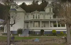 Bowers House |
July 10, 1985 (#85001593) |
Brandywine-Sugar Grove Rd. 38°30′43″N 79°18′37″W |
Sugar Grove | |
| 3 | Circleville School | 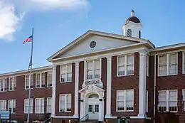 Circleville School |
November 9, 1995 (#95001323) |
WV 28 38°40′21″N 79°29′31″W |
Circleville | |
| 4 | Cunningham-Hevener House | July 10, 1985 (#85001595) |
U.S. Route 220 38°46′40″N 79°17′05″W |
Upper Tract | ||
| 5 | Franklin Historic District | 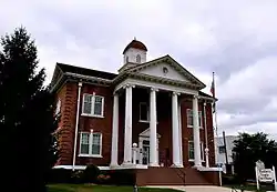 Franklin Historic District |
January 15, 1986 (#86000773) |
Roughly bounded by U.S. Route 33, Main St., the Potomac River, and High St. 38°38′37″N 79°19′57″W |
Franklin | |
| 6 | McCoy House | 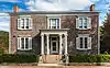 McCoy House |
December 10, 1982 (#82004328) |
Main St. 38°38′29″N 79°19′52″W |
Franklin | |
| 7 | McCoy Mill |  McCoy Mill |
January 14, 1986 (#86000780) |
Johnstown Rd. 38°36′34″N 79°21′04″W |
Franklin | |
| 8 | Old Judy Church | 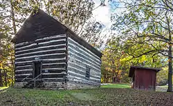 Old Judy Church |
May 13, 1976 (#76001944) |
10 miles south of Petersburg on U.S. Route 220 38°52′00″N 79°13′07″W |
Petersburg | |
| 9 | Old Probst Church |  Old Probst Church |
January 14, 1986 (#86000779) |
County Route 21/9 38°35′53″N 79°15′25″W |
Brandywine | |
| 10 | Pendleton County Poor Farm | 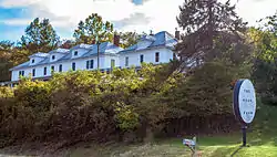 Pendleton County Poor Farm |
January 14, 1986 (#86000775) |
U.S. Route 220 38°44′59″N 79°17′15″W |
Upper Tract | |
| 11 | Ananias Pitsenbarger Farm |  Ananias Pitsenbarger Farm |
August 18, 2011 (#11000557) |
WV 23 approximately 1/4 mile south of junction with County Route 23/1 38°34′40″N 79°19′07″W |
Franklin | |
| 12 | Priest Mill |  Priest Mill |
April 4, 2000 (#00000250) |
Off U.S. Route 220, near the Low-Water Bridge 38°38′22″N 79°19′50″W |
Franklin | |
| 13 | Sites Homestead |  Sites Homestead |
May 20, 1993 (#93000382) |
Seneca Rocks Visitor Center 38°50′09″N 79°22′26″W |
Seneca Rocks |
See also
| Wikimedia Commons has media related to National Register of Historic Places in Pendleton County, West Virginia. |
References
- The latitude and longitude information provided in this table was derived originally from the National Register Information System, which has been found to be fairly accurate for about 99% of listings. Some locations in this table may have been corrected to current GPS standards.
- "National Register of Historic Places: Weekly List Actions". National Park Service, United States Department of the Interior. Retrieved on January 29, 2021.
- Numbers represent an alphabetical ordering by significant words. Various colorings, defined here, differentiate National Historic Landmarks and historic districts from other NRHP buildings, structures, sites or objects.
- "National Register Information System". National Register of Historic Places. National Park Service. April 24, 2008.
- The eight-digit number below each date is the number assigned to each location in the National Register Information System database, which can be viewed by clicking the number.
| Topics | ||
|---|---|---|
| Lists by county |
| |
| Other lists | ||
| ||
Municipalities and communities of Pendleton County, West Virginia, United States | ||
|---|---|---|
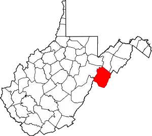
| Town | Map of West Virginia highlighting Pendleton County | |
| CDP | ||
| Unincorporated communities | ||
| Ghost towns | ||
| ||