Riverton, Wyoming
Riverton (Arapaho: Hooxono'o) is a city in Fremont County, Wyoming, United States. The city's population was 10,615 at the 2010 census, making it the largest city in the county overall.
Riverton, Wyoming | |
|---|---|
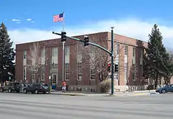 Post office, corner of South 5th St. & Main | |
| Motto(s): "The Rendezvous City" | |
 Location of Riverton in Fremont County, Wyoming. | |
 Riverton, Wyoming Location in the United States | |
| Coordinates: 43°1′30″N 108°22′48″W[1] | |
| Country | United States |
| State | Wyoming |
| County | Fremont |
| Area | |
| • Total | 10.34 sq mi (26.78 km2) |
| • Land | 10.34 sq mi (26.77 km2) |
| • Water | 0.01 sq mi (0.01 km2) |
| Elevation | 4,951 ft (1,509 m) |
| Population | |
| • Total | 10,615 |
| • Estimate (2019)[4] | 10,772 |
| • Density | 1,042.28/sq mi (402.42/km2) |
| Time zone | UTC−7 (Mountain (MST)) |
| • Summer (DST) | UTC−6 (MDT) |
| ZIP code | 82501 |
| Area code(s) | 307 |
| FIPS code | 56-66220[5] |
| GNIS feature ID | 1593489[1] |
| Website | rivertonwy.gov |
History
The city is an incorporated entity of the state of Wyoming. The community was named Riverton because of the four rivers that meet there.[6] The town was built on land ceded from the Wind River Indian Reservation in 1906, a situation that often makes it subject to jurisdictional claims by the nearby Eastern Shoshone and Northern Arapaho tribes.
A legal ruling on November 7, 2017, by the 10th Circuit Court, ruled again in the EPA reservation boundary dispute. Though the decision was complex, the 10th Circuit Court answered plainly. Riverton is not on the reservation. The 10th Circuit's decision is now official and final after the 10th Circuit Court of Appeals 2017 ruling. The Tenth Circuit Court of Appeals reversed the decision of the EPA, and held that the land had been ceded in 1905 by an Act of Congress. This ruling ends the dispute, bringing the debate and controversy to an end.[7]
On August 21, 2017 a Total Solar Eclipse went over Riverton.
Riverton is home to a National Weather Service Forecast Office that is responsible to cover all of western and central Wyoming. There is a WSR-88D (Weather Surveillance Radar 1988 Doppler) Radar at this NWS office.
The Chicago & Northwestern Railway completed an extension of the "Cowboy Line" through to Lander which is about 22 miles west of Riverton. Plans were to continue the line west from Lander. In 1972, the end of the line was moved from Lander and the new terminus of the line was in Riverton. Service was then discontinued in Riverton in the mid-1970's as the line was slowly dismantled west of Casper.
Demographics
| Historical population | |||
|---|---|---|---|
| Census | Pop. | %± | |
| 1910 | 483 | — | |
| 1920 | 2,023 | 318.8% | |
| 1930 | 1,608 | −20.5% | |
| 1940 | 2,540 | 58.0% | |
| 1950 | 4,142 | 63.1% | |
| 1960 | 6,845 | 65.3% | |
| 1970 | 7,995 | 16.8% | |
| 1980 | 9,562 | 19.6% | |
| 1990 | 9,202 | −3.8% | |
| 2000 | 9,310 | 1.2% | |
| 2010 | 10,615 | 14.0% | |
| 2019 (est.) | 10,772 | [4] | 1.5% |
| [8] | |||
2010 census
As of the census[3] of 2010, there were 10,615 people, 4,252 households, and 2,600 families living in the city. The population density was 1,076.6 inhabitants per square mile (415.7/km2). There were 4,567 housing units at an average density of 463.2 per square mile (178.8/km2). The racial makeup of the city was 83.5% White, 0.5% African American, 10.4% Native American, 0.3% Asian, 0.1% Pacific Islander, 1.8% from other races, and 3.5% from two or more races. Hispanic or Latino of any race were 9.0% of the population.
There were 4,252 households, of which 31.0% had children under the age of 18 living with them, 43.2% were married couples living together, 12.9% had a female householder with no husband present, 5.1% had a male householder with no wife present, and 38.9% were non-families. 31.3% of all households were made up of individuals, and 13.6% had someone living alone who was 65 years of age or older. The average household size was 2.37 and the average family size was 2.96.
The median age in the city was 35.4 years. 23.9% of residents were under the age of 18; 11.5% were between the ages of 18 and 24; 25% were from 25 to 44; 24.3% were from 45 to 64; and 15.2% were 65 years of age or older. The gender makeup of the city was 50.0% male and 50.0% female.
2000 census
As of the census[5] of 2000, there were 9,311 people, 3,816 households, and 2,407 families living in the city. The population density was 952.2 people per square mile (367.5/km2). There were 4,254 housing units at an average density of 435.1/sq mi (167.9/km2). The racial makeup of the city was 86.81% White, 0.17% African American, 8.08% Native American, 0.47% Asian, 0.03% Pacific Islander, 1.86% from other races, and 2.58% from two or more races. Hispanic or Latino of any race were 7.09% of the population.
There were 3,816 households, out of which 29.7% had children under the age of 18 living with them, 48.2% were married couples living together, 10.4% had a female householder with no husband present, and 36.9% were non-families. 31.6% of all households were made up of individuals, and 14.3% had someone living alone who was 65 years of age or older. The average household size was 2.33 and the average family size was 2.93.
In the city, the population was spread out, with 24.2% under the age of 18, 10.4% from 18 to 24, 26.0% from 25 to 44, 23.0% from 45 to 64, and 16.4% who were 65 years of age or older. The median age was 38 years. For every 100 females, there were 94.0 males. For every 100 females age 18 and over, there were 92.6 males.
The median income for a household in the city was $31,531, and the median income for a family was $37,079. Males had a median income of $31,685 versus $19,157 for females. The per capita income for the city was $16,720. About 11.0% of families and 15.7% of the population were below the poverty line, including 21.3% of those under age 18 and 11.5% of those age 65 or over.
Geography
Riverton is located just north of the Wind River. U.S. Route 26 and Wyoming Highway 789 pass through the city.[9]
According to the United States Census Bureau, the city has a total area of 9.87 square miles (25.56 km2), of which 9.86 square miles (25.54 km2) is land and 0.01 square miles (0.03 km2) is water.[10]
Climate
Riverton experiences a semi-arid climate (Köppen BSk) with cold, dry winters and warm, slightly wetter summers.
| Climate data for Riverton, Wyoming | |||||||||||||
|---|---|---|---|---|---|---|---|---|---|---|---|---|---|
| Month | Jan | Feb | Mar | Apr | May | Jun | Jul | Aug | Sep | Oct | Nov | Dec | Year |
| Record high °F (°C) | 63 (17) |
71 (22) |
78 (26) |
87 (31) |
96 (36) |
102 (39) |
103 (39) |
104 (40) |
98 (37) |
90 (32) |
73 (23) |
65 (18) |
104 (40) |
| Average high °F (°C) | 30.0 (−1.1) |
37.6 (3.1) |
50.2 (10.1) |
59.8 (15.4) |
69.5 (20.8) |
81.1 (27.3) |
89.0 (31.7) |
87.5 (30.8) |
75.8 (24.3) |
62.0 (16.7) |
43.0 (6.1) |
30.7 (−0.7) |
59.7 (15.4) |
| Daily mean °F (°C) | 14.9 (−9.5) |
22.1 (−5.5) |
34.9 (1.6) |
44.1 (6.7) |
53.8 (12.1) |
63.7 (17.6) |
70.3 (21.3) |
68.2 (20.1) |
57.3 (14.1) |
44.8 (7.1) |
28.2 (−2.1) |
15.9 (−8.9) |
43.2 (6.2) |
| Average low °F (°C) | −0.3 (−17.9) |
6.5 (−14.2) |
19.5 (−6.9) |
28.4 (−2.0) |
38.1 (3.4) |
46.2 (7.9) |
51.5 (10.8) |
48.8 (9.3) |
38.7 (3.7) |
27.6 (−2.4) |
13.3 (−10.4) |
1.1 (−17.2) |
26.6 (−3.0) |
| Record low °F (°C) | −46 (−43) |
−45 (−43) |
−24 (−31) |
−18 (−28) |
18 (−8) |
26 (−3) |
30 (−1) |
30 (−1) |
9 (−13) |
−7 (−22) |
−28 (−33) |
−46 (−43) |
−46 (−43) |
| Average precipitation inches (mm) | 0.28 (7.1) |
0.25 (6.4) |
0.48 (12) |
1.01 (26) |
1.78 (45) |
1.14 (29) |
0.73 (19) |
0.49 (12) |
0.88 (22) |
0.81 (21) |
0.47 (12) |
0.46 (12) |
8.78 (223.5) |
| Source 1: NOAA (normals, 1971–2000)[11] | |||||||||||||
| Source 2: The Weather Channel (Records)[12] | |||||||||||||
Economy
Brunton, Inc. is home to the manufacturer of the Brunton compass.
Airline service
Daily passenger service is available to Denver and Sheridan through FLYRiverton, with service provided by Denver Air Connection. An interline agreement with United allows for bookings to over 400 additional airports in the US. Denver Air Connections maintains flight reliability over 96%.
Riverton Regional Airport also provides rental car services through Hertz as well as general aviation services. The call letters are RIW.
Education
Public education in the city of Riverton is provided by Fremont County School District #25. The district operates three K–3 elementary schools (Ashgrove, Aspen Park, and Jackson), Rendezvous Elementary School (grades 4–5), Riverton Middle School (grades 6–8), and Riverton High School (grades 9–12).
Central Wyoming College is located in Riverton, with off-campus sites in Wyoming in Jackson, Lander, Thermopolis, Dubois, and the Wind River Indian Reservation.
Riverton has a public library, a branch of the Fremont County Library System.[13]
Notable people
- John Bennett Herrington, astronaut
- Lance Deal, four-time Olympic hammer thrower (1988, 1992, 1996, 2000)
- Bucky Jacobsen, former Major League Baseball first baseman for the Seattle Mariners
- Brett Newlin, Olympic rower
- Kristen Newlin, international basketball player
- Ashlynn Yennie, actress
- Darrell Winfield, "Marlboro Man" [14]
References
- U.S. Geological Survey Geographic Names Information System: Riverton, Wyoming
- "2019 U.S. Gazetteer Files". United States Census Bureau. Retrieved August 7, 2020.
- "U.S. Census website". United States Census Bureau. Retrieved December 14, 2012.
- "Population and Housing Unit Estimates". United States Census Bureau. May 24, 2020. Retrieved May 27, 2020.
- "U.S. Census website". United States Census Bureau. Retrieved January 31, 2008.
- "Profile for Riverton, Wyoming, WY". ePodunk. Retrieved July 27, 2012.
- "STATE OF WYOMING, Petitioner, v. UNITED STATES ENVIRONMENTAL PROTECTION AGENCY; E. SCOTT PRUITT" (PDF). Ca10.uscourts.gov. Retrieved January 9, 2018.
- "Historical Decennial Census Population for Wyoming Counties, Cities, and Towns". Wyoming Department of State / U.S. Census Bureau. Retrieved June 30, 2008.
- Riverton West, WY, 7.5 Minute Topographic Quadrangle, USGS, 1951
- "US Gazetteer files 2010". United States Census Bureau. Archived from the original on January 24, 2012. Retrieved December 14, 2012.
- "Climatography of the United States NO.81" (PDF). National Oceanic and Atmospheric Administration. Archived from the original (PDF) on July 13, 2014. Retrieved January 13, 2011.
- "Monthly Averages for Riverton, WY". The Weather Channel. Retrieved January 13, 2011.
- "Wyoming Public Libraries". PublicLibraries.com. Retrieved June 13, 2019.
- "Darrell Winfield Obituary". Davis Funeral Home, Riverton Wyoming. Retrieved January 9, 2018.
| Wikimedia Commons has media related to Riverton, Wyoming. |
External links
Municipalities and communities of Fremont County, Wyoming, United States | ||
|---|---|---|
| Cities | 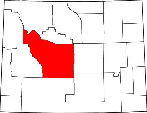 | |
| Towns | ||
| CDPs | ||
| Unincorporated communities | ||
| Ghost town | ||
| Indian reservation | ||
| ||
| Authority control |
|---|