Rutland County, Vermont
Rutland County is a county located in the U.S. state of Vermont. As of the 2010 census, the population was 61,642,[1] making it the second-most populous county in Vermont. Its county seat and most populous municipality is the city of Rutland.[2]
Rutland County | |
|---|---|
 | |
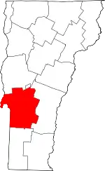 Location within the U.S. state of Vermont | |
 Vermont's location within the U.S. | |
| Coordinates: 43°35′42″N 73°03′11″W | |
| Country | |
| State | |
| Founded | 1781 |
| Named for | Rutland, Massachusetts |
| Shire Town | Rutland |
| Largest town | Rutland |
| Area | |
| • Total | 945 sq mi (2,450 km2) |
| • Land | 930 sq mi (2,400 km2) |
| • Water | 15 sq mi (40 km2) 1.6%% |
| Population (2010) | |
| • Total | 61,642 |
| • Estimate (2019) | 58,191 |
| • Density | 65/sq mi (25/km2) |
| Time zone | UTC−5 (Eastern) |
| • Summer (DST) | UTC−4 (EDT) |
| Congressional district | At-large |
History
On 16 February 1781 Rutland County was created from Bennington County.[3] From 26 June 1781 until 23 February 1782, Vermont attempted to annex part of New York east of the Hudson River (the so-called West Union); inhabitants in the area favored Vermont's township form of government, while Vermont hoped to gain bargaining power through expansion.[4] New York did not lose control of the area. For almost seven months Rutland County included part of Charlotte County (now Washington County), New York.[5]
In February 1783 Orange County gained the towns of Brookfield[6] and Randolph[7] and Windsor County gained the towns of Bethel[8] and Rochester[9] from Rutland. On 18 October 1785 Addison County was created from Rutland.[10]
On 27 February 1787 Windsor County gained the town of Stockbridge from Rutland,[11] then on 31 October 1792 Rutland gained from Windsor County when the town of Mount Holly was created from Jackson's Gore and the towns of Ludlow and Wallingford.[12] Windsor County gained Benton's Gore from Rutland on 2 March 1797.[13]
On 25 October 1805 Rutland County gained from Bennington County when the town of Mount Tabor gained from the town of Peru.[14] On 29 October 1806 Windsor County gained from Rutland County when the town of Rochester gained a small area from the town of Pittsfield.[15] On 15 November 1813 the county gained from Windsor County when the town of Pittsfield gained a small area from the town of Stockbridge, a change too small to appear on maps.[16] On 9 November 1814 Addison County gained from Rutland County when the town of Goshen gained from the town of Philadelphia.[17] On 22 October 1822 the county gained from Windsor County when the town of Pittsfield gained a small area from the town of Stockbridge.[18] On 3 November 1823 it gained from Windsor County again when the town of Shrewsbury gained a small area from the town of Plymouth.[19] On 15 November 1824 Windsor County gained from Rutland County when the town of Rochester gained a small area from the town of Pittsfield.[20] On 17 November 1825 Bennington County gained from the county when the town of Dorset gained a small area from the town of Mount Tabor.[21]
On 7 November 1839 the Legislature authorized Addison County to gain a small area from Rutland County when the town of Whiting was to gain from the town of Orwell. But there is no evidence that a change took effect.[22] Addison County gained the town of Orwell from Rutland County on 1 December 1847.[23] On 6 March 1855 Addison County gained another small area from the county when the town of Goshen gained "Clemens Land" from the town of Brandon.[24]
On 10 November 1870 the Legislature authorized Rutland County to gain a small area from Windsor County when the town of Mount Holly was to gain from the town of Weston. But there is no evidence that the change took effect.[25] On 7 April 1880 the county lost to Washington County, New York, when New York gained a small area west of the village of Fair Haven from Vermont due to a change in the course of the Poultney River, a change too small to see on most maps.[26] On 21 November 1884 Windsor County gained a small area from Rutland County when the town of Stockbridge gained Parker's Gore.[27] On 8 October 1895 Windsor County gained from the county when the town of Weston gained from the town of Mount Tabor.[28]
The county experienced the first outbreak of polio in the United States in 1894. Within weeks, 132 persons, mostly children, were paralyzed. An additional 18 had died.[29]
Geography
According to the U.S. Census Bureau, the county has a total area of 945 square miles (2,450 km2), of which 930 square miles (2,400 km2) is land and 15 square miles (39 km2) (1.6%) is water.[30] It is the second-largest county in Vermont by area. The primary stream of the county is Otter Creek, which runs through the county from the south to the north.
Adjacent counties
- Addison County - north
- Windsor County - east
- Bennington County - south
- Washington County, New York - west
National protected areas
Demographics
| Historical population | |||
|---|---|---|---|
| Census | Pop. | %± | |
| 1790 | 15,590 | — | |
| 1800 | 23,813 | 52.7% | |
| 1810 | 29,486 | 23.8% | |
| 1820 | 29,983 | 1.7% | |
| 1830 | 31,294 | 4.4% | |
| 1840 | 30,699 | −1.9% | |
| 1850 | 33,059 | 7.7% | |
| 1860 | 35,946 | 8.7% | |
| 1870 | 40,651 | 13.1% | |
| 1880 | 41,829 | 2.9% | |
| 1890 | 45,397 | 8.5% | |
| 1900 | 44,209 | −2.6% | |
| 1910 | 48,139 | 8.9% | |
| 1920 | 46,213 | −4.0% | |
| 1930 | 48,453 | 4.8% | |
| 1940 | 45,638 | −5.8% | |
| 1950 | 45,905 | 0.6% | |
| 1960 | 46,719 | 1.8% | |
| 1970 | 52,637 | 12.7% | |
| 1980 | 58,347 | 10.8% | |
| 1990 | 62,142 | 6.5% | |
| 2000 | 63,400 | 2.0% | |
| 2010 | 61,642 | −2.8% | |
| 2019 (est.) | 58,191 | [31] | −5.6% |
| U.S. Decennial Census[32] 1790–1960[33] 1900–1990[34] 1990–2000[35] 2010–2018[1] | |||
As of the 2010 census, there were 61,642 people, 25,984 households, and 16,018 families residing in the county.[36] The population density was 66.3 inhabitants per square mile (25.6/km2). There were 33,768 housing units at an average density of 36.3 per square mile (14.0/km2).[37] The racial makeup of the county was 97.1% white, 0.6% Asian, 0.5% black or African American, 0.2% American Indian, 0.2% from other races, and 1.3% from two or more races. Those of Hispanic or Latino origin made up 1.1% of the population.[36]
Of the 25,984 households, 25.9% had children under the age of 18 living with them, 47.3% were married couples living together, 9.9% had a female householder with no husband present, 38.4% were non-families, and 30.2% of all households were made up of individuals. The average household size was 2.28 and the average family size was 2.81. The median age was 44.3 years.[36]
The median income for a household in the county was $47,027 and the median income for a family was $58,790. Males had a median income of $40,638 versus $34,580 for females. The per capita income for the county was $25,426. About 8.1% of families and 11.8% of the population were below the poverty line, including 15.2% of those under age 18 and 8.5% of those age 65 or over.[38]
Politics
In 1828, Rutland County was won by National Republican Party candidate John Quincy Adams and by Henry Clay in 1832.
From William Henry Harrison in 1836 to Winfield Scott in 1852, the county would be won by Whig Party candidates.
From John C. Frémont in 1856 to Richard Nixon in 1960, the Republican Party would have a 104-year winning streak in the county.
In 1964, Rutland County was won by Democratic Party incumbent President Lyndon B. Johnson, who became the first Democratic presidential candidate to not only win the county, but to win the state of Vermont entirely.
Following the Democrats victory in 1964, the county went back to voting for Republican candidates for another 20 year winning streak starting with Richard Nixon in 1968 and ending with George H. W. Bush in 1988, who became the last Republican presidential candidate to win the county.
In 1992 the county was won by Bill Clinton and has been won by Democratic candidates ever since. Despite this, Rutland County has proven to be relatively close in some recent presidential elections. For instance, in 2000, Al Gore won the county by a narrow margin of 1.6% while John Kerry in 2004 won the county by 4.7% and Hillary Clinton won the county by 3.9% in 2016.
| Year | Republican | Democratic | Third parties |
|---|---|---|---|
| 2020 | 43.2% 14,672 | 53.7% 18,230 | 3.1% 1,068 |
| 2016 | 42.1% 12,479 | 46.0% 13,635 | 11.8% 3,501 |
| 2012 | 37.9% 10,835 | 59.7% 17,088 | 2.4% 686 |
| 2008 | 36.6% 11,584 | 61.2% 19,355 | 2.1% 678 |
| 2004 | 46.6% 14,440 | 51.3% 15,904 | 2.0% 631 |
| 2000 | 46.1% 13,546 | 47.7% 13,990 | 6.2% 1,826 |
| 1996 | 36.5% 9,934 | 48.6% 13,230 | 14.9% 4,065 |
| 1992 | 35.2% 10,963 | 41.2% 12,829 | 23.6% 7,352 |
| 1988 | 55.2% 14,482 | 43.8% 11,496 | 1.1% 283 |
| 1984 | 61.0% 15,236 | 38.2% 9,545 | 0.8% 204 |
| 1980 | 46.0% 11,142 | 39.6% 9,596 | 14.4% 3,496 |
| 1976 | 53.0% 11,565 | 45.2% 9,868 | 1.8% 386 |
| 1972 | 62.7% 14,143 | 36.6% 8,261 | 0.7% 159 |
| 1968 | 51.3% 10,318 | 44.7% 9,000 | 4.0% 809 |
| 1964 | 35.1% 7,165 | 64.9% 13,241 | |
| 1960 | 56.8% 12,166 | 43.2% 9,246 | |
| 1956 | 73.8% 14,570 | 26.2% 5,165 | |
| 1952 | 70.0% 13,980 | 29.9% 5,970 | 0.2% 36 |
| 1948 | 60.6% 10,206 | 38.3% 6,452 | 1.2% 195 |
| 1944 | 57.3% 9,544 | 42.7% 7,111 | |
| 1940 | 55.0% 10,829 | 44.7% 8,798 | 0.3% 54 |
| 1936 | 52.9% 10,794 | 46.8% 9,543 | 0.3% 54 |
| 1932 | 54.2% 10,821 | 44.7% 8,924 | 1.0% 206 |
| 1928 | 59.4% 12,621 | 40.5% 8,609 | 0.2% 32 |
| 1924 | 74.3% 10,642 | 17.3% 2,477 | 8.4% 1,201 |
| 1920 | 73.1% 8,940 | 26.1% 3,192 | 0.8% 97 |
| 1916 | 66.4% 5,926 | 31.2% 2,785 | 2.5% 221 |
| 1912 | 36.0% 2,999 | 25.0% 2,079 | 39.0% 3,246[40] |
| 1908 | 75.7% 5,643 | 20.7% 1,542 | 3.6% 269 |
| 1904 | 77.1% 5,772 | 18.3% 1,367 | 4.6% 345 |
| 1900 | 74.7% 5,901 | 23.7% 1,874 | 1.6% 129 |
| 1896 | 78.0% 6,794 | 19.1% 1,661 | 2.9% 255 |
| 1892 | 66.5% 5,210 | 31.0% 2,426 | 2.5% 199 |
| 1888 | 68.6% 6,088 | 27.2% 2,417 | 4.2% 373 |
| 1884 | 66.7% 5,096 | 29.5% 2,253 | 3.9% 294 |
| 1880 | 69.8% 5,690 | 29.7% 2,421 | 0.5% 42 |
Transportation
Air
The Rutland – Southern Vermont Regional Airport is located just south of Rutland city in North Clarendon. It is a commercial airport providing three flights daily to Boston.
Rail
Passenger rail service is provided by Amtrak via the Ethan Allen Express which connects Rutland with Albany and New York City. There are two train stations in Rutland County served by this route: the Castleton station and Rutland station.
Bus
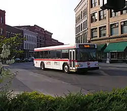
The Marble Valley Regional Transit District provides "The Bus" with service to the city of Rutland and the towns of Rutland, West Rutland, Castleton, Fair Haven, Poultney, Proctor, and Killington, as well as commuter service to Ludlow, Middlebury and Manchester.
Premier Coach's Vermont Translines serves Rutland daily with two intercity bus connections between Burlington, Lebanon, New Hampshire and Albany, New York in a partnership with Greyhound.[41] They also serve Wallingford, Brandon, Mendon and Killington along the two routes.
Highway
 U.S. Route 4 enters Rutland County in Fair Haven from the west. It continues east as a four-lane expressway for 19 miles to Rutland city with 6 exits serving Fair Haven, Castleton, and Rutland. It then continues east from Rutland through Killington into Windsor County.
 U.S. Route 7 enters Rutland County from the south in the town of Mount Tabor and continues north through Wallingford and Clarendon to Rutland city. For 10 miles south of Rutland, Route 7 is a divided highway. It then continues north through Pittsford and Brandon before entering Addison County.
 Vermont Route 3 is a 7.8 north–south highway that extends north from Rutland Center through Proctor and into Pittsford terminating at US Route 7.
 Vermont Route 4A is the old alignment of US Route 4 and parallels that highway from Fair Haven through Castleton before terminating in West Rutland.
 Vermont Route 22A is a north–south highway entering the county in Fair Haven from the New York state line and passing through West Haven and Benson before continuing into Addison County.
 Vermont Route 30 is a north–south highway entering the county in Pawlet from Bennington County and continuing north through Poultney, Castleton, Hubbardton, and Sudbury before continuing into Addison County.
 Vermont Route 31 is a 5.5 mile highway from the New York state line in Wells to the village of Poultney.
 Vermont Route 53 is a short north–south highway that extends north from Route 73 in the Brandon village of Forestdale toward Lake Dunmore in Addison County.
 Vermont Route 73 is an east–west highway extending from the county line with Addison County through Sudbury and Brandon and then returning to Addison County.
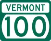 Vermont Route 100 is a north–south highway entering from Windsor County to the south through Killington and then returning to Windsor County.
 Vermont Route 103 is a north–south highway entering from Windsor County to the south in Mount Holly and extending north through Wallingford and Clarendon before terminating at Route 7.
 Vermont Route 133 is a 22-mile north–south highway completely within Rutland County. It extends north from Pawlet through Middletown Springs and Tinmouth before terminating at Vermont 4A in West Rutland.
 Vermont Route 140 is an east–west highway crossing the county east from Poultney through Middletown Springs, Tinmouth, and Wallingford before terminating at Route 103 in Mount Holly.
 Vermont Route 144 is a 6.8 mile east–west highway extending from Route 22A in Benson through Hubbardton past Lake Hortonia before terminating at Route 30 in Sudbury.
 Vermont Route 149 is an east–west highway extending from the New York state line for only 1.3 miles to Vermont 30 in Pawlet.
 Vermont Route 155 is a north–south highway continuing north from Windsor County in the town of Mount Holly and then terminating in Wallingford at Route 103.
Communities
City
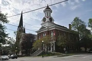
- Rutland (shire town)
Towns
Census-designated places
Villages
- Belmont, in the town of Mount Holly
- Florence, in the town of Pittsford
- Hortonia, in the town of Hubbardton
- Hortonville, in the town of Mount Holly
- Poultney village, in the town of Poultney
See also
Footnotes
- "State & County QuickFacts". United States Census Bureau. Retrieved December 30, 2013.
- "Find a County". National Association of Counties. Retrieved June 7, 2011.
- Vermont State Papers, 13:5-6.
- Vt. State Papers, 13:45-46; Newton, 83-87; Williamson, C., 101-102.
- Vt. State Papers, 3, pt. 2: 67-68.
- Vt. State Papers, 13:174.
- Vt. Laws 1783 in Vt. State Papers, 13: 191.
- Vt. State Papers, 3, pt. 2:155.
- Vt. State Papers, 13:183.
- Vt. State Papers, 14:33-34.
- Vt. State Papers, 14:173-175.
- Vt. State Papers, 15:88-90.
- McCarty, "Evolution," 122-123; Vt. Laws, Revised and Passed 1797, ch. 6/pp. 129-133.
- McCarty, "Evolution," 134; Vt. Laws 1805, ch. 15/pp. 19-20.
- Vt. Laws 1806, ch. 28/pp. 36-37.
- Vt. Laws 1813, ch. 102/p. 144.
- Vt. Laws 1814, ch. 96/pp. 111-112.
- Vt. Laws 1822, ch. 37/p. 36.
- Vt. Laws 1823, ch. 2/pp. 3-4.
- Vt. Laws 1824, ch. 14/p. 16.
- McCarty, "Evolution," 140; Vt. Laws 1825, no 18/p. 25; Vt. Laws 1832, no. 25/p. 25.
- Vt. Laws 1839, no. 37/pp. 87-88.
- Vt. Laws 1847, no. 8/p. 7.
- Vt. Laws 1854, no. 61, sec. 3/p. 59.
- Vt. Laws 1870, no. 292/pp. 572-573.
- Vt. Laws 1876, no. 201/p. 380; U.S. Stat., vol. 21, ch. 49 [1880]/p. 72; Van Zandt, 65.
- Vt. Laws 1884, no. 262/p. 270.
- "Weston v. Mount Tabor."
- Dhruv Khullar (September 8, 2020). "It Will Take More Than a Vaccine to Beat COVID-19". New Yorker. New Yorker. Retrieved September 9, 2020.
- "2010 Census Gazetteer Files". United States Census Bureau. August 22, 2012. Retrieved June 29, 2015.
- "Population and Housing Unit Estimates". Retrieved May 21, 2019.
- "U.S. Decennial Census". United States Census Bureau. Retrieved June 29, 2015.
- "Historical Census Browser". University of Virginia Library. Retrieved June 29, 2015.
- Forstall, Richard L., ed. (March 27, 1995). "Population of Counties by Decennial Census: 1900 to 1990". United States Census Bureau. Retrieved June 29, 2015.
- "Census 2000 PHC-T-4. Ranking Tables for Counties: 1990 and 2000" (PDF). United States Census Bureau. April 2, 2001. Retrieved June 29, 2015.
- "DP-1 Profile of General Population and Housing Characteristics: 2010 Demographic Profile Data". United States Census Bureau. Archived from the original on February 13, 2020. Retrieved January 20, 2016.
- "Population, Housing Units, Area, and Density: 2010 - County". United States Census Bureau. Archived from the original on February 13, 2020. Retrieved January 20, 2016.
- "DP03 SELECTED ECONOMIC CHARACTERISTICS – 2006-2010 American Community Survey 5-Year Estimates". United States Census Bureau. Archived from the original on February 13, 2020. Retrieved January 20, 2016.
- Leip, David. "Dave Leip's Atlas of U.S. Presidential Elections". uselectionatlas.org. Retrieved 7 April 2018.
- The leading "other" candidate, Progressive Theodore Roosevelt, received 2,927 votes, while Socialist candidate Eugene Debs received 240 votes, Prohibition candidate Eugene Chafin received 79 votes.
- "VT TRANSLINES BUS SCHEDULE". Vermont Translines. Retrieved 25 February 2015.
Further reading
- Juliette M. Bianco and Pieter B.F.J. Broucke, Nature Transformed: Edward Burtynsky's Vermont Quarry Photographs in Context. Hanover, NH: Hood Museum of Art, Dartmouth College; Distributed by University Press of New England, 2012.
- David C. Gale, Proctor: the Story of a Marble Town. Brattleboro, VT: Vermont Printing Co, 1922.
- Abby Marin Hemenway (ed.), The History of Rutland County, Vermont: Civil, Ecclesiastical, Biographical, and Military. White River Junction, VT: White River Paper Co., 1882.
- Paul R Magocsi, Immigrants from Eastern Europe: The Carpatho-Rusyn Community of Proctor, Vermont. Montpelier, VT: Vermont Historical Society, 1974.
- Lyman Williams Redington, Centennial Celebration of the Organization of Rutland County, Vermont: Held under the Auspices of the Rutland County Historical Society at the Town Hall, Rutland, Vt., March 4, 1881... Rutland, VT: L.W. Redington, 1882.
- H.P. Smith and W.S. Rann, History of Rutland County, Vermont: With Illustrations and Biographical Sketches of Some of Its Prominent Men and Pioneers. Syracuse, NY: D. Mason and Co., 1886.
- Vermont Marble Company, Vermont Marble Company: Its Past and Future: Address at a General Conference at Proctor, Vermont, December 28–31, 1920. Proctor, VT: Privately printed, 1921.
External links
| Wikimedia Commons has media related to Rutland County, Vermont. |
- Rutland County Chamber of Commerce
- National Register of Historic Places listing for Rutland Co., Vermont
- National Association of Counties for Rutland Co., Vermont
- Census Bureau Quick Facts for Rutland Co., Vermont
Places adjacent to Rutland County, Vermont | ||||||||||
|---|---|---|---|---|---|---|---|---|---|---|
| ||||||||||
Municipalities and communities of Rutland County, Vermont, United States | ||
|---|---|---|
| City | Map of Vermont highlighting Rutland County | |
| Towns | ||
| Village | ||
| CDPs | ||
| Other communities | ||
| ||
Montpelier (capital) | ||
| Regions | ||
| Counties | ||
| Cities | ||
| Towns (pop. >5000) | ||
| Festivals | ||
| Topics |
| |
| Society |
| |
| Authority control |
|---|