Essex County, Vermont
Essex County is a county located in the northeastern part of the U.S. state of Vermont. As of the 2010 census, the population was 6,306,[1] making it the least-populous county in both Vermont and New England. Its shire town (county seat) is the municipality of Guildhall.[2] The county was created in 1792 and organized in 1800.[3] Bordered by the Connecticut River next to New Hampshire, Essex County is south of the Canadian province of Quebec. It is the county with the lowest household-income in Vermont.
Essex County | |
|---|---|
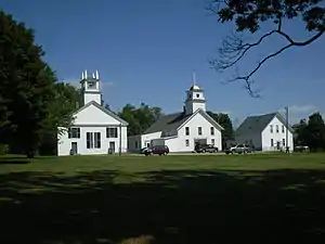 Essex County Courthouse in Guildhall | |
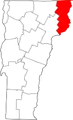 Location within the U.S. state of Vermont | |
 Vermont's location within the U.S. | |
| Coordinates: 44°43′15″N 71°44′42″W | |
| Country | |
| State | |
| Founded | 1800 |
| Named for | Essex |
| Shire Town | Guildhall |
| Largest town | Lunenburg |
| Area | |
| • Total | 675 sq mi (1,750 km2) |
| • Land | 664 sq mi (1,720 km2) |
| • Water | 12 sq mi (30 km2) 1.7%% |
| Population (2010) | |
| • Total | 6,306 |
| • Estimate (2019) | 6,163 |
| • Density | 9.3/sq mi (3.6/km2) |
| Time zone | UTC−5 (Eastern) |
| • Summer (DST) | UTC−4 (EDT) |
| Congressional district | At-large |
History
Prior to the arrival of colonists of European descent, the area was populated by the Abenakis. They used the Connecticut and Nulhegan rivers as primary means of travel through the area along with many subsidiary rivers and streams. The culture was mostly hunter-gatherer with a combination of agriculture, hunting and fishing. While the rivers provided good fishing the primary food animal was moose.[4]
Vermont was divided into two counties in March 1778. In 1781 the legislature divided the northernmost county, Cumberland, into three counties: Windham and Windsor, in approximately the modern location for those counties. The northern remainder was called Orange County. This latter tract nearly corresponded with the old New York county of Gloucester, organized by that province March 16, 1770, with Newbury as the shire town.[5]
On September 3, 1783, as a result of the signing of the Treaty of Paris, the Revolutionary War ended with Great Britain recognizing the independence of the United States. Vermont's border with Quebec was established at 45 degrees north latitude.[6][7]
On November 5, 1792, the legislature divided Chittenden and Orange counties into six separate counties, as follows: Chittenden, Orange, Franklin, Caledonia, Essex, and Orleans.[5] No reason is given for the county being named after the county of Essex in England.[8]
In 1999, a group of investors bought 86,212 acres (34,889 ha) from Champion International Paper for $7.5 million, covering parts of fourteen towns in the county. The state of Vermont and the Freeman Foundation purchased easements for $8.5 million to guarantee traditional uses of the land for logging and recreation. In 2008, Plum Creek Timber company announced plans to purchase this property.[9]
A murder trial was held at the county courthouse in 1923, which was the last murder trial. In 1973, a non-resident murdered another non-resident.[10] In 2008, two residents died by homicide – the first in 85 years – when police said a young woman was shot by her boyfriend and a 59-year-old man shot his mother.[11]
In 2012, a study indicated that county residents, overall, were the least healthy in the state. The rating was based on premature death, low birth weight, smoking, obesity, inactivity, excessive drinking, car crashes, sexually transmitted diseases, graduation rates, poverty, violent crime rates, air pollution, limited access to healthy food, unemployment, and the number of single parent households.[12]
Demographics
| Historical population | |||
|---|---|---|---|
| Census | Pop. | %± | |
| 1800 | 1,479 | — | |
| 1810 | 3,087 | 108.7% | |
| 1820 | 3,284 | 6.4% | |
| 1830 | 3,981 | 21.2% | |
| 1840 | 4,226 | 6.2% | |
| 1850 | 4,650 | 10.0% | |
| 1860 | 5,786 | 24.4% | |
| 1870 | 6,811 | 17.7% | |
| 1880 | 7,931 | 16.4% | |
| 1890 | 9,511 | 19.9% | |
| 1900 | 8,056 | −15.3% | |
| 1910 | 7,384 | −8.3% | |
| 1920 | 7,364 | −0.3% | |
| 1930 | 7,067 | −4.0% | |
| 1940 | 6,490 | −8.2% | |
| 1950 | 6,257 | −3.6% | |
| 1960 | 6,083 | −2.8% | |
| 1970 | 5,416 | −11.0% | |
| 1980 | 6,313 | 16.6% | |
| 1990 | 6,405 | 1.5% | |
| 2000 | 6,459 | 0.8% | |
| 2010 | 6,306 | −2.4% | |
| 2019 (est.) | 6,163 | [13] | −2.3% |
| U.S. Decennial Census[14] 1790–1960[15] 1900–1990[16] 1990–2000[17] 2010–2018[1] | |||
An estimated 1,000 military veterans reside in the county.[18]
2010 census
As of the 2010 United States Census, there were 6,306 people, 2,818 households, and 1,814 families residing in the county.[19] The population density was 9.5 inhabitants per square mile (3.7/km2). There were 5,019 housing units at an average density of 7.6 per square mile (2.9/km2).[20]
Of the 2,818 households, 24.2% had children under the age of 18 living with them, 51.0% were married couples living together, 8.7% had a female householder with no husband present, 35.6% were non-families, and 29.3% of all households were made up of individuals. The average household size was 2.23 and the average family size was 2.70. The median age was 47.4 years.[19]
The median income for a household in the county was $37,734 and the median income for a family was $46,263. Males had a median income of $37,021 versus $28,710 for females. The per capita income for the county was $20,040. About 13.0% of families and 16.9% of the population were below the poverty line, including 25.8% of those under age 18 and 10.3% of those age 65 or over.[21]
Geography
According to the U.S. Census Bureau, the county has a total area of 675 square miles (1,750 km2), of which 664 square miles (1,720 km2) is land and 12 square miles (31 km2) (1.7%) is water.[22]
In the north central portion of the county the Nulhegan Basin is a circular area roughly 10 miles (16 km) in diameter. While the origin of this basin may be either an asteroid hit or ancient volcano it has not been proven as either one so far. Within the basin is a bog and the Silvio O. Conte Fish and Wildlife Refuge with a visitor center, hiking trails, and viewing platforms where one can wait under shelter in hopes of spotting a moose or other wildlife.
The county has many mountains and waterways. The Northern Forest Canoe Trail passes through this area along the Clyde, Nulhegan, and Connecticut rivers.
Adjacent counties
- Coös County, New Hampshire – east
- Grafton County, New Hampshire – south
- Caledonia County – southwest
- Orleans County – west
- Coaticook Regional County Municipality, Quebec – north
Fauna
In 2011, there were about 1,000 moose in the county. State officials estimated that this was about the "correct number" for a sustainable herd, with the moose not showing signs of starvation, nor the feeding grounds showing signs of overgrazing.[4] In recent years the moose population has been suffering from infestations by ticks. Some moose have been found having as many as 10,000 ticks on one moose, thus causing death. Warmer winter weather in recent years has prevented the normal die-off of ticks from freezing.
National protected area
Government
The Essex-Orleans Senate district includes all of Essex County, as well as Orleans County. It is represented in the Vermont Senate by John S. Rodgers and Robert A. Starr, both Democrats.
The elected officials of the county as of the 2018 elections are as follows:
| Position[23] | Name | Party | First elected |
|---|---|---|---|
| State Senator | Robert A. Starr | Democratic | 2004 |
| John S. Rodgers | Democratic | 2012 | |
| State Rep District 1 | Connie Quimby | Republican | 2012 |
| State Rep District 2 | Paul D. Lefebvre | Republican | 2014 |
| State's Attorney | Vincent Illuzzi | Prog/Rep/Dem/Lib | 1998 |
| Assistant Judge | Calvin Colby | Republican | 2010 |
| Allen D. Hodgdon | Republican | 2014 | |
| Probate Judge | Allen D. Hodgdon | Republican | 2010 |
| Sheriff | Trevor Colby | Rep/Prog | 2010 |
| High Bailiff | Vacant | N/A | since 2012 |
| Justices of the Peace: |

| Town | Name | Party | First elected |
|---|---|---|---|
| Bloomfield 5 | Sharon Belknap | Republican | 2014 |
| Martin Lomansey | Independent | 2012 | |
| Raymond Bowen Jr. | Independent | 2014 | |
| Steven Bunnell | Republican | 2016 | |
| Suzanne Routhier | Independent | 2006 | |
| Brighton 7 | Krystyna Kurzej | Democratic | 2016 |
| Stephanie Nagle | Democratic | 2012 | |
| Janet Osborne | Democratic | 2014 | |
| Peder Pederson | Independent | 2014 | |
| Susan Pederson | Independent | 2012 | |
| David Robbins | Republican | 2014 | |
| Dolores Robbins | Republican | 2014 | |
| Brunswick 5 | Sharon Graham | Independent | 2008 |
| Claudette Hook | Independent | 2012 | |
| June Hook | Independent | 2012 | |
| Deborah Tetreault | Independent | 2010 | |
| Janet Washburn | Independent | 2016 | |
| Canaan 7 | Martha Allen | Democratic | 2012 |
| Irving Cullivan | Democratic | 2012 | |
| Michael Daley | Democratic | 2014 | |
| Renee Marchesseault | Republican | 2004 | |
| Judith Masson | Democratic | 2008 | |
| Fern Owen Brown | Democratic | 2016 | |
| Vacant | N/A | ||
| Concord 5 | Linda Blakslee | Republican | 2012 |
| Paula N. Christopher | Republican | 2018 | |
| Mary Gochie | Republican | 2010 | |
| Nancy Goodwin | Republican | 2008 | |
| Arlene Hovey | Republican | 2012 | |
| East Haven 5 | Robert J. Burke | Democratic | 2008 |
| Franklin Higgins | Independent | 2014 | |
| Michael Masure | Republican | 2012 | |
| Delbert Reed | Republican | 2016 | |
| Bonnie Ricci | Democratic | 2014 | |
| Granby 5 | Bruce Berryman | Republican | 2016 |
| Reginald Bunnell | Republican | 2012 | |
| Calvin Noble | Republican | 2006 | |
| John Noble | Republican | 2008 | |
| Sonia Peters | Republican | 2008 | |
| Guildhall 5 | Casey Dowland | Republican | 2014 |
| Valerie Foy | Democratic | 2010 | |
| Kelly McLain | Republican | 2016 | |
| Alfred McVetty | Republican | 2014 | |
| Jacqueline Spillane | Republican | 2018 | |
| Lemington 5 | Myra Ellingwood | Democratic | 2012 |
| Walter Noyes | Independent | 2010 | |
| Michelle Thibault | Republican | 2018 | |
| Mary Jane Walker | Republican | 2016 | |
| Linda Young | Democratic | 2016 | |
| Lunenburg 5 | Maren Downing | Republican | 2014 |
| Gisele Hallee | Independent | 2016 | |
| Patricia Kenny | Republican | 2008 | |
| James Peyton | Independent | 2016 | |
| Barbara Willson | Independent | 2016 | |
| Maidstone 3 | Bruce Hobaugh | Independent | 2012 |
| Cheryl McVetty | Independent | 2016 | |
| Gail Tattan Giampalo | Independent | 2016 | |
| Norton 5 | Janice Daniels | Republican | 2016 |
| Betsy Fontaine | Republican | 2018 | |
| Andre Gagnon | Republican | 2016 | |
| Franklin Henry | Republican | 2012 | |
| Kenneth Stransky | Republican | 2016 | |
| Victory 5 | Zane Cooke | Independent | 2014 |
| Laurie Gilman | Republican | 2018 | |
| Howard Lynaugh | Independent | 2016 | |
| Sylvia McKinstry | Republican | 2016 | |
| Lori Miller | Independent | 2016 |
Elections
In 1828, Essex County voted for National Republican Party candidate John Quincy Adams.
Andrew Jackson would win the county in 1832 while Martin Van Buren would win it in 1836, making them the first Democrats to carry the county.
From William Henry Harrison in 1840 to Winfield Scott in 1852, the county would vote the Whig Party candidates.
From John C. Frémont in 1856 to Alf Landon in 1936, the Republican Party would have an 80-year winning streak in the county.
In 1940 and 1944, Essex County would be won by Franklin D. Roosevelt.
Thomas E. Dewey would win the county in 1948 while Dwight D. Eisenhower and Richard Nixon would win it in 1952, 1956 and 1960, respectively.
In 1964, the county was won by incumbent President Lyndon B. Johnson.
Following the Democrats victory in 1964, the county went back to voting for Republican candidates for another 20 year winning streak starting with Richard Nixon in 1968 and ending with George H. W. Bush in 1988.
From 1980 on, Essex County has been as a bellwether county, consistently backing the national winner.
In 1992 and 1996, the county was won by Bill Clinton while in 2000, it was one of the four counties in Vermont to be won by George W. Bush.
In 2004, Essex County was the only county in Vermont to vote for George W. Bush, by 10.7% over John Kerry, who won statewide by a 20.1% advantage.[25]
In 2008, Essex voted for Barack Obama by a 14.5% margin over John McCain, while Obama carried the state by 37%. In 2012, Barack Obama won the county again by a similar margin.[26]
In 2016, it was the only county in Vermont that voted for Donald Trump, by 18% over Hillary Clinton, who won the state by 28.5%.[27]
In 2020, it was similarly the only county to vote for Donald Trump in Vermont, the first time it backed a losing presidential candidate since 1976, when it backed Gerald Ford over Jimmy Carter.
| Year | Republican | Democratic | Third parties |
|---|---|---|---|
| 2020 | 53.9% 1,773 | 42.7% 1,405 | 3.3% 110 |
| 2016 | 51.5% 1,506 | 34.8% 1,019 | 13.7% 400 |
| 2012 | 41.6% 1,164 | 55.0% 1,539 | 3.4% 95 |
| 2008 | 41.4% 1,284 | 55.9% 1,733 | 2.7% 84 |
| 2004 | 54.2% 1,591 | 43.5% 1,276 | 2.4% 70 |
| 2000 | 54.1% 1,564 | 39.0% 1,129 | 6.9% 199 |
| 1996 | 33.4% 819 | 45.7% 1,120 | 20.8% 510 |
| 1992 | 34.7% 1,038 | 36.5% 1,092 | 28.9% 866 |
| 1988 | 64.2% 1,535 | 35.0% 837 | 0.8% 19 |
| 1984 | 69.5% 1,632 | 29.5% 693 | 1.0% 24 |
| 1980 | 55.8% 1,305 | 34.2% 799 | 10.1% 236 |
| 1976 | 53.0% 1,161 | 45.8% 1,002 | 1.2% 26 |
| 1972 | 68.3% 1,441 | 31.0% 655 | 0.7% 14 |
| 1968 | 49.8% 1,009 | 47.0% 952 | 3.2% 64 |
| 1964 | 31.0% 750 | 69.1% 1,673 | |
| 1960 | 57.5% 1,439 | 42.5% 1,063 | |
| 1956 | 70.4% 1,714 | 29.5% 719 | 0.0% 1 |
| 1952 | 69.0% 1,592 | 30.6% 705 | 0.4% 9 |
| 1948 | 54.2% 1,055 | 45.3% 881 | 0.5% 10 |
| 1944 | 48.6% 1,064 | 51.4% 1,126 | |
| 1940 | 47.0% 1,365 | 52.7% 1,531 | 0.4% 11 |
| 1936 | 55.0% 1,474 | 44.9% 1,203 | 0.1% 3 |
| 1932 | 52.6% 1,567 | 46.9% 1,397 | 0.5% 16 |
| 1928 | 67.7% 1,703 | 32.0% 805 | 0.2% 6 |
| 1924 | 63.6% 1,391 | 26.3% 576 | 10.1% 220 |
| 1920 | 68.9% 1,243 | 30.6% 552 | 0.5% 9 |
| 1916 | 56.8% 734 | 42.1% 544 | 1.2% 15 |
| 1912 | 39.0% 463 | 29.3% 348 | 31.7% 376 |
| 1908 | 68.1% 744 | 29.9% 327 | 2.0% 22 |
| 1904 | 75.5% 750 | 23.5% 233 | 1.0% 10 |
| 1900 | 67.5% 758 | 31.9% 358 | 0.6% 7 |
| 1896 | 73.0% 873 | 23.2% 277 | 3.9% 46 |
| 1892 | 61.4% 721 | 35.6% 418 | 3.1% 36 |
| 1888 | 61.6% 907 | 34.1% 502 | 4.3% 63 |
| 1884 | 61.5% 898 | 34.2% 500 | 4.3% 63 |
| 1880 | 64.1% 853 | 35.5% 472 | 0.4% 5 |
Economy
Personal income
The median income for a household in the county was $30,490, and the median income for a family was $34,984. Males had a median income of $27,929 versus $20,583 for females. The per capita income for the county was $14,388. About 9.90% of families and 13.70% of the population were below the poverty line, including 17.30% of those under age 18 and 12.90% of those age 65 or over.
The median wage is the lowest in the state, and that status is expected to continue through 2010.[28]
Housing
In 2007, Essex was the only county in the state to have a positive Housing Affordability Index on housing; i.e. the average household can afford to buy the average house. That said, both figures are the lowest in the state.[29]
Media
WVTI 106.9 broadcasts from Island Pond, Vermont.[30]
Communities
Towns
Census-designated places
Unincorporated communities
In Vermont, gores and grants are unincorporated portions of a county which are not part on any town and have limited self-government (if any, as many are uninhabited).
References
- "State & County QuickFacts". United States Census Bureau. Archived from the original on August 6, 2011. Retrieved December 30, 2013.
- "Find a County". National Association of Counties. Archived from the original on May 31, 2011. Retrieved June 7, 2011.
- "Vermont: Individual County Chronologies". Vermont Atlas of Historical County Boundaries. The Newberry Library. 2008. Retrieved June 30, 2015.
- Starr, Tina (October 19, 2011). "Biologists keep close watch on moose herd". the Chronicle. Barton, Vermont. p. 20.
- Gazetteer of Lamoille and Orleans Counties, VT.; 1883–1884. Hamilton Child. May 1887.
- Van Zandt, Franklin K. Boundaries of the United States and the Several States. Geological Survey Professional Paper 909. Washington, DC; Government Printing Office, 1976. The Standard Compilation for its subject. P. 12.
- Parry, Clive, ed. Consolidated Treaty Series. 231 Volumes. Dobbs Ferry, New York; Oceana Publications, 1969–1981. Volume 48; pp. 481; 487; 491–492.
- Orleans County, Vermont: History and Information Archived September 28, 2011, at the Wayback Machine. E-referencedesk.com. Retrieved on April 12, 2014.
- Sutkowski, Matt (September 16, 2008). 86,212 acre land sale in works. Burlington Free Press.
- Ring, Wilson (September 15, 2008). Slaying a novelty for county. Burlington Free Press.
- Silverman, Adam (January 1, 2009). Vermont killings jumped. Burlington Free Press.
- Starr, Tena (April 11, 2012). "Essex is least healthy county in Vermont". the Chronicle. Barton, Vermont. p. 1.
- "Population and Housing Unit Estimates". Retrieved May 21, 2019.
- "U.S. Decennial Census". United States Census Bureau. Retrieved June 28, 2015.
- "Historical Census Browser". University of Virginia Library. Retrieved June 28, 2015.
- Forstall, Richard L., ed. (March 27, 1995). "Population of Counties by Decennial Census: 1900 to 1990". United States Census Bureau. Retrieved June 28, 2015.
- "Census 2000 PHC-T-4. Ranking Tables for Counties: 1990 and 2000" (PDF). United States Census Bureau. April 2, 2001. Retrieved June 28, 2015.
- The Chronicle, July 1, 2009, page 14, "Veterans ask for clinic closer to home," Joseph Gresser
- "DP-1 Profile of General Population and Housing Characteristics: 2010 Demographic Profile Data". United States Census Bureau. Archived from the original on February 13, 2020. Retrieved January 20, 2016.
- "Population, Housing Units, Area, and Density: 2010 - County". United States Census Bureau. Archived from the original on February 13, 2020. Retrieved January 20, 2016.
- "DP03 SELECTED ECONOMIC CHARACTERISTICS – 2006-2010 American Community Survey 5-Year Estimates". United States Census Bureau. Archived from the original on February 13, 2020. Retrieved January 20, 2016.
- "2010 Census Gazetteer Files". United States Census Bureau. August 22, 2012. Retrieved June 28, 2015.
- http://vtelectionarchive.sec.state.vt.us/
- https://www.sec.state.vt.us/elections/town-meeting-local-elections.aspx
- "2004 Presidential General Election Results - Vermont". uselectionatlas.org.
- Leip, David. "Dave Leip's Atlas of U.S. Presidential Elections". uselectionatlas.org. Retrieved March 26, 2018.
- "Presidential Election Results: Donald J. Trump Wins". The New York Times. August 9, 2017. ISSN 0362-4331. Retrieved March 26, 2018.
- "Vermont Department of Housing and Community Affairs" (PDF). Vermont Statewide Trends. Retrieved January 5, 2007.
- Braithwaite, Chris (December 19, 2007). Vermont law prohibits pre-payment penalties. the Chronicle.
- VPR (October 28, 2008). VPR Classical broadcasts from I.P. the Chronicle.
External links
- National Register of Historic Places listing for Essex Co., Vermont
- Philip, Abenaki Indian Chief, and Philip’s Grant (Orleans and Essex Counties)
Places adjacent to Essex County, Vermont | |
|---|---|
Municipalities and communities of Essex County, Vermont, United States | ||
|---|---|---|
| Towns | Map of Vermont highlighting Essex County | |
| CDPs | ||
| Grants and gores | ||
| Other communities | ||
| Footnotes | ‡ Unorganized | |
| ||
Montpelier (capital) | ||
| Regions | ||
| Counties | ||
| Cities | ||
| Towns (pop. >5000) | ||
| Festivals | ||
| Topics |
| |
| Society |
| |
| Authority control |
|---|