Sandow, Chiktan
Sandow is the highest village of Chiktan block, situated 60 kilometres (37 mi) away in the east of district headquarter Kargil, Ladakh. Sandow is surrounded by villages - Lamsoo in the west, Yokma Kharboo and Shakar in the south and Lhalung Batalik in the north.[2] Sandow falls under the Shakar constituency zone. The village is 58 kilometres (36 mi) from Kargil town, located on 34.55 latitude and 76.38 longitude and at an altitude of 3,200 metres (10,500 ft) above mean sea level. The village was settled some around 300 years before, on a syncline of a complex range of Himalaya.
Sandow | |
|---|---|
Village | |
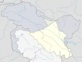 Sandow Location in Ladakh, India  Sandow Sandow (India) | |
| Coordinates: 34.55°N 76.38°E | |
| Country | India |
| Union Territory | Ladakh |
| District | Kargil |
| Tehsil | Shakar-Chiktan[1] |
| Population (2011) | |
| • Total | 400 |
| Time zone | UTC+5:30 (IST) |
Climate
Sandow has very cool climate with temperature dropping to −30 °C (−22 °F) in winter. Very cool normal wind makes life harsh there in winter. In summer temperature rises to 20. Three main seasons i.e. spring, autumn and winter are very cold. In winter snowfall of over 1 feet will be there which is the main source of water for the summer. There is a large like namely Shashi Lake 2 km above the village which stores snow water melted in spring and early summer to ensure continuous water supply for the whole summer.
Agriculture
Agriculture is very important and main work of the villagers. Crops like Barley, wheat and pea are cultivated. Agricultural works begins in mid-April until August. There are canals to water fields as there used to be very less rainfall. Until a few years back all agricultural works like ploughing, threshing, grinding to flour are used to be done by peoples with help of animals but now machines replaced grinding and threshing.
Topography
Sandow is in between mountains and is very rugged. Small agricultural fields are made in the mountains alongside the stream. Soil here is not productive, basically soil is very new, formed by degradation and erosion of mountains peoples have made the soil cultivable by fediing the soil with local manures whole village and field are in slope of mountains.
Education
There is a middle school in the village. Literacy rate of the village is above 80% and most of the students are pursuing their higher studies in various parts of India. A secondary school is located 10 kilometres (6.2 mi) away from the village in another village Shakar.
Population
There are about 40 households in the villages and population is roughly 400.
Shashi Tso
.jpg.webp)
Shashi Lake (popularly known as Shashi Tso)[3] is a lakes in Kargil district located 08 km from village Sandow. It is an artificial lake located in upper mountain range of Shashi at an altitude of 4,200 metres (14,000 ft) surrounded by mountains on all sides. The lake is snow fed so its volume changes with seasons reaching at peak volume in June. The lake remains in frozen state for half of the year. The lake is seasonal and it gets filled up in the months of May–June when snow starts to melt in the surrounding mountains. It is known for its scenery, cool weather, fresh icy water and adventures like kayaking and trekking. It is base camp for trekking to Barbanchanla peak which is the highest peak of Shakar-Chiktan. The area surrounding the lake are grazing grounds for livestock of surrounding villagers and wild animals like fox, deer, ibex, and wolves could be seen around the lake drinking water.
Construction
This lake[4] was constructed about 60 years back by the villagers of twin village of Sandow and Yokma Kharboo with the purpose of permanent water source for the agricultural land in the two villages which lies along the stream originating from the lake. A wall was constructed on lower side of the lake to stop the water and regulatory water gateway was made to allow water to flow in case overfilled. A required amount of water leak from the base of the wall which makes it independent, requiring no human to regulate the flowing water level from the lake.The wall was constructed with a slope varying from 40 degrees at bottom to 60 degrees at top and one can easily walk even on the slanting wall of the lake. It was constructed without use of any cement, concrete and iron.
Excursions and tourism
The Lake is connected with road to Sandow and lalung and one can reach there through both the roads from Kargil. Through Sandow it is connected to National highway (NH1) at Khangral and Lotsum. It is 65 km from district headquarter Kargil and 200 km from Leh. From last few years (after linking it with road to Sandow) thousands of peoples are flooding to the lake for picnic in summer mainly in the month of July and August. 2015 saw a footfall of more than 10 thousand with locals mainly staying a day long while most foreign tourists stayed for many days and explored the surrounding areas like Trekking to Barbanchan la and trip to mysterious Api Strinjangmo-e-Baho (roughly translated as Old Spider's cave).
In 2015 the lake drew attention from administration when due to overfilling and resulting leakages damaging low lying areas.[5][6]
References
- https://leh.nic.in/about-district/administrative-setup/village/
- "Yokma Kharboo".
- "SHASHI TSO (KARGIL) II LADAKH II". AMAN RAJ. 29 June 2015. Retrieved 10 August 2016.
- https://www.ladakhtalkies.in/2018/05/s-hashi-lake-is-artificial-lake-which.html?m=1
- "The Tribune India".
- "reachladakh.com".
| History |
| ||||||||||||||||||
|---|---|---|---|---|---|---|---|---|---|---|---|---|---|---|---|---|---|---|---|
| Administration | |||||||||||||||||||
| Geography |
| ||||||||||||||||||
| Human settlements | |||||||||||||||||||
| Culture |
| ||||||||||||||||||
| Tourism and wildlife |
| ||||||||||||||||||
| Transport |
| ||||||||||||||||||
| Infrastructure |
| ||||||||||||||||||
| See also |
| ||||||||||||||||||