Spanish colonial bridges in Tayabas
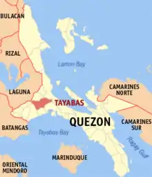
The Spanish colonial bridges in Tayabas are bridges built during the Spanish-colonial era in Tayabas, Quezon. The city government of Tayabas declared eleven bridges in the city as Historical bridges of Tayabas for protection purposes.[1] These are the bridges of Alitao, Isabel II, Urbiztondo, Don Francisco de Asis, Bai, Despedidas, Ese, Princesa, Malagonlong, Lakawan and Mate. In 2011, ten bridges in Tayabas was declared as National Cultural Treasure under the Historic Bridges of Tayabas.[2] The declared national cultural treasures under the list are the bridges of Alitao, Isabel II, Don Francisco de Asis, Gibanga, Malagonlong, Lakawan, Mate, Ese, Despedida, Tumuloy and Princesa.
Tayabas Historic Bridges
The Tayabas Historic Bridges is a group of existing Spanish-colonial era bridges in Tayabas, Quezon declared by the National Museum of the Philippines as a National Cultural Treasure on August 12, 2011.[2]
| Image | Bridge | Location | Coordinates | Description |
|---|---|---|---|---|
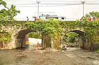 |
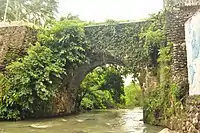
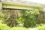
Puente de Alitao | Alitao River, Poblacion | 14°01′34″N 121°35′25″E | A two arched adobe bridge built in 1793 by Don Diego Urbano. It is the earliest surviving colonial bridge in Tayabas. |
 |
Puente de Reina Isabel II | Iyam River, Brgy. Baguio | 14°00′36″N 121°34′52″E | The bridge was constructed under the term of Gobernador Don Jose Maria de la O in March 15, 1852. It was finished in July 16, 1853 and was dedicated to Queen Isabel II of Spain. |
 |
Puente de San Francisco de Asís | Domoit River, Brgy. Domoit | 13°58′06″N 121°32′56″E | Built in 1854 |
| Puente de Gibanga | Brgy. Gibanga | |||
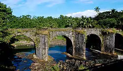 |
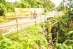
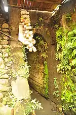
Puente de Malogonlong | Dumacaa River, Brgy Matuena | 14°00′47″N 121°37′01″E | The longest Spanish colonial era bridge in the Philippines built by Franciscan Fr. Antonio Mateos from 1841 to 1850 |
 |
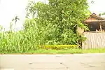
Puente de Lakawan | Lakawan River, Brgy. Lakawan | 14°00′29″N 121°01′42″E | |
 |
Puente de Mate | Mate River, Brgy. Mate | 14°00′18″N 121°38′02″E | |
 |
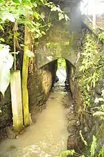
Puente de la Ese | Ibiyang Munti, Brgy. Camaysao | 14°02′12″N 121°35′01″E | |
 |
Puente de las Despedidas | Malaking Ibiya, Brgy. Lalo | 14°05′10″N 121°34′16″E | |
| Puente de Tumuloy | ||||
 |
Puente de la Princesa | Ilayang Dumacaa (Upper Dumacaa), Brgy. Matuena | 14°03′55″N 121°34′20″E |
Other Spanish-colonial era bridges
Besides the declaration of the National Museum on National Cultural Treasures and the city government of Tayabas on historic bridges, all Spanish colonial era bridges are declared cultural properties (part of the Philippine Registry of Cultural Property) under the National Cultural Heritage Act.
| Image | Bridge | Location | Coordinates | Description |
|---|---|---|---|---|
 |
Puente de Baawin | 136.55 Kilometer Post | 14°01′15″N 121°35′14″E | |
 |
Puente de Baguio | Brgy. Baguio | 14°00′57″N 121°35′05″E | |
 |
Puente de Bai | Bai Creek, Brgy. Dapdap | 14°03′46″N 121°33′25″E | |
 |
Puente de Calumpang | Tayabas-Sariaya Provincial Road, Brgy. Calumpang | 13°59′09″N 121°33′48″E | |
 |
Puentecito de Malao-a | Brgy. Malao-a | 14°00′28″N 121°34′42″E | |
 |
Puentecito de Putol | Brgy. Putol | 13°59′51″N 121°34′16″E | |
 |
Puente de Ubli | 14°01′20″N 121°35′16″E | ||
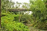 |
Puente de Urbiztondo | Malao-a River, Barangay Malao-a | 14°00′20″N 121°34′52″E | Built in 1854 |
References
- Gonzales, Ana Maria (2006). "Bridging the Past, Present and Future: A Conservation Management Action Plan for Malogonlong Bridge Tayabas, Quezon Province" (PDF). Lund University, Sweden. Retrieved 7 November 2014.
- "Annual Report 2011" (PDF). National Museum of the Philippines. Retrieved November 7, 2014.
External links
| Wikimedia Commons has media related to Spanish colonial bridges in Tayabas. |