Tornado outbreak sequence of April 2–3, 1956
The tornado outbreak sequence of April 2–3, 1956, was a large, deadly tornado outbreak sequence that affected the Great Plains, parts of the South, and the upper Midwest in the contiguous United States.[nb 2] Occurring from April 2–3, 1956, the outbreak produced 47 tornadoes, including an F5 tornado that devastated the Hudsonville and Standale areas in the U.S. state of Michigan on April 3. It was one of three tornadoes to move across southwest Lower Michigan on that day. A fourth tornado struck north of the Manistee area. The Hudsonville-Standale tornado killed 17 and injured 292. These tornadoes were part of a tornado outbreak that took place on April 2–3, 1956, across the U.S Midwest and the Great Lakes regions. In addition to the fatalities in Kansas, Oklahoma, Michigan and Berlin, Wisconsin, three people were killed in Tennessee, one person in Kentucky and two more people in Wisconsin. In total, 38 were killed during the entire event.
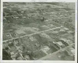 F5 tornado damage in Hudsonville. | |
| Type | Tornado outbreak |
|---|---|
| Duration | April 2–3, 1956 |
| Tornadoes confirmed | 47 confirmed |
| Max. rating1 | F5 tornado |
| Duration of tornado outbreak2 | ~2 days |
| Damage | $58 million (1956 USD)[nb 1] |
| Casualties | 38 fatalities, 638 injuries |
| Areas affected | Central United States |
Part of the tornado outbreaks of 1956 1Most severe tornado damage; see Fujita scale 2Time from first tornado to last tornado | |
Background
| Outbreak death toll[2] | |||
| State | Total | County | County total |
|---|---|---|---|
| Kansas | 2 | Cowley | 1 |
| Elk | 1 | ||
| Kentucky | 1 | Webster | 1 |
| Michigan | 20 | Benzie | 2 |
| Kent | 4 | ||
| Ottawa | 14 | ||
| Oklahoma | 5 | Creek | 5 |
| Tennessee | 3 | Henderson | 3 |
| Wisconsin | 9 | Portage | 2 |
| Green Lake | 7 | ||
| Totals | 38 | ||
| All deaths were tornado-related | |||
Tuesday, April 3, 1956, was a warm and humid day across most of the Midwestern U.S., the Great Lakes and the Ohio Valley. Temperatures in the areas affected by the worst of the outbreak were well into the 70s °F, approaching 80 °F (27 °C) in Michigan, with anomalously high dew points—the latter exceeding 60 °F (16 °C) near the shoreline of Lake Michigan. A potent low-pressure area accompanied an intense mid-latitude cyclone with a pronounced dry line located near the western Great Lakes. An attendant warm front extended eastward over Wisconsin, a vigorous cold front southward through Illinois. In tandem with the advancing trough, a strong jet stream with winds up to 135 kn (155 mph; 250 km/h) extended over Little Rock, Arkansas, and impinged on the Upper Midwest. Prior to the arrival of the storms in the region, schools had closed earlier than usual due to the threat of severe weather. By late afternoon, the cold front crossed over the western Great Lakes including Lake Michigan.[3][4][5]
Tornado table
| FU | F0 | F1 | F2 | F3 | F4 | F5 | Total |
|---|---|---|---|---|---|---|---|
| 0 | 5 | 9 | 18 | 9 | 5 | 1 | 47 |
- In addition to confirmed tornadoes, there were several unconfirmed but possible tornadoes. An F2 tornado may have hit east of Ogdensburg, Wisconsin, destroying a general store and a rural school. Nine barns were damaged or destroyed as well.[6] A tornado may have also overturned two buildings and uprooted trees near Pana, Illinois.[7] In addition to a confirmed F2 tornado near Topeka, Indiana, two other unconfirmed tornadoes may have hit northwest of LaGrange and at Emma, destroying or damaging numerous buildings, including a home and a barn that were blown down, and throwing two people from a horse and buggy, neither of whom was injured.[8]
Confirmed tornadoes
April 2 event
| F# | Location | County / Parish | State | Start coord. |
Time (UTC) | Path length | Max. width | Summary | Refs. |
|---|---|---|---|---|---|---|---|---|---|
| F1 | SE of Allendale | Worth | MO | 40.43°N 94.25°W | 07:00–? | 2.7 miles (4.3 km) | 30 yards (27 m) | A tornado intermittently damaged outbuildings on three farms. | [10][11] |
| F1 | Wilmette | Cook | IL | 42.07°N 87.73°W | 07:30–? | 2 miles (3.2 km) | 10 yards (9.1 m) | A small, short-lived tornado generated minor damage. | [10][12] |
| F1 | Owasso | Tulsa | OK | 36.27°N 95.83°W | 16:30–? | 0.3 miles (480 m) | 33 yards (30 m) | Two outbuildings were destroyed in a brief touchdown over remote areas. | [10][13] |
| F0 | NW of Pawnee Rock | Barton | KS | 38.28°N 99.00°W | 00:00–? | 0.1 miles (160 m) | 33 yards (30 m) | A farm was damaged. | [14][15] |
| F3 | WNW of Claflin to WSW of Holyrood | Ellsworth | KS | 38.53°N 98.55°W | 00:45–? | 5.4 miles (8.7 km) | 33 yards (30 m) | This tornado first formed near Claflin, damaging communication lines outside town. The tornado then struck an oil camp near State Highway 4, damaging small homes. Near Holyrood, the tornado shifted five homes on their foundations, and a gymnasium and bleachers were "torn apart." Grazulis classified the tornado as an F2. | [13][16][17] |
| F3 | SSW of Hopeton to E of Burlington | Woods, Alfalfa | OK | 36.68°N 98.67°W | 01:05–? | 20 miles (32 km) | 400 yards (370 m) | This tornado damaged or destroyed thirty buildings, including twenty homes, and a grain elevator. | [18][17][19][20] |
| F0 | NW of Attica | Harper | KS | 0110 | 0.1 miles (160 m) | A brief tornado "twisted" buildings and uprooted trees. | [7] | ||
| F0 | N of Hunter | Mitchell | KS | 0130 | 3.4 miles (5.5 km) | A tornado damaged farm buildings and transmission lines. | [7] | ||
| F2 | W of Kremlin to SW of Medford | Garfield, Grant | OK | 0145 | 18.4 miles (29.6 km) | A tornado developed north of Enid, striking eight farms in its path. One home was destroyed at the end of the path. According to tornado researcher Thomas P. Grazulis, the tornado was at least F3 in intensity, as two of the farms reportedly sustained near-F4-level damage. | [17] | ||
| F3 | Ellinwood to NW of Holyrood | Barton, Rice, Ellsworth | KS | 0230 | 20.1 miles (32.3 km) | This tornado touched down on the northwest side of Ellinwood at 8:30 p.m. CST, where it caused F1 damage to six planes and two hangars, resulting in $30,000 damage. This storm followed the same path as the first Holyrood event. | [17][7] | ||
| F2 | W of Tonkawa | Kay | OK | 0245 | 0.1 miles (160 m) | Every building on a farm was destroyed except for the farmhouse. Chickens were killed, and farm machinery was also destroyed. The tornado is not listed as significant by Grazulis. | [7][17] | ||
| F1 | N of Tishomingo | Johnston | OK | 0329 | 8 miles (13 km) | Many outbuildings, a metal fence, and a concession stand at a drive-in theater were destroyed. | [7] | ||
| F2 | Skedee to E of Fairfax | Pawnee, Osage | OK | 0330 | 12.6 miles (20.3 km) | One home was destroyed and two homes had their roofs torn off. Barns were destroyed and livestock were killed as well. The tornado was rated F3 by Grazulis. | [17] | ||
| F4 | NE of Kildare to Gridley, KS | Kay (OK), Cowley (KS), Chautauqua (KS), Elk (KS), Greenwood (KS), Woodson (KS), Coffey (KS) | OK, KS | 0330 | 108.3 miles (174.3 km) | 2 deaths – See section on this tornado – 29 people were injured. | [17][7] | ||
| F1 | NE of Whitewater to SE of Florence | Butler, Marion | KS | 0330 | 22.9 miles (36.9 km) | Barns were destroyed and had their debris scattered for miles. A stone weighing 90 pounds (41 kg) was dropped through a roof. The tornado, which was rated F2 by Grazulis, may have been in the same family as the next event. | [17][7] | ||
| F3 | E of Florence to E of Effingham | Marion, Chase, Lyon, Wabaunsee | KS | 0330 | 127 miles (204 km) | See section on this tornado – Four people were injured. | [7][17] | ||
| F3 | E of Fowler to Drumright | Lincoln, Creek | OK | 0333 | 42.6 miles (68.6 km) | 5 deaths – See section on this tornado – 68 people were injured. | [17] | ||
| F2 | SE of Auburn | Nemaha | NE | 0445 | 2.3 miles (3.7 km) | A garage was destroyed. The tornado was not listed as significant by Grazulis. | [7][17] | ||
April 3 event
| F# | Location | County / Parish | State | Start coord. |
Time (UTC) | Path length | Max. width | Summary | Refs. |
|---|---|---|---|---|---|---|---|---|---|
| F3 | SE of Sobol | Pushmataha | OK | 0605 | 2 miles (3.2 km) | All buildings on a farm were destroyed and a school was damaged. This event was listed as an F2 by Grazulis. | [17] | ||
| F4 | SW of Narcissa to SE of Carterville, MO | Ottawa (OK), Cherokee (KS), Jasper (MO) | OK, KS, MO | 0610 | 41.8 miles (67.3 km) | See section on this tornado – 59 people were injured. | [17][7] | ||
| F1 | NW of Sulphur Springs | McDonald | MO | 0630 | 8.8 miles (14.2 km) | Homes sustained roof damage and five barns were destroyed. The tornado was rated F2 by Grazulis. | [17] | ||
| F2 | SE of Avoca | Iowa | WI | 1700 | 3 miles (4.8 km) | A tornado leveled two barns, one of which had its cement block foundation torn out. | [6] | ||
| F2 | N of Thebes | Ashley | AR | 1825 | 2.1 miles (3.4 km) | A tornado damaged a home and destroyed a barn and some sheds. The tornado was not listed as significant by Grazulis. | [7][6] | ||
| F2 | N of Plainfield to NW of Amherst Junction | Portage | WI | 1850 | 18.2 miles (29.3 km) | 2 deaths – Homes and barns were destroyed at eight different locations. The deaths were each in separate buildings. The tornado was rated F3 by Grazulis. | [6] | ||
| F2 | NE of Portland | Chicot | AR | 1900 | 1 mile (1.6 km) | Two homes were destroyed and two others were damaged. Barns and outbuildings were destroyed as well. | [6] | ||
| F4 | SW of Berlin to NW of Omro | Green Lake, Waushara, Winnebago | WI | 1945 | 11.5 miles (18.5 km) | 7 deaths – A factory and at least 20 homes were destroyed, some of which were leveled. Light items from Berlin were found up to 75 miles (121 km) away. | [6] | ||
| F2 | W of Sunflower to Saltillo | Sunflower, Leflore, Grenada, Yalobusha, Calhoun, Lee | MS | 2030 | 124.9 miles (201.0 km) | A long-tracked tornado family began near Lynn, southwest of Ruleville, where at least one home was destroyed. A separate touchdown near Chesterville passed through Belden and Saltillo, destroying four homes and a school gymnasium. | [6][21] | ||
| F2 | Lawrenceville | Lawrence | IL | 2030 | 3.3 miles (5.3 km) | A "large building" was destroyed and a concrete building was damaged, with lumber scattered. Several windows were broken as well. The tornado is not listed as significant by Grazulis. | [7][6] | ||
| F2 | SE of Kempton | Ford | IL | 2200 | 2 miles (3.2 km) | A chicken coop was destroyed, a barn was unroofed, windows were broken, and other buildings were damaged. The tornado is not listed as significant by Grazulis. | [7][6] | ||
| F3 | NE of Dixon to Zion | Webster, Henderson | KY | 2200 | 22.9 miles (36.9 km) | 1 death – One home and several barns were destroyed. Livestock were killed as well. The lone victim was thrown 350 feet (117 yd) from her home. | [6] | ||
| F2 | SW of Weldon to E of De Land | De Witt, Piatt | IL | 2208 | 9.5 miles (15.3 km) | Roofs were torn off homes. Buildings were destroyed on four farms as well. | [6] | ||
| F5 | Saugatuck to Hudsonville to S of Lakeview | Allegan, Ottawa, Kent, Montcalm | MI | 2240 | 58.8 miles (94.6 km) | 17 deaths – See section on this tornado – 292 people were injured. | [3][22][23] | ||
| F4 | Lexington | Henderson | TN | 2245 | 11.6 miles (18.7 km) | 3 deaths – A violent tornado destroyed 46 homes and two businesses in Lexington. In the town, 20 businesses and 250 homes were damaged. Bodies were thrown 100 yards (91 m) from a home that "'exploded'." | [21] | ||
| F1 | SE of Cadwell to SE of Arthur | Moultrie, Douglas | IL | 2300 | 4.5 miles (7.2 km) | ||||
| F2 | SW of Poland | Tippecanoe | IN | 2300 | 0.1 miles (160 m) | A brief tornado unroofed a barn and tore off some roof shingles from a farmhouse. A window was blown out as well. The tornado was not rated as significant by Grazulis. | [7][21] | ||
| F0 | SW of Pride | Union | KY | 2330 | 0.1 miles (160 m) | A brief tornado, probably spawned by the same storm that hit Zion, damaged several residences, a barn, and a garage. | [7] | ||
| F4 | NW of Onekama to E of Suttons Bay | Manistee, Benzie, Grand Traverse, Leelanau | MI | 2335 | 50.3 miles (81.0 km) | 1 death – See section on this tornado – 25 people were injured. | [21][3] | ||
| F2 | W of Salem | Washington | IN | 2345 | 0.1 miles (160 m) | A brief tornado touched down just west of Salem, shifting a large bridge. It destroyed or damaged more than 100 structures in Salem and destroyed numerous barns. One of the victims later died in another tornado on March 19, 1963. StormData listed the tornado as having traveled 15 miles (24 km) while Grazulis rated it an F3. The tornado may have continued to Canton, hitting a church and a school, which would verify his path length of 23 miles (37 km). A freezer was reportedly thrown .5 mi (0.80 km). | [21][24] | ||
| F3 | S of Bangor to S of Lowell | Van Buren, Allegan, Barry, Kent | MI | 0015 | 60.6 miles (97.5 km) | See section on this tornado – 12 people were injured. | [21][3] | ||
| F3 | NE of Gilead | Kosciusko | IN | 0104 | 1.5 miles (2.4 km) | Five cottages were leveled and five others were damaged. The tornado was rated F2 by Grazulis. | [21] | ||
| F2 | Cedarbluff to W of West Point | Clay | MS | 0130 | 5.1 miles (8.2 km) | Two churches along with several homes and barns were destroyed. Livestock was killed as well. | [21] | ||
| F2 | E of Delong | Fulton | IN | 0130 | 4.1 miles (6.6 km) | Many barns were damaged. The tornado was not rated as significant by Grazulis. | [7][21] | ||
| F0 | Jenera | Hancock | OH | 0130 | 0.1 miles (160 m) | A brief touchdown occurred, although it was originally listed as only a funnel cloud aloft. | [7] | ||
| F1 | W of Sulphura | Sumner | TN | 0145 | 0.2 miles (320 m) | Several homes and two barns were destroyed. | [7] | ||
| F1 | SW of Wawaka | Noble | IN | 0150 | 0.1 miles (160 m) | A brief tornado damaged or destroyed six barns, lifting one onto a highway. Another barn "'disintegrated'." The tornado was rated F2 by Grazulis. | [21] | ||
| F2 | SW of Lagrange | LaGrange | IN | 0205 | 0.1 miles (160 m) | Homes were moved, damaged, and unroofed, and four barns were destroyed. As many as three tornadoes may have hit LaGrange County. | [7][21] | ||
| F2 | W of Boston | Wayne | IN | 0230 | 0.1 miles (160 m) | Homes and farms were damaged. The tornado was not rated as significant by Grazulis. | [7][21] | ||
Newkirk, Oklahoma/Grenola–Toronto, Kansas
| F4 tornado | |
|---|---|
| Max. rating1 | F4 tornado |
| Casualties | 2 fatalities, 29 injuries |
| 1Most severe tornado damage; see Fujita scale | |
A long-tracked tornado family of at least two tornadoes—both of which were themselves tornado families—began near Newkirk, Oklahoma. The first tornado (F4) quickly intensified to near-F5 intensity just south of the Oklahoma–Kansas state line. In the area, one home was completely swept away and many trees were debarked. A savings bond from that home was found near Williamsburg, Kansas—more than 100 mi (160 km) from its origin. In Kansas, the F4 tornado passed south of Maple City, east of Grenola, and northwest of Howard. Near Maple City and Otto, a plastic belt was found embedded in a broken tree. F4 damage was reported south of Grenola before the tornado lifted near Howard. The second tornado (F4) formed southwest of Toronto, leveling a seven-room home just north of town. A trailer was destroyed as well, killing a baby inside. Its body was allegedly found 1 mi (1.6 km) away.[17][7]
Jacktown–Drumright, Oklahoma
| F3 tornado | |
|---|---|
| Max. rating1 | F3 tornado |
| Casualties | 5 fatalities, 68 injuries |
| 1Most severe tornado damage; see Fujita scale | |
A long-tracked tornado began near Jacktown and moved north-northeast to Davenport. Eight members of a family were injured in Davenport. The tornado passed west of Stroud and continued into Drumright. In Drumright, 63 homes were destroyed and 203 damaged, with five deaths, four of which were in one family. A church and numerous rural farms were destroyed as well. The tornado was rated F4 by Grazulis.[17]
Cedar Point–Strong City–Eskridge–Nortonville, Kansas
| F3 tornado | |
|---|---|
| Max. rating1 | F3 tornado |
| Casualties | 0 fatalities, 4 injuries |
| 1Most severe tornado damage; see Fujita scale | |
This long-tracked tornado family of five or more tornadoes began near Cedar Point, where it unroofed a home and destroyed a barn. The first member of the family lifted near Cedar Point, and the second tornado developed west of Strong City. Near Strong City, a car was thrown 250 feet (83 yd), injuring the driver. This tornado then lifted and reformed into a third tornado that passed west of Bushong, west of Harveyville, and north of Dover. South of Bushong, a boy was blown through a window and injured his leg. Near Dunlap, the tornado destroyed 16 cottages on Lake Kahola. A fourth tornado likely developed east of Harveyville and passed west of Auburn and through Seabrook. In Seabrook, the tornado broke glass, blew out bricks, and damaged trees and TV aerials. This tornado soon dissipated, and a fifth tornado (F3) touched down near Meriden, passing east of Rock Creek and east of Valley Falls before lifting northwest of Nortonville. F3 damage only occurred in the final 20 mi (32 km) of the path as the tornado destroyed farms and killed cattle, including 19 in a single barn. Damage near Nortonville reached $250,000.[7][17]
Miami–Quapaw, Oklahoma/Baxter Springs, Kansas/Webb City, Missouri
| F4 tornado | |
|---|---|
| Max. rating1 | F4 tornado |
| Casualties | 0 fatalities, 59 injuries |
| 1Most severe tornado damage; see Fujita scale | |
A large, violent, long-tracked tornado touched down just after midnight local time and struck the towns of Miami, Quapaw, and Baxter Springs. F4 damage occurred in Miami and Quapaw, with 46 injuries and 56 homes damaged or destroyed in Miami alone. The tornado destroyed five more homes in Quapaw, with total Oklahoma losses estimated at $500,000. The tornado then crossed the Oklahoma–Kansas state line into Baxter Springs, destroying 14 homes, damaging 13, and causing $125,000 damage, with six injuries reported. A baseball grandstand was destroyed, and trees were uprooted as well. The tornado crossed into Missouri west of Joplin and passed through Webb City, damaging 30 homes and several businesses.[17][7]
Saugatuck–Hudsonville–Standale, Michigan
| F5 tornado | |
|---|---|
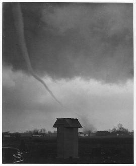 The F5 tornado shortly after formation. | |
| Max. rating1 | F5 tornado |
| Casualties | 17 fatalities, 292 injuries |
| 1Most severe tornado damage; see Fujita scale | |
Officially listed as a single tornado, but may have been a tornado family of two or more tornadoes, one of which was an F4 and the other an F5. The first (F4) tornado may have lifted near Holland, passing aloft over Zeeland before touching down as a second (F5) tornado just east of town. The second tornado then continued northeast before lifting northeast of Trufant.
Just before 5:00 PM CST, a tornado touched down on the beach near Saugatuck, Michigan, and proceeded 9 mi (14 km), producing F4 damage and injuring seven people while destroying barns, outbuildings and garages.[3][22] The tornado destroyed multiple homes, some of which were swept away. The historic lighthouse on the shore near Saugatuck was also leveled by the winds.[3] Some reports indicate that the tornado dissipated near Holland and formed into a new, more powerful tornado southwest of the Grand Rapids metropolitan area at around 6:30 PM.[22][23] Officially, however, a single continuous track is listed.
Beginning in Vriesland in Ottawa County, the F5 tornado moved northeast for 52 mi (84 km) over the southwestern and northern suburbs of Grand Rapids.[23] Homes in Hudsonville were cleanly swept away from their foundations, with only small pieces of debris recovered in some locations. At least one home was so obliterated that all the floor tiles had been completely scoured from the foundation.[3] Vehicles nearby were tossed hundreds of yards and mangled beyond recognition. Extensive wind-rowing of debris was observed, and hundreds of trees were snapped and debarked as well.[23] In all, the tornado destroyed numerous homes and businesses, especially in Standale. Some homes in this area were swept away as well.[3] The tornado continued northeast, destroying a mobile home park before dissipating.[23] Officially, 17 (possibly 18)[21] people were killed and 292 others were injured by the storm. This was the last F5 (confirmed and/or possible) in the U.S. state of Michigan and occurred three years after the Flint Tornado that killed 116.[25]
The tornado that struck the Grand Rapids area was the inspiration for the La Dispute song Hudsonville, MI 1956. Meanwhile, Hudsonville would be hit directly by a brief, but strong F2 tornado just one year later, although that tornado caused no casualties.
Lake Ann–Cedar Run–Bear Lake–Grand Traverse Bay, Michigan
| F4 tornado | |
|---|---|
| Max. rating1 | F4 tornado |
| Casualties | 1 fatality, 25 injuries |
| 1Most severe tornado damage; see Fujita scale | |
This possible tornado family destroyed 13 homes and at least 26 barns before ending over Grand Traverse Bay. Two homes in Benzie County were leveled to the ground, one of which was a multi-story building in which one person died. Other homes were reported destroyed in Lake Ann, southeast of Solon, and in Cedar Run. One barn was also destroyed at Bear Lake. Two people (officially only one) may have died. The tornado affected very rural areas for most of its life, and was rated F3 by Grazulis.[21][3]
Bangor–Allegan–Lowell, Michigan
| F3 tornado | |
|---|---|
| Max. rating1 | F3 tornado |
| Casualties | 0 fatalities, 12 injuries |
| 1Most severe tornado damage; see Fujita scale | |
This "minimal" F3 tornado began on the south side of Bangor and gradually intensified. Near the Van Buren–Allegan County line, it leveled a farmhouse and swept away several small cottages. The tornado also hit the edge of Bloomingdale. In Allegan, the tornado mostly unroofed a factory and a road commission building, and at least 12 farms reported severe losses to livestock. Afterward, the tornado weakened, turned to the right, and lifted before reforming into a new tornado, as no structural damage occurred and damage to vegetation was lighter than elsewhere along the path. The second tornado then re-intensified before badly damaging many farms in Barry and Kent Counties before dissipating near Lowell. In all, the tornado (or tornado family) destroyed 29 homes, one of which was totally leveled in F4 fashion but could not be rated as such due to lack of information about construction quality.[21][3]
Non-tornadic effects
Aftermath and recovery
Notes
- All losses are in 1956 USD unless otherwise noted.
- An outbreak is generally defined as a group of at least six tornadoes (the number sometimes varies slightly according to local climatology) with no more than a six-hour gap between individual tornadoes. An outbreak sequence, prior to (after) the start of modern records in 1950, is defined as a period of no more than two (one) consecutive days without at least one significant (F2 or stronger) tornado.[1]
- All dates are based on the local time zone where the tornado touched down; however, all times are in Coordinated Universal Time for consistency.
- Prior to 1994, only the average widths of tornado paths were officially listed.[9]
References
- Schneider, Russell S.; Brooks, Harold E.; Schaefer, Joseph T. (2004). Tornado Outbreak Day Sequences: Historic Events and Climatology (1875-2003) (PDF). 22nd Conference on Severe Local Storms. Hyannis, Massachusetts: American Meteorological Society. Retrieved 17 September 2019.
- National Weather Service (February 2020). Events reported between 04/02/1956 and 04/03/1956 (2 days) (Report). National Centers for Environmental Information. Retrieved 7 June 2020.
- Ostuno, E. J. (25 June 2008). Written at Grand Rapids, Michigan. Roger Edwards (ed.). "A Case Study in Forensic Meteorology: Investigating the 3 April 1956 Tornadoes in Western Lower Michigan". e-Journal of Severe Storms Meteorology. Norman, Oklahoma. 3 (1): 1–33. Retrieved 7 June 2020.
- "1956 Tornado Outbreak Overview". Grand Rapids, MI Weather Forecast Office. Grand Rapids, Michigan: National Weather Service. Retrieved 7 June 2020.
- "Hudsonville-Standale tornado". WOOD-TV. Grand Rapids, Michigan: WorldNow. 3 April 2006. Archived from the original on 9 September 2007. Retrieved 7 June 2020.
- Grazulis, Thomas P. (July 1993). Significant Tornadoes 1680–1991: A Chronology and Analysis of Events. St. Johnsbury, Vermont: The Tornado Project of Environmental Films. p. 994. ISBN 1-879362-03-1.
- U.S. Weather Bureau (April 1956). "Storm Data and Unusual Weather Phenomena". Climatological Data National Summary. Asheville, North Carolina: National Climatic Data Center. 7 (4): 112.
- USWB 1957, p. 113
- Brooks, Harold E. (April 2004). "On the Relationship of Tornado Path Length and Width to Intensity". Weather and Forecasting. Boston: American Meteorological Society. 19 (2): 310. Bibcode:2004WtFor..19..310B. doi:10.1175/1520-0434(2004)019<0310:OTROTP>2.0.CO;2. Retrieved 11 September 2019.
- USWB 1957, p. 106
- National Weather Service (February 2020). Missouri Event Report: F1 Tornado (Report). National Centers for Environmental Information. Retrieved 8 June 2020.
- National Weather Service (February 2020). Illinois Event Report: F1 Tornado (Report). National Centers for Environmental Information. Retrieved 8 June 2020.
- National Weather Service (February 2020). Oklahoma Event Report: F1 Tornado (Report). National Centers for Environmental Information. Retrieved 9 June 2020.
- USWB 1957, p. 107
- National Weather Service (February 2020). Kansas Event Report: F0 Tornado (Report). National Centers for Environmental Information. Retrieved 9 June 2020.
- National Weather Service (February 2020). Kansas Event Report: F3 Tornado (Report). National Centers for Environmental Information. Retrieved 9 June 2020.
- Grazulis 1993, p. 993
- USWB 1957, p. 108
- National Weather Service (February 2020). Oklahoma Event Report: F3 Tornado (Report). National Centers for Environmental Information. Retrieved 17 June 2020.
- National Weather Service (February 2020). Oklahoma Event Report: F3 Tornado (Report). National Centers for Environmental Information. Retrieved 17 June 2020.
- Grazulis 1993, p. 995
- "The Saugatuck to Holland Tornado". crh.noaa.gov. Grand Rapids, Michigan: National Weather Service. 2 August 2007. Retrieved 17 June 2014.
- "Vriesland to Trufant". crh.noaa.gov. Grand Rapids, Michigan: National Weather Service. 28 September 2009. Retrieved 17 June 2014.
- US Department of Commerce, NOAA. "Tornado Listing". www.weather.gov. Retrieved 24 July 2020.
- Hayden, Jim (3 April 2006). "Five decades ago, titanic tornado took out century-old lighthouse". The Holland Sentinel. Holland, Michigan: Gatehouse Media. Archived from the original on 4 April 2009. Retrieved 7 June 2020.
- Grazulis, Thomas (2003), The Tornado: Nature's Ultimate Windstorm, Norman, Oklahoma: University of Oklahoma Press, ISBN 978-0-8061-3538-0