Henderson County, Kentucky
Henderson County is a county located in the U.S. state of Kentucky. As of the 2010 census, the population was 46,250.[1] The county seat is Henderson.[2] The county was formed in 1798[3] and named for Colonel Richard Henderson[4] who purchased 17,000,000 acres (69,000 km2) of land from the Cherokee Indians, part of which would eventually make up the county.
Henderson County | |
|---|---|
.jpg.webp) Henderson county courthouse in Henderson, Kentucky. | |
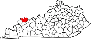 Location within the U.S. state of Kentucky | |
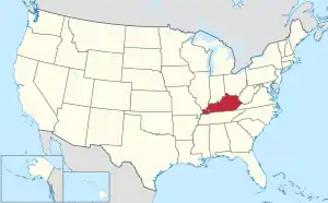 Kentucky's location within the U.S. | |
| Coordinates: 37°48′N 87°34′W | |
| Country | |
| State | |
| Founded | 1798 |
| Named for | Richard Henderson |
| Seat | Henderson |
| Largest city | Henderson |
| Area | |
| • Total | 466 sq mi (1,210 km2) |
| • Land | 437 sq mi (1,130 km2) |
| • Water | 30 sq mi (80 km2) 6.4%% |
| Population | |
| • Estimate (2018) | 45,591 |
| • Density | 106/sq mi (41/km2) |
| Time zone | UTC−6 (Central) |
| • Summer (DST) | UTC−5 (CDT) |
| Congressional district | 1st |
| Website | hendersonky |
Henderson County is part of the Evansville, IN-KY Metropolitan Statistical Area.
History
The Transylvania Co., also known as Richard Henderson & Co., in 1775 purchased from the Cherokees a large swath of wilderness between the Kentucky River and Cumberland River, encompassing approximately half of what would become Kentucky as well as a portion of northern Tennessee. Their intention was to establish a 14th colony to be called Transylvania Colony. To help attract people to purchase land and populate the region, Henderson & Co. hired pioneer, explorer, woodsman, and frontiersman Daniel Boone to lead settlers through Cumberland Gap and direct woodsmen to cut the Wilderness Road through the Kentucky forest. However, the Continental Congress declined to act on Transylvania Co.'s petition without the consent of Virginia and North Carolina, which laid claim to the disputed lands.
In December 1778, Virginia's Assembly finally declared the Transylvania claim void. In compensation, Henderson and his partners received a grant of 12 square miles (31 km2) on the Ohio River below the mouth of Green River. In 1797, the surviving Transylvania Co. investors and heirs directed Samuel Hopkins (congressman), a Revolutionary War colonel, and a surveyor to the Henderson Grant land to lay out a town and mark off land for the respective investors. Hopkins and his surveyor selected a site called Red Banks, Kentucky that sat high above the Ohio River. The town was named Henderson.[5]
Henderson County was established in 1798, using land taken from Christian County.[6]
During the 19th century, a cultivar of dark tobacco raised in Henderson County became very popular in Great Britain and continental Europe. Henderson became the largest dark-tobacco market in the world, generating considerable wealth in Henderson County. Around 1880, Henderson had 17 stemmeries in the city and 18 in the county. Stemmeries were where tobacco was stripped from its stem and made ready for use. [7] However, tobacco production in Henderson County declined through the 20th century and early 21st century, with few farmers still raising the labor-intensive crop. [8]
A peninsula across the Ohio from Henderson, which now forms Union Township, Vanderburgh County, Indiana, was the subject of Handly's Lessee v. Anthony, a U.S. Supreme Court case in 1820.[9] An area known as "Green River Island" is part of Kentucky, even though it is on the Indiana side of the Ohio River. The Ellis Park Race Course is located there.
A workplace shooting occurred at an Atlantis Plastics factory in Henderson, Kentucky, United States on June 25, 2008. The gunman, 25-year-old Wesley Neal Higdon, shot and killed five people and critically injured a sixth, before taking his own life.[10] The mass murder is the worst in the history of Henderson County, surpassing the triple homicides that took place in 1799 and 1955.[11]
Geography
According to the U.S. Census Bureau, the county has a total area of 466 square miles (1,210 km2), of which 437 square miles (1,130 km2) is land and 30 square miles (78 km2) (6.4%) is water.[12] The county's northern border with Indiana is mostly formed by the Ohio River, though some of the county lies north of the river.
Adjacent counties
- Posey County, Indiana (northwest)
- Vanderburgh County, Indiana (north)
- Warrick County, Indiana (northeast)
- Daviess County (east)
- McLean County (southeast)
- Webster County (south)
- Union County (west)
Demographics
| Historical population | |||
|---|---|---|---|
| Census | Pop. | %± | |
| 1800 | 1,468 | — | |
| 1810 | 4,703 | 220.4% | |
| 1820 | 5,714 | 21.5% | |
| 1830 | 6,659 | 16.5% | |
| 1840 | 9,548 | 43.4% | |
| 1850 | 12,171 | 27.5% | |
| 1860 | 14,262 | 17.2% | |
| 1870 | 18,457 | 29.4% | |
| 1880 | 24,515 | 32.8% | |
| 1890 | 29,536 | 20.5% | |
| 1900 | 32,907 | 11.4% | |
| 1910 | 29,352 | −10.8% | |
| 1920 | 27,609 | −5.9% | |
| 1930 | 26,295 | −4.8% | |
| 1940 | 27,020 | 2.8% | |
| 1950 | 30,715 | 13.7% | |
| 1960 | 33,519 | 9.1% | |
| 1970 | 36,031 | 7.5% | |
| 1980 | 40,849 | 13.4% | |
| 1990 | 43,044 | 5.4% | |
| 2000 | 44,829 | 4.1% | |
| 2010 | 46,250 | 3.2% | |
| 2018 (est.) | 45,591 | [13] | −1.4% |
| U.S. Decennial Census[14] 1790–1960[15] 1900–1990[16] 1990–2000[17] 2010–2013[1] | |||
As of the census[18] of 2000, there were 44,829 people, 18,095 households, and 12,576 families residing in the county. The population density was 102 per square mile (39/km2). There were 19,466 housing units at an average density of 44 per square mile (17/km2). The racial makeup of the county was 91.16% White, 7.10% Black or African American, 0.16% Native American, 0.33% Asian, 0.01% Pacific Islander, 0.39% from other races, and 0.86% from two or more races. Hispanic or Latino of any race were 0.97% of the population.
There were 18,095 households, out of which 32.40% had children under the age of 18 living with them, 54.40% were married couples living together, 11.60% had a female householder with no husband present, and 30.50% were non-families. 26.40% of all households were made up of individuals, and 10.60% had someone living alone who was 65 years of age or older. The average household size was 2.43 and the average family size was 2.93.
In the county, the population was spread out, with 24.60% under the age of 18, 8.40% from 18 to 24, 30.00% from 25 to 44, 23.90% from 45 to 64, and 13.10% who were 65 years of age or older. The median age was 37 years. For every 100 females, there were 93.60 males. For every 100 females age 18 and over, there were 90.60 males.
The median income for a household in the county was $35,892, and the median income for a family was $44,703. Males had a median income of $33,838 versus $22,572 for females. The per capita income for the county was $18,470. About 9.70% of families and 12.30% of the population were below the poverty line, including 17.20% of those under age 18 and 10.10% of those age 65 or over.
Communities
Census-designated places
- Anthoston
- Poole (partially in Webster County)
- Spottsville
Other unincorporated places
- Alzey
- Baskett
- Bluff City
- Cairo
- Dixie
- Finley Addition
- Geneva
- Graham Hill
- Hebbardsville
- Niagara
- Reed
- Scuffletown
- Smith Mills
- Weaverton
- Wilson
- Zion
Notable people
- Happy Chandler, 44th and 49th governor of Kentucky; and Commissioner of Baseball from 1945 to 1951. Chandler was born in the farming community of Corydon, Kentucky, in 1898.
- John James Audubon, who went on to fame as an ornithologist, painter and naturalist, lived in Henderson with his young family from 1810 to 1819. John James Audubon State Park, located on the north side of Henderson, is named in his memory.
- W. C. Handy, a musician and composer who became known as the Father of the Blues, lived in Henderson during the 1890s, performing in bands. Handy met his future wife, Elizabeth Price, while performing at a barbecue in Henderson. The annual W. C. Handy Blues & Barbecue Festival, a free event presented in mid-June and launched in 1990, is named in his memory.
- Ewing Galloway, a journalist and one-time county prosecutor, was born in Little Dixie, Kentucky, 1880. He in 1920 founded the Ewing Galloway Agency in New York City, a stock photography agency. By the time of his death 33 years later, his catalog of photos had grown to 400,000 images. Although most, if not all, of the photographs were either purchased from other agencies or shot by employees, the name "Ewing Galloway" appeared beside photos that appeared in books, encyclopedias, schoolbooks and magazine, making his name world-famous. .[19]
- Kentucky clergyman and university president LaVerne Butler was born in Henderson County in 1926.[20]
- Country entertainer Grandpa Jones, a member of the Country Music Hall of Fame, was born in 1913 in the small farming community of Niagara, Kentucky.
- Marine Corporal Luther Skaggs Jr., Medal of Honor recipient for his service during World War II, was born in Henderson, Kentucky, in 1923.
- Command Sergeant Major Gary L. Littrell, Medal of Honor recipient for his service during the Vietnam War, was born in Henderson in 1944.
Politics
| Year | Republican | Democratic | Third parties |
|---|---|---|---|
| 2020 | 61.5% 12,730 | 36.9% 7,639 | 1.6% 328 |
| 2016 | 61.7% 12,159 | 34.0% 6,707 | 4.3% 844 |
| 2012 | 55.3% 10,296 | 43.5% 8,091 | 1.3% 235 |
| 2008 | 48.0% 9,523 | 50.6% 10,049 | 1.5% 289 |
| 2004 | 56.0% 10,467 | 43.3% 8,101 | 0.7% 133 |
| 2000 | 48.0% 7,698 | 50.2% 8,054 | 1.8% 287 |
| 1996 | 34.4% 5,092 | 54.4% 8,051 | 11.2% 1,663 |
| 1992 | 31.8% 5,125 | 51.3% 8,270 | 16.9% 2,731 |
| 1988 | 47.3% 6,911 | 52.3% 7,648 | 0.4% 61 |
| 1984 | 51.9% 7,389 | 47.7% 6,795 | 0.4% 58 |
| 1980 | 37.2% 5,074 | 59.2% 8,082 | 3.7% 503 |
| 1976 | 33.5% 4,053 | 65.3% 7,916 | 1.2% 149 |
| 1972 | 60.7% 6,231 | 37.9% 3,889 | 1.5% 149 |
| 1968 | 32.7% 3,512 | 47.2% 5,062 | 20.1% 2,152 |
| 1964 | 25.4% 2,734 | 74.4% 8,022 | 0.3% 29 |
| 1960 | 48.8% 5,302 | 51.2% 5,565 | 0.0% 0 |
| 1956 | 46.9% 5,085 | 50.8% 5,501 | 2.3% 252 |
| 1952 | 45.3% 4,929 | 54.3% 5,913 | 0.5% 51 |
| 1948 | 24.1% 1,904 | 69.7% 5,499 | 6.2% 486 |
| 1944 | 31.2% 2,683 | 68.5% 5,887 | 0.3% 25 |
| 1940 | 26.7% 2,455 | 73.0% 6,727 | 0.3% 29 |
| 1936 | 20.5% 1,811 | 77.4% 6,835 | 2.1% 187 |
| 1932 | 28.0% 2,485 | 68.7% 6,100 | 3.3% 296 |
| 1928 | 57.0% 5,443 | 42.6% 4,068 | 0.4% 33 |
| 1924 | 53.7% 4,902 | 44.3% 4,046 | 2.0% 186 |
| 1920 | 35.5% 4,161 | 62.1% 7,272 | 2.4% 285 |
| 1916 | 36.4% 2,218 | 60.7% 3,699 | 2.9% 174 |
| 1912 | 21.5% 1,157 | 57.6% 3,098 | 20.9% 1,125 |
References
- "State & County QuickFacts". United States Census Bureau. Archived from the original on June 7, 2011. Retrieved March 8, 2014.
- "Find a County". National Association of Counties. Archived from the original on 2011-05-31. Retrieved 2011-06-07.
- "Henderson County". The Kentucky Encyclopedia. 2000. Retrieved August 22, 2014.
- The Register of the Kentucky State Historical Society, Volume 1. Kentucky State Historical Society. 1903. pp. 35.
- Kleber, John E. (1992). The Kentucky Encyclopedia. The University Press of Kentucky. p. 423. ISBN 0-8131-1772-0. Retrieved 29 April 2020.
- Hogan, Roseann Reinemuth (1992). Kentucky Ancestry: A Guide to Genealogical and Historical Research. Ancestry Publishing. p. 250. ISBN 9780916489496. Retrieved 26 July 2013.
- Dixon, Abby (11 November 2020). "Henderson's Tobacco History". Henderson Tourist Commission. Retrieved 29 April 2020.
- White, Doug (2 October 2017). "Growing tobacco: Henderson family one of few left doing it here". The Gleaner. Henderson, Kentucky. Retrieved 29 April 2020.
- Handly's Lessee v. Anthony, 18 U.S. 374 (1820)
- Lenz, Ryan (2008-06-25). "6 dead in Henderson, Ky., plastics plant shooting". Associated Press. Archived from the original on June 28, 2008.
- Smith, Beth (2008-06-26). "Rampage at Atlantis Plastics ends with six dead". Henderson Gleaner.
- "2010 Census Gazetteer Files". United States Census Bureau. August 22, 2012. Archived from the original on August 12, 2014. Retrieved August 16, 2014.
- "Population and Housing Unit Estimates". Retrieved July 29, 2019.
- "U.S. Decennial Census". United States Census Bureau. Retrieved August 16, 2014.
- "Historical Census Browser". University of Virginia Library. Retrieved August 16, 2014.
- "Population of Counties by Decennial Census: 1900 to 1990". United States Census Bureau. Retrieved August 16, 2014.
- "Census 2000 PHC-T-4. Ranking Tables for Counties: 1990 and 2000" (PDF). United States Census Bureau. Retrieved August 16, 2014.
- "U.S. Census website". United States Census Bureau. Retrieved 2008-01-31.
- "Ewing Galloway Dies of Injury". Kentucky New Era. 29 June 1953. Retrieved 4 June 2013.
- "LaVerne Butler". Lexington Herald Leader, December 18, 2010. Retrieved December 23, 2010.
- Leip, David. "Dave Leip's Atlas of U.S. Presidential Elections". uselectionatlas.org. Retrieved 9 April 2018.
| Central City |  | |
|---|---|---|
| Municipalities with population over 5,000 in 2010 | ||
| Municipalities with population 1,000-5,000 in 2010 | ||
| Indiana Counties | ||
| Kentucky Counties | ||
Municipalities and communities of Henderson County, Kentucky, United States | ||
|---|---|---|
| Cities | Map of Kentucky highlighting Henderson County | |
| CDPs | ||
| Other communities | ||
| Ghost town | ||
| Footnotes | ‡This populated place also has portions in an adjacent county or counties | |
| ||
| Authority control |
|---|