Union County, Kentucky
Union County is a county in the U.S. state of Kentucky. As of the 2010 United States Census, the population was 15,007.[1] Its county seat is Morganfield.[2] The county was created effective 15 January 1811.
Union County | |
|---|---|
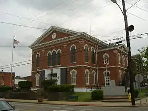 Union County Courthouse in Morganfield | |
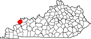 Location within the U.S. state of Kentucky | |
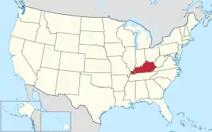 Kentucky's location within the U.S. | |
| Coordinates: 37°40′N 87°57′W | |
| Country | |
| State | |
| Founded | 15 January 1811 |
| Seat | Morganfield |
| Largest city | Morganfield |
| Area | |
| • Total | 363.38 sq mi (941.1 km2) |
| • Land | 342.85 sq mi (888.0 km2) |
| • Water | 20.53 sq mi (53.2 km2) 5.6% |
| Population (2010) | |
| • Total | 15,007 |
| • Estimate (2018) | 14,505 |
| • Density | 42.3/sq mi (16.3/km2) |
| Congressional district | 1st |
| Website | www |
The county is located on the left (east) bank of the Ohio River opposite its confluence with the Wabash River. Union County, along with neighboring Posey County, Indiana, and Gallatin County, Illinois, form the tri-point of the Illinois-Indiana-Kentucky Tri-State Area.
Geography
Union County lies on the northern border of Kentucky; its northwestern border is formed by the meanders of the Ohio River, abutting the states of Illinois and Indiana. The county terrain consists of frequent low wooded hills among the level areas, which are devoted to agriculture.[3] Its highest point (673 feet/205 meters ASL) is a rise in the Chalybeate Hills, in the Higginson-Henry Wildlife Management Area.[4]
The John T. Myers Locks and Dam, authorized and constructed as Uniontown Locks and Dam, is located 3.5 miles (5.6 km) downstream from Uniontown, on the Ohio River, linking Union County and Posey County Indiana. Construction of the dam was begun in 1965 by the U.S. Army Corps of Engineers and completed in 1977. It was renamed on 12 October 1996, to honor retired Indiana congressman John T. Myers.[5]
According to the US Census Bureau, the county has a total area of 363.38 square miles (941.1 km2), of which 342.85 square miles (888.0 km2) is land and 20.53 square miles (53.2 km2) (5.6%) is water.[6] Union County is part of the Western Coal Fields region of Kentucky.
Adjacent counties
- Posey County, Indiana − north
- Henderson County − northeast
- Webster County − southeast
- Crittenden County − south
- Hardin County, Illinois − west
- Gallatin County, Illinois −northwest
Protected areas
Highways
Cities
Census-designated places
Demographics
| Historical population | |||
|---|---|---|---|
| Census | Pop. | %± | |
| 1820 | 3,470 | — | |
| 1830 | 4,764 | 37.3% | |
| 1840 | 6,673 | 40.1% | |
| 1850 | 9,012 | 35.1% | |
| 1860 | 12,791 | 41.9% | |
| 1870 | 13,640 | 6.6% | |
| 1880 | 17,809 | 30.6% | |
| 1890 | 18,229 | 2.4% | |
| 1900 | 21,326 | 17.0% | |
| 1910 | 19,886 | −6.8% | |
| 1920 | 18,040 | −9.3% | |
| 1930 | 17,053 | −5.5% | |
| 1940 | 17,411 | 2.1% | |
| 1950 | 14,893 | −14.5% | |
| 1960 | 14,537 | −2.4% | |
| 1970 | 15,882 | 9.3% | |
| 1980 | 17,821 | 12.2% | |
| 1990 | 16,557 | −7.1% | |
| 2000 | 15,637 | −5.6% | |
| 2010 | 15,007 | −4.0% | |
| 2018 (est.) | 14,505 | [17] | −3.3% |
| US Decennial Census[18] 1790-1960[19] 1900-1990[20] 1990-2000[21] 2010-2013[1] | |||
2010 census
As of the 2010 Census, the population was 15,007. Of this, 85.45% were White, 12.05% were Black or African American, 1.49% were two or more races, 0.44% were some other race, 0.34% were Asian, 0.19% were American Indian or Alaska Native, 0.05% were Native Hawaiian or other Pacific Islander. Hispanic or Latino (of any race) were 1.62% of the population[22]
2000 census
As of the 2000 United States Census,[23] there were 15,637 people, 5,710 households, and 4,082 families in the county. The population density was 45 per square mile (17/km2). There were 6,234 housing units at an average density of 18 per square mile (6.9/km2). The racial makeup of the county was 85.04% White, 12.89% Black or African American, 0.17% Native American, 0.15% Asian, 0.39% from other races, and 1.37% from two or more races. 1.56% of the population were Hispanic or Latino of any race.
There were 5,710 households, out of which 32.10% had children under the age of 18 living with them, 56.50% were married couples living together, 11.40% had a female householder with no husband present, and 28.50% were non-families. 26.10% of all households were made up of individuals, and 12.40% had someone living alone who was 65 years of age or older. The average household size was 2.50 and the average family size was 2.99.
25.30% of the population was under the age of 18, 13.80% from 18 to 24, 25.50% from 25 to 44, 22.50% from 45 to 64, and 12.90% who were 65 years of age or older. The median age was 34 years. For every 100 females there were 101.80 males. For every 100 females age 18 and over, there were 99.30 males.
The median income for a household in the county was $35,018, and the median income for a family was $43,103. Males had a median income of $30,244 versus $20,817 for females. The per capita income for the county was $17,465. About 9.30% of families and 17.70% of the population were below the poverty line, including 18.30% of those under age 18 and 11.70% of those age 65 or over.
Education
Public schools are managed by Union County Public Schools. The three public elementary schools in the county are located in Morganfield, Sturgis, and Uniontown. The county has one public middle school and one public high school, Union County High School. Located near Morganfield, Kentucky, it is known for its wrestling program. St. Ann School, the county's only private school, in Morganfield, holds preschool, elementary, and middle school classes.
Libraries
There are three libraries in Union County, with the main branch in Morganfield and branches in Sturgis and Uniontown.tic experience for grades K-5. The library supplies the county with educational resources such as computers with internet access. There are several programs for children:
- Time for Tots is a range of activities including music, dancing, crafts, stories, and more. For ages 6 months to 5 years;
- Blox’ N Bots is a hands-on robotic experience for grades K-5;
- Between You and Me is a program for middle and high school students and an adult family member. Which includes crafts, games, and activities.
Access to KY Virtual Library provides: • Britannica Digital Learning • Databases • EBSCO • Kentucky Virtual Library • LearningExpress Library • NoveList • ProQuest • Scholastic GO! • TeenBookCloud (pilot) • WorldCat (OCLC)
The Union County Public Library District offers test-proctoring services at the Morganfield location.
Children's online educational resources include: • ABCya • Bob the builder • CoolMath4Kids • Dr. Seuss • Fun with Spot • KidzPage • Little Critter • Littlest Pet Shop • Neopets • Nick Jr. • Nickelodeon • PBS Kids • Ramo Math games • Star Wars • Turtle Diary • Typing games
Ready Reference Links include: Fast Facts, Health, Jobs, Kentucky Driver's Tests, Kentucky Legal Assistance Information, Kentucky Links, Kids, Language, Newspapers, People, Senior Links, Staff Resources, Tax Information, Teen Links, and Union County Links
Politics
Union County was a longtime Democratic stronghold in presidential elections. However, it gradually shifted to supporting Republican candidates. In 2016, Donald Trump won more than three fourths (or 75%) of the county's vote.
| Year | Republican | Democratic | Third parties |
|---|---|---|---|
| 2020 | 75.5% 4,965 | 23.3% 1,529 | 1.3% 83 |
| 2016 | 75.7% 4,701 | 21.4% 1,331 | 2.9% 179 |
| 2012 | 66.2% 3,955 | 32.5% 1,942 | 1.4% 82 |
| 2008 | 51.7% 3,120 | 46.5% 2,804 | 1.8% 110 |
| 2004 | 59.1% 3,534 | 40.1% 2,398 | 0.8% 45 |
| 2000 | 51.2% 2,749 | 47.5% 2,547 | 1.3% 72 |
| 1996 | 30.6% 1,554 | 57.3% 2,913 | 12.1% 617 |
| 1992 | 28.0% 1,605 | 57.9% 3,325 | 14.1% 809 |
| 1988 | 40.7% 2,292 | 58.9% 3,316 | 0.4% 20 |
| 1984 | 44.8% 2,524 | 54.8% 3,090 | 0.4% 23 |
| 1980 | 34.0% 1,847 | 64.0% 3,479 | 2.0% 111 |
| 1976 | 32.3% 1,716 | 66.6% 3,540 | 1.1% 56 |
| 1972 | 58.7% 2,701 | 40.3% 1,855 | 1.0% 48 |
| 1968 | 23.7% 1,371 | 45.2% 2,616 | 31.2% 1,807 |
| 1964 | 23.6% 1,220 | 75.9% 3,934 | 0.5% 27 |
| 1960 | 34.1% 1,789 | 65.9% 3,457 | 0.0% 0 |
| 1956 | 37.7% 1,956 | 55.1% 2,863 | 7.2% 374 |
| 1952 | 36.3% 1,967 | 63.5% 3,445 | 0.2% 10 |
| 1948 | 16.7% 744 | 80.9% 3,607 | 2.5% 110 |
| 1944 | 21.1% 935 | 78.7% 3,489 | 0.3% 12 |
| 1940 | 20.3% 1,111 | 79.6% 4,355 | 0.2% 8 |
| 1936 | 16.7% 965 | 81.5% 4,713 | 1.9% 107 |
| 1932 | 17.7% 1,063 | 81.7% 4,892 | 0.6% 36 |
| 1928 | 37.6% 2,350 | 62.2% 3,884 | 0.1% 9 |
| 1924 | 32.1% 1,778 | 63.0% 3,493 | 5.0% 276 |
| 1920 | 28.0% 1,943 | 70.8% 4,919 | 1.2% 85 |
| 1916 | 29.7% 1,184 | 69.0% 2,754 | 1.4% 54 |
| 1912 | 19.2% 642 | 64.9% 2,168 | 15.9% 530 |
Notable people
- Ben M. Bogard, lived as a child in Union County; became a Baptist minister and was involved with the Landmarkism Movement.
- Dwane Casey, longtime NBA head coach, currently the head coach of the Detroit Pistons.
- Isaiah L. Potts (1784?-after 1843), tavern keeper of the notorious Potts Tavern who, allegedly, ran a gang of highwaymen and murderers on the Illinois frontier
- William L. O'Daniel (1923−2017), a Union County farmer who served in the Illinois General Assembly
References
- "State & County QuickFacts". US Census Bureau. Retrieved March 6, 2014.
- "Find a County". National Association of Counties. Retrieved 7 June 2011.
- Union County KY (Google Maps, accessed 13 October 2020)
- Union County High Point, Kentucky (PeakBagger.com, accessed 13 October 2020)
- "Myers Dam". Locks and Dams Project Office, US Army Corps of Engineers, Louisville District. Archived from the original on January 9, 2009. Retrieved 8 June 2009.
- "2010 Census Gazetteer Files". US Census Bureau. August 22, 2012. Archived from the original on August 12, 2014. Retrieved August 20, 2014.
- Higginson-Henry Wildlife Management Area (Google Maps, accessed 13 October 2020)
- "Higginson-Henry Wildlife Management Area". Kentucky Div of Fish & Wildlife Resources. Retrieved 13 October 2020.
- Moffit Recreation Area (Google Maps, accessed 13 October 2020)
- Boxville KY (Google Maps, accessed 13 October 2020)
- Grangertown KY (Google Maps, accessed 13 October 2020)
- Grove Center KY (Google Maps, accessed 13 October 2020)
- Henshaw KY (Google Maps, accessed 13 October 2020)
- Pride KY (Google Maps, accessed 13 October 2020)
- Spring Grove KY (Google Maps, accessed 13 October 2020)
- The Rocks KY (Google Maps, accessed 13 October 2020)
- "Population and Housing Unit Estimates". Retrieved July 29, 2019.
- "US Decennial Census". US Census Bureau. Retrieved August 20, 2014.
- "Historical Census Browser". University of Virginia Library. Retrieved August 20, 2014.
- "Population of Counties by Decennial Census: 1900 to 1990". US Census Bureau. Retrieved August 20, 2014.
- "Census 2000 PHC-T-4. Ranking Tables for Counties: 1990 and 2000" (PDF). US Census Bureau. Retrieved August 20, 2014.
- "2010 Census Population of Union County, Kentucky - CensusViewer". censusviewer.com.
- "US Census website". US Census Bureau. Retrieved 31 January 2008.
- Leip, David. "Atlas of US Presidential Elections". uselectionatlas.org.
External links
| Wikimedia Commons has media related to Union County, Kentucky. |
Places adjacent to Union County, Kentucky | ||||||||||
|---|---|---|---|---|---|---|---|---|---|---|
| ||||||||||
Municipalities and communities of Union County, Kentucky, United States | ||
|---|---|---|
| Cities | Location of Union County, Kentucky | |
| CDP | ||
| Unincoporated communities | ||
| ||
| Authority control |
|---|