Grant County, Oklahoma
Grant County is a county located on the northern border of the U.S. state of Oklahoma. As of the 2010 census, the population was 4,527.[1] Its county seat is Medford.[2] Originally designated as part of the Cherokee Outlet, it was named County L in Oklahoma Territory at the time of its opening to non-Indian settlement. A county election renamed it for U.S. President Ulysses S. Grant.
Grant County | |
|---|---|
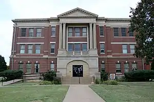 Grant County Courthouse in Medford (2017) | |
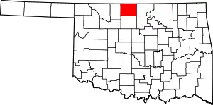 Location within the U.S. state of Oklahoma | |
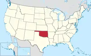 Oklahoma's location within the U.S. | |
| Coordinates: 36°48′N 97°47′W | |
| Country | |
| State | |
| Founded | 1893 |
| Named for | Ulysses S. Grant |
| Seat | Medford |
| Largest city | Medford |
| Area | |
| • Total | 1,004 sq mi (2,600 km2) |
| • Land | 1,001 sq mi (2,590 km2) |
| • Water | 2.7 sq mi (7 km2) 0.3%% |
| Population (2010) | |
| • Total | 4,527 |
| • Estimate (2019) | 4,333 |
| • Density | 4.5/sq mi (1.7/km2) |
| Time zone | UTC−6 (Central) |
| • Summer (DST) | UTC−5 (CDT) |
| Congressional district | 3rd |
| Website | www |
History
Grant County was part of the Cherokee Nation's Cherokee Outlet until it was opened to non-Indian settlers in response to public demand on September 16, 1893. Settlers named the county after President Ulysses S. Grant[3] in a general election held November 6, 1894. Congress originally designated this area as County L in Oklahoma Territory, with the county seat at Pond Creek. Medford became the county seat through an election held on May 27, 1908.[4]
The Chicago, Kansas and Nebraska Railway (later the Chicago, Rock Island and Pacific Railway) built a railroad from northern Kansas through Grant County in 1889 and 1890. In 1897, the Gulf Railroad (later the Atchison, Topeka and Santa Fe Railway, AT&SF) linked Manchester, Wakita, Medford, and Deer Creek. At the start of the 20th century, the Blackwell, Enid and Southwestern Railroad (later the St. Louis and San Francisco Railway) passed through Lamont. Still later, the Denver, Enid and Gulf Railroad (later the AT&SF) reached Nash (Nashville).[4]
The railroads gave the county access to markets in the northern and eastern U.S., helping turn the county into a major agriculture and cattle producer. At statehood, the principal crops were wheat, corn, oats, alfalfa, and forage sorghum. The county also had more than fourteen thousand each of hogs and cattle as well as almost thirteen thousand horses.[4]
Bethel was the site of a post office in Grant County that existed from March 12, 1895, until November 2, 1895.[5]
Florence was the site of a post office in Grant Co. that existed prior to 1908 but ceased to exist circa 1920, after the post office closed, per information acquired in researching an ancestor, Isaac Arnold, who was postmaster in Florence from August 1908 to 1920.
Geography
According to the U.S. Census Bureau, the county has a total area of 1,004 square miles (2,600 km2), of which 1,001 square miles (2,590 km2) is land and 2.7 square miles (7.0 km2) (0.3%) is water.[6] Most of the county is drained by the Salt Fork of the Arkansas River and its tributaries (Pond, Deer, Osage, and Crooked creeks). The Chikaskia River flows southeast from Kansas into the county's northeastern corner, then crosses east into Kay County.[4]
The county is by the U.S. state of Kansas on the north, specifically Sumner and Harper counties. Adjacent counties in Oklahoma are Kay County to the east, Garfield County to the south, and Alfalfa County to the west.
Major highways
Adjacent Counties
- Alfalfa County (west)
- Garfield County (south)
- Harper County, Kansas (northwest)
- Kay County (east)
- Noble County (southeast)
- Sumner County, Kansas (northeast)
Demographics
| Historical population | |||
|---|---|---|---|
| Census | Pop. | %± | |
| 1900 | 17,373 | — | |
| 1910 | 18,670 | 7.5% | |
| 1920 | 16,072 | −13.9% | |
| 1930 | 14,150 | −12.0% | |
| 1940 | 13,128 | −7.2% | |
| 1950 | 10,461 | −20.3% | |
| 1960 | 8,140 | −22.2% | |
| 1970 | 7,117 | −12.6% | |
| 1980 | 6,518 | −8.4% | |
| 1990 | 5,684 | −12.8% | |
| 2000 | 5,144 | −9.5% | |
| 2010 | 4,527 | −12.0% | |
| 2019 (est.) | 4,333 | [7] | −4.3% |
| U.S. Decennial Census[8] 1790-1960[9] 1900-1990[10] 1990-2000[11] 2010-2019[1] | |||
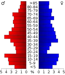
As of the 2010 census, the county's population was 4,527, a 12 percent decline from 5,144 at the 2000 census. The population density was 4.5 people per square mile (1.7/km2). There were 2,622 housing units at an average density of 3 per square mile (1/km2). More than 90 percent of residents self-identified as white. Less than 3 percent of residents self-identified as Native American and less than 2 percent self-identified as Hispanic or Latino of any race. Less than 1 percent of the population self-identified as Black or African American, Asian, or Pacific Islander. Less than 2 percent of the population self-identified as of a race not listed or as from two or more races.
There were 2,089 households, out of which 30.7% had children under the age of 18 living with them, 60.4% were married couples living together, 6.3% had a female householder with no husband present, and 30.30% were non-families. 28.40% of households were made up of individuals, and 15.8% had someone living alone who was 65 years of age or older. The average household size was 2.42 and the average family size was 2.95.
In the county, the population was spread out, with 25.2% under the age of 18, 6.50% from 18 to 24, 24.10% from 25 to 44, 22.80% from 45 to 64, and 21.40% who were 65 years of age or older. The median age was 41 years. For every 100 females there were 94.40 males. For every 100 females age 18 and over, there were 94.80 males.
The median income for a household in the county was $28,977, and the median income for a family was $35,833. Males had a median income of $26,837 versus $19,036 for females. The per capita income for the county was $15,709. About 10.50% of families and 13.70% of the population were below the poverty line, including 19.60% of those under age 18 and 11.90% of those age 65 or over.
Politics
| Voter Registration and Party Enrollment as of January 15, 2019[12] | |||||
|---|---|---|---|---|---|
| Party | Number of Voters | Percentage | |||
| Democratic | 676 | 23.40% | |||
| Republican | 1,917 | 66.36% | |||
| Others | 296 | 10.24% | |||
| Total | 2,889 | 100% | |||
Political Culture
| Year | Republican | Democratic | Third parties |
|---|---|---|---|
| 2020 | 86.1% 1,926 | 12.6% 280 | 1.4% 30 |
| 2016 | 83.0% 1,827 | 13.1% 288 | 3.9% 86 |
| 2012 | 81.0% 1,675 | 19.0% 393 | |
| 2008 | 78.1% 1,836 | 21.9% 514 | |
| 2004 | 77.4% 1,950 | 22.7% 571 | |
| 2000 | 70.4% 1,762 | 28.3% 709 | 1.3% 32 |
| 1996 | 52.1% 1,382 | 32.7% 867 | 15.2% 404 |
| 1992 | 42.9% 1,311 | 28.3% 864 | 28.8% 881 |
| 1988 | 56.7% 1,690 | 41.9% 1,249 | 1.4% 41 |
| 1984 | 74.3% 2,470 | 24.8% 825 | 0.9% 29 |
| 1980 | 69.4% 2,411 | 26.7% 927 | 3.9% 134 |
| 1976 | 47.0% 1,685 | 51.6% 1,853 | 1.4% 50 |
| 1972 | 75.3% 2,829 | 21.4% 805 | 3.2% 121 |
| 1968 | 61.8% 2,403 | 26.9% 1,047 | 11.2% 437 |
| 1964 | 48.4% 1,992 | 51.6% 2,120 | |
| 1960 | 62.0% 2,810 | 38.0% 1,723 | |
| 1956 | 58.8% 2,788 | 41.2% 1,953 | |
| 1952 | 72.4% 3,996 | 27.6% 1,521 | |
| 1948 | 53.8% 2,471 | 46.3% 2,126 | |
| 1944 | 59.5% 3,021 | 40.3% 2,045 | 0.3% 13 |
| 1940 | 53.0% 3,394 | 46.4% 2,970 | 0.6% 38 |
| 1936 | 36.7% 2,307 | 62.8% 3,955 | 0.5% 32 |
| 1932 | 30.0% 1,902 | 70.0% 4,432 | |
| 1928 | 74.3% 4,371 | 24.6% 1,449 | 1.1% 63 |
| 1924 | 51.7% 2,800 | 36.8% 1,990 | 11.5% 622 |
| 1920 | 60.6% 3,210 | 35.5% 1,883 | 3.9% 206 |
| 1916 | 42.3% 1,517 | 47.4% 1,700 | 10.3% 368 |
| 1912 | 47.2% 1,729 | 42.6% 1,559 | 10.2% 373 |
Economy
The county economy has largely been based on agriculture since before statehood. At statehood the principal crops included wheat, corn, oats, alfalfa, and forage sorghum with estimated value of $3.5 million. Farmers and ranchers had more than fourteen thousand each of hogs and cattle as well as almost thirteen thousand horses.[4]
Oil and gas were discovered In the early 1920s in the eastern part of the county near the Blackwell Field. On April 24, 1921, the first oil well in Grant County, was drilled near Deer Creek.[4]
Communities
Cities
Towns
- Deer Creek
- Gibbon
- Jefferson
- Lamont
- Manchester
- Nash
- Renfrow
- Wakita
Unincorporated community
In popular culture
Wakita was featured in the 1996 blockbuster film Twister in which the town was destroyed by an F4 tornado. False fronts were built onto the existing store fronts for pre-tornado shots and then were removed and replaced with rubble in the streets for post-tornado shots.
NRHP sites
The following sites in Grant County are listed on the National Register of Historic Places:
- Bank of Nashville, Nash
- Dayton School, Lamont
- Deer Creek General Merchandise Store, Deer Creek
- Grant County Courthouse, Medford
- Medford Bathhouse and Swimming Pool, Medford
References
- "State & County QuickFacts". United States Census Bureau. Archived from the original on June 6, 2011. Retrieved November 9, 2013.
- "Find a County". National Association of Counties. Archived from the original on May 31, 2011. Retrieved June 7, 2011.
- Gannett, Henry (1905). The Origin of Certain Place Names in the United States. Govt. Print. Off. pp. 141.
- Wilson, Linda D. The Encyclopedia of Oklahoma History and Culture. "Grant County." Accessed January 8, 2017.
- Shirk, Oklahoma Place Names, pg. 23; "No longer in existence."
- "2010 Census Gazetteer Files". United States Census Bureau. August 22, 2012. Retrieved February 21, 2015.
- "County Population Totals: 2010-2019". Retrieved November 11, 2020.
- "U.S. Decennial Census". United States Census Bureau. Archived from the original on April 26, 2015. Retrieved February 21, 2015.
- "Historical Census Browser". University of Virginia Library. Retrieved February 21, 2015.
- Forstall, Richard L., ed. (March 27, 1995). "Population of Counties by Decennial Census: 1900 to 1990". United States Census Bureau. Retrieved February 21, 2015.
- "Census 2000 PHC-T-4. Ranking Tables for Counties: 1990 and 2000" (PDF). United States Census Bureau. April 2, 2001. Retrieved February 21, 2015.
- "Oklahoma Registration Statistics by County" (PDF). OK.gov. January 15, 2019. Retrieved February 27, 2019.
- Leip, David. "Dave Leip's Atlas of U.S. Presidential Elections". uselectionatlas.org. Retrieved March 29, 2018.
Further reading
- Shirk, George H. Oklahoma Place Names. Norman: University of Oklahoma Press, 1987. ISBN 0-8061-2028-2
External links
- Encyclopedia of Oklahoma History and Culture - Grant County
- Oklahoma Digital Maps: Digital Collections of Oklahoma and Indian Territory
Places adjacent to Grant County, Oklahoma | |
|---|---|
Municipalities and communities of Grant County, Oklahoma, United States | ||
|---|---|---|
| Cities | Grant County map | |
| Towns | ||
| Unincorporated communities | ||
| ||
Oklahoma City (capital) | ||
| Topics |
|  |
| Society |
| |
| Regions | ||
| Largest cities | ||
| Counties |
| |
| Authority control |
|---|