National Register of Historic Places listings in Upshur County, West Virginia
This is a list of the National Register of Historic Places listings in Upshur County, West Virginia.
This is intended to be a complete list of the properties and districts on the National Register of Historic Places in Upshur County, West Virginia, United States. The locations of National Register properties and districts for which the latitude and longitude coordinates are included below, may be seen in a Google map.[1]
There are 7 properties and districts listed on the National Register in the county.
- This National Park Service list is complete through NPS recent listings posted January 29, 2021.[2]
Barbour - Berkeley - Boone - Braxton - Brooke - Cabell - Calhoun - Clay - Doddridge - Fayette - Gilmer - Grant - Greenbrier - Hampshire - Hancock - Hardy - Harrison - Jackson - Jefferson - Kanawha - Lewis - Lincoln - Logan - Marion - Marshall - Mason - McDowell - Mercer - Mineral - Mingo - Monongalia - Monroe - Morgan - Nicholas - Ohio - Pendleton - Pleasants - Pocahontas - Preston - Putnam - Raleigh - Randolph - Ritchie - Roane - Summers - Taylor - Tucker - Tyler - Upshur - Wayne - Webster - Wetzel - Wirt - Wood - Wyoming |
Current listings
| [3] | Name on the Register | Image | Date listed[4] | Location | City or town | Description |
|---|---|---|---|---|---|---|
| 1 | Agnes Howard Hall | 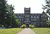 Agnes Howard Hall |
August 18, 1983 (#83003253) |
West Virginia Wesleyan College campus 38°59′22″N 80°13′13″W |
Buckhannon | |
| 2 | Buckhannon Central Residential Historical District |  Buckhannon Central Residential Historical District |
April 16, 2012 (#12000225) |
Roughly bounded by College Ave., S. Kanawha, Madison, & E. Main Sts. 38°59′24″N 80°13′35″W |
Buckhannon | |
| 3 | Downtown Buckhannon Historic District | 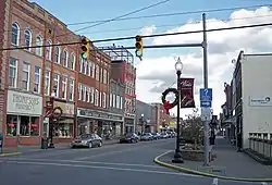 Downtown Buckhannon Historic District |
December 30, 2009 (#09001196) |
Portions of E. and W. Main, N. and S. Florida, Locust, N. and S. Kanawha, and Spring Sts. 38°59′39″N 80°13′48″W |
Buckhannon | |
| 4 | Fidler's Mill | 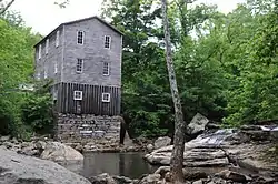 Fidler's Mill |
November 24, 1997 (#97001414) |
Heaston Ridge Rd. 38°47′58″N 80°20′48″W |
Arlington | |
| 5 | French Creek Presbyterian Church | 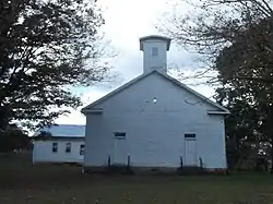 French Creek Presbyterian Church |
December 24, 1974 (#74002020) |
Rte. 2 38°53′06″N 80°18′07″W |
French Creek | |
| 6 | William Post Mansion |  William Post Mansion |
July 13, 1993 (#93000619) |
8 Island Ave. 38°59′45″N 80°13′36″W |
Buckhannon | |
| 7 | Southern Methodist Church Building | 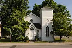 Southern Methodist Church Building |
July 29, 1992 (#92000898) |
81 W. Main St. 38°59′36″N 80°14′01″W |
Buckhannon |
See also
| Wikimedia Commons has media related to National Register of Historic Places in Upshur County, West Virginia. |
References
- The latitude and longitude information provided in this table was derived originally from the National Register Information System, which has been found to be fairly accurate for about 99% of listings. Some locations in this table may have been corrected to current GPS standards.
- "National Register of Historic Places: Weekly List Actions". National Park Service, United States Department of the Interior. Retrieved on January 29, 2021.
- Numbers represent an alphabetical ordering by significant words. Various colorings, defined here, differentiate National Historic Landmarks and historic districts from other NRHP buildings, structures, sites or objects.
- The eight-digit number below each date is the number assigned to each location in the National Register Information System database, which can be viewed by clicking the number.
| Topics | ||
|---|---|---|
| Lists by county |
| |
| Other lists | ||
| ||
Municipalities and communities of Upshur County, West Virginia, United States | ||
|---|---|---|
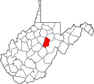
| City | Map of West Virginia highlighting Upshur County | |
| Unincorporated communities |
| |
| Ghost town | ||
| Footnotes | ‡This populated place also has portions in an adjacent county or counties | |
| ||