Bangka Island
Bangka (or sometimes Banka) is an island lying east of Sumatra, administratively used to be part of Sumatra, Indonesia, with a population of about 1 million. It is the 9th largest island in Indonesia[1] and the main part of Bangka-Belitung Province, being one of its namesakes alongside the smaller Belitung across the Gaspar Strait. The provincial capital, Pangkal Pinang, lies on the island. The island is administratively divided into 4 regencies and a chartered city.
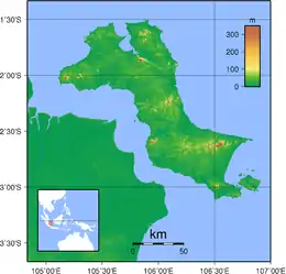
 Topography of Bangka island | |
| Geography | |
|---|---|
| Location | South East Asia |
| Coordinates | 2°15′S 106°00′E |
| Area | 11,693.54 km2 (4,514.90 sq mi) |
| Area rank | 68th |
| Highest elevation | 699 m (2293 ft) |
| Highest point | Mount Maras |
| Administration | |
| Provinces | Pangkal Pinang, Bangka Regency, Central Bangka, South Bangka, West Bangka |
| Largest settlement | Pangkal Pinang (pop. 134,082) |
| Demographics | |
| Demonym | Bangkan |
| Population | 960,692 (2010 Census) |
| Pop. density | 82.65/km2 (214.06/sq mi) |
| Ethnic groups | Malay Indonesians and Chinese, mostly Hakkas |
Geography
Bangka is an island province together with Belitung Island. Bangka lies just east of Sumatra, separated by the Bangka Strait; to the north lies the South China Sea, to the east, across the Gaspar Strait, is the island of Belitung, and to the south is the Java Sea. The size is about 12,000 km². Most of the geographical faces of the island consists of lower plains, swamps, small hills, beautiful beaches, white pepper fields, palm trees and rubber trees also the famous one tin mines.
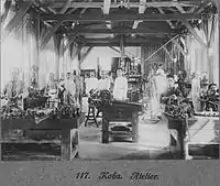
The largest town is Pangkal Pinang which also serves as the capital of Bangka-Belitung Province. Sungai Liat is the second largest city in Bangka island. Mentok (formerly called Muntok) is the principal port in the west. The other important towns are Toboali in the southern region, Koba an important tin mining town, also located on the southern part of the island, and Belinyu, a town famous for its seafood products. There are 4 sea ports in Bangka; Mentok on the far west, Belinyu on the far north, Sadai on the far south, and Pangkal Balam which is in Pangkal Pinang. It was intended that a nuclear power station be built there. [2]
The population was 626,955 in 1990,[3] and 960,692 in the 2010 census; the area is 4,487.87 sq mi (11,623½ km²).
History
During the glacial periods, Bangka was connected to mainland Asia similarly with the larger islands of Java, Sumatra, and Borneo as part of the Sunda Shelf, and got separated once the sea level rose.
The Kota Kapur inscription, dated from 686 CE, was found in Bangka in 1920, showed Srivijayan influence on the island around the 7th century.[4] Later, the island was conquered by an expedition from Majapahit, led by Gajah Mada, which appointed local rulers and established social structures. As the empire declined, Bangka fell into neglect.
Bangka was recorded as Pengjia hill (彭加山) in the 1436 Xingcha Shenglan, compiled by the Chinese soldier Fei Xin during the treasure voyages of Admiral Zheng He. Contemporary records show that the area - close to the busy Strait of Malacca and waters of the Musi River - had significant presence of Chinese traders.[5]
Later on, the island was taken over by the Johor and Minangkabau Sultanates which introduced Islam to the island. It continued to pass to the Banten Sultanate before it was then inherited by the nearby Palembang Sultanate sometime in the late 17th century. Soon after, around 1710, tin was discovered on the island which attracted migrants from across the archipelago and beyond.[6] Descendants of the Chinese immigrants, mainly from Guangdong, still form a large portion of modern Bangka's inhabitants.

As tin mining developed further, the Palembang Sultanate sent for experts in Malay Peninsula and China. The Dutch East India Company managed to secure a monopolistic tin purchase agreement in 1722, but hostilities began to develop between the Sultan and the Dutch. During the British invasion of Java in 1811, then-Sultan Mahmud Badaruddin attacked and massacred the staff of the Dutch post on the island. He was later deposed and executed by the British.[6] His successor ceded Bangka to Britain in 1812, but in 1814 Britain exchanged it with the Dutch for Cochin in India following the Anglo-Dutch Treaty of 1814.

Around the late years of the 18th century, Bangka was an important production center of tin in Asia, with annual outputs hovering around 1,250 tons.[5] In 1930 Bangka had a population of 205,363.[7]Japan occupied the island from February 1942 to August 1945 during World War II. The Japanese military perpetrated the Bangka Island massacre against Australian nurses and British and Australian servicemen and civilians.
During the Indonesian National Revolution, republican leaders Sukarno and Hatta were exiled in Bangka in the aftermath of Operation Kraai. Bangka became part of independent Indonesia in 1949. The island, together with neighboring Belitung, was formerly part of South Sumatra (Sumatera Selatan) province, but in 2000 the two islands became the new province of Bangka-Belitung. In the recent years, tin mining has declined notedly, although it is still a major part of the island's economy.
Bangka is also home to a number of communist Indonesians who have been under house arrest since the 1960s anti-Communist purge and are not permitted to leave the island.
Economy
Since c. 1710, Bangka has been one of the world's principal tin-producing centers. Tin production is an Indonesian government monopoly, and there is a tin smelter at Muntok.[3] White pepper is also produced on the island. Indonesia is the second largest tin producer and exporter in the world. Indonesia's largest tin production is produced in the Bangka Island which makes it a strategic area for Indonesia in terms of world tin trade. But heavy tin exploitation cause environmental damage, many land are suffered from infertility after turned into a tin mine. Irresponsible miners let the mine land become trenches filled with water and the surrounding land is arid with nothing to grow. This become critical environmental issue.
Demographics
The majority of the inhabitants are Malays and Chinese, mostly Hakkas. The population is split between those work on the tin mines, palm oil plantations, rubber plantations, fisherman and those who work on pepper farms.
| Wikimedia Commons has media related to Bangka. |
See also
- Islands of Indonesia
References
- "Largest Islands of Indonesia". Retrieved 4 August 2017.
- "Indonesian Government Eyeing Bangka Island for 2 Nuclear Power Plants". Jakarta Globe. 2010. Retrieved 2013-11-03.
- "Bangka." Columbia Gazetteer of the World Online. 2013. Columbia University Press. 01 Nov. 2013.
- Sujitno, Sutedjo (2011). Legenda dalam sejarah Bangka. Jakarta: Cempaka Publishing. p. 281. OCLC 958845419.
- Utomo, Bambang Budi. "Bangka-Belitung dalam Lintas Niaga" (PDF) (in Indonesian). Indonesian Ministry of Education. Retrieved 4 August 2017.
- Abdullah, Husnial Husin (1983). Sejarah Perjuangan Kemerdekaan R.I. Di Bangka Belitung. Karya Unipress. p. 393.
- Columbia-Lippincott Gazetter