Campo, Colorado
Campo is a statutory town located in Baca County, Colorado, United States, with a population of 109 at the 2010 United States Census.[8] The town is situated in the Great Plains, straddling U.S. Route 287/385.
Campo, Colorado | |
|---|---|
Statutory Town | |
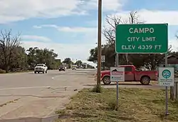 Entering Campo from the north on U.S. Route 287/385. | |
 Location of Campo in Baca County, Colorado. | |
| Coordinates: 37°06′17″N 102°34′44″W[1] | |
| Country | |
| State | |
| County | Baca County[2] |
| Incorporated | March 6, 1950[3] |
| Government | |
| • Type | Statutory Town[2] |
| Area | |
| • Total | 0.14 sq mi (0.37 km2) |
| • Land | 0.14 sq mi (0.37 km2) |
| • Water | 0.00 sq mi (0.00 km2) |
| Elevation | 4,344 ft (1,324 m) |
| Population (2010) | |
| • Total | 109 |
| • Estimate (2019)[6] | 102 |
| • Density | 708.33/sq mi (272.95/km2) |
| Time zone | UTC-7 (MST) |
| • Summer (DST) | UTC-6 (MDT) |
| ZIP code | 81029[7] |
| Area code(s) | 719 |
| FIPS code | 08-11645 |
| GNIS feature ID | 0196360 |
| Website | townofcampo |
Campo is a name derived from Spanish meaning "field".[9] A post office called Campo was established in 1913,[10] and the town grew around it.
Geography
Campo is located just north of the Oklahoma border in southern Baca County at 37°06′17″N 102°34′42″W.[11] Via U.S. Route 287/385 it is 21 miles (34 km) north to Springfield, the county seat, and 27 miles (43 km) south to Boise City, Oklahoma.
According to the United States Census Bureau, the town has a total area of 0.1 square miles (0.26 km2), all of it land.
Picture Canyon, in the Comanche National Grassland, is to the southwest.[12] The canyon includes scenic vistas, unique rock formations, rolling hills, and rock art from Plains Indian cultures.[13]
Climate
| Climate data for Campo, Colorado | |||||||||||||
|---|---|---|---|---|---|---|---|---|---|---|---|---|---|
| Month | Jan | Feb | Mar | Apr | May | Jun | Jul | Aug | Sep | Oct | Nov | Dec | Year |
| Average high °F (°C) | 47 (8) |
51 (11) |
59 (15) |
69 (21) |
78 (26) |
88 (31) |
93 (34) |
91 (33) |
83 (28) |
71 (22) |
58 (14) |
47 (8) |
69.5 (20.8) |
| Average low °F (°C) | 22 (−6) |
25 (−4) |
32 (0) |
40 (4) |
51 (11) |
60 (16) |
66 (19) |
65 (18) |
56 (13) |
43 (6) |
32 (0) |
23 (−5) |
42.9 (6.1) |
| Source: Accuweather[14] | |||||||||||||
Demographics
| Historical population | |||
|---|---|---|---|
| Census | Pop. | %± | |
| 1950 | 266 | — | |
| 1960 | 235 | −11.7% | |
| 1970 | 206 | −12.3% | |
| 1980 | 185 | −10.2% | |
| 1990 | 121 | −34.6% | |
| 2000 | 150 | 24.0% | |
| 2010 | 109 | −27.3% | |
| 2019 (est.) | 102 | [6] | −6.4% |
| U.S. Decennial Census[15] | |||
As of the census[16] of 2000, there were 150 people, 55 households, and 44 families residing in the town. The population density was 1,086.4 people per square mile (413.7/km2). There were 79 housing units at an average density of 572.2 per square mile (217.9/km2). The racial makeup of the town was 95.33% White, 3.33% Native American, and 1.33% from two or more races. Hispanic or Latino of any race were 4.67% of the population.
There were 55 households, out of which 40.0% had children under the age of 18 living with them, 70.9% were married couples living together, 5.5% had a female householder with no husband present, and 20.0% were non-families. 18.2% of all households were made up of individuals, and 10.9% had someone living alone who was 65 years of age or older. The average household size was 2.73 and the average family size was 3.11.
In the town, the population was spread out, with 30.7% under the age of 18, 4.7% from 18 to 24, 25.3% from 25 to 44, 22.7% from 45 to 64, and 16.7% who were 65 years of age or older. The median age was 38 years. For every 100 females, there were 105.5 males. For every 100 females age 18 and over, there were 92.6 males.
The median income for a household in the town was $20,875, and the median income for a family was $21,375. Males had a median income of $19,167 versus $19,375 for females. The per capita income for the town was $7,818. There were 33.3% of families and 45.6% of the population living below the poverty line, including 73.2% of under eighteens and 8.3% of those over 64.
Appearances in film
The town was used as a location for a scene in the 1982 film Savannah Smiles.
See also
- Outline of Colorado
- State of Colorado
- Colorado cities and towns
- Colorado municipalities
- Colorado counties
- Colorado cities and towns
References
- "2014 U.S. Gazetteer Files: Places". United States Census Bureau. July 1, 2014. Retrieved January 5, 2015.
- "Active Colorado Municipalities". State of Colorado, Department of Local Affairs. Archived from the original on 2009-12-12. Retrieved 2007-09-01.
- "Colorado Municipal Incorporations". State of Colorado, Department of Personnel & Administration, Colorado State Archives. 2004-12-01. Retrieved 2007-09-02.
- "2019 U.S. Gazetteer Files". United States Census Bureau. Retrieved July 1, 2020.
- "US Board on Geographic Names". United States Geological Survey. 2007-10-25. Retrieved 2008-01-31.
- "Population and Housing Unit Estimates". United States Census Bureau. May 24, 2020. Retrieved May 27, 2020.
- "ZIP Code Lookup". United States Postal Service. Archived from the original (JavaScript/HTML) on September 3, 2007. Retrieved September 4, 2007.
- "Geographic Identifiers: 2010 Demographic Profile Data (G001): Campo town, Colorado". U.S. Census Bureau, American Factfinder. Archived from the original on February 12, 2020. Retrieved September 25, 2013.
- Dawson, John Frank (1954). Place names in Colorado: why 700 communities were so named, 150 of Spanish or Indian origin. Denver, CO: The J. Frank Dawson Publishing Co. p. 12.
- "Post offices". Jim Forte Postal History. Archived from the original on 6 March 2016. Retrieved 24 June 2016.
- "US Gazetteer files: 2010, 2000, and 1990". United States Census Bureau. 2011-02-12. Retrieved 2011-04-23.
- "Campo, Colorado to Picture Canyon, CO". Google Maps. Retrieved January 3, 2021.
- "Picture Canyon". USDA Forest Service. Retrieved January 3, 2021.
- "Campo Weather". Retrieved May 27, 2015.
- "Census of Population and Housing". Census.gov. Retrieved June 4, 2015.
- "U.S. Census website". United States Census Bureau. Retrieved 2008-01-31.
External links
| Wikimedia Commons has media related to Campo, Colorado. |
Municipalities and communities of Baca County, Colorado, United States | ||
|---|---|---|
| Towns | 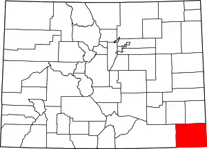 Map of Colorado highlighting Baca County | |
| Unincorporated communities | ||
| ||
