Chaffee County, Colorado
Chaffee County is one of the 64 counties of the U.S. state of Colorado. As of the 2010 census, the population was 17,809.[3] The county seat is Salida.[4]
Chaffee County | |
|---|---|
| County of Chaffee | |
.JPG.webp) Old Chaffee County Courthouse | |
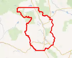
Interactive map of Chaffee County | |
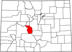 Location within the U.S. state of Colorado | |
| Country | |
| State | |
| Established | February 10, 1879 |
| Named for | Jerome B. Chaffee |
| County seat | Salida |
| Largest city | Salida |
| Area | |
| • Total | 1,015 sq mi (2,630 km2) |
| • Land | 1,013 sq mi (2,620 km2) |
| • Water | 1.6 sq mi (4 km2) 0.2% |
| Highest elevation | 14,421 ft (4,396 m) |
| Population | |
| • Estimate (2019) | 20,356[2] |
| • Density | 18/sq mi (7/km2) |
| Time zone | UTC−7 (Mountain) |
| • Summer (DST) | UTC−6 (MDT) |
| Area code | 970 |
| FIPS code | 08015 |
| GNIS feature ID | 198123 |
| Website | www.chaffeecounty.org |

History
Chaffee County has a confusing origin. Between February 8 and February 10, 1879, Carbonate County was created by the Colorado legislature out of northern Lake County. On February 10 the two counties were renamed, with the southern part of Lake County becoming Chaffee County, and Carbonate County becoming Lake County. Chaffee County is known as the “Heart of the Rockies”. It was named for Jerome B. Chaffee,[5] Colorado's first United States Senator.
Geography
According to the U.S. Census Bureau, the county has a total area of 1,015 square miles (2,630 km2), of which 1,013 square miles (2,620 km2) is land and 1.6 square miles (4.1 km2) (0.2%) is water.[6]
Adjacent counties
- Lake County - north
- Park County - northeast
- Fremont County - southeast
- Saguache County - south
- Gunnison County - west
- Pitkin County - northwest
Major Highways
 U.S. Highway 24
 U.S. Highway 50
 U.S. Highway 285
 State Highway 291
 State Highway 306
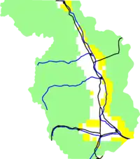
National protected areas
Recreation area
Bicycle routes
Demographics
| Historical population | |||
|---|---|---|---|
| Census | Pop. | %± | |
| 1880 | 6,512 | — | |
| 1890 | 6,612 | 1.5% | |
| 1900 | 7,085 | 7.2% | |
| 1910 | 7,622 | 7.6% | |
| 1920 | 7,753 | 1.7% | |
| 1930 | 8,126 | 4.8% | |
| 1940 | 8,109 | −0.2% | |
| 1950 | 7,168 | −11.6% | |
| 1960 | 8,298 | 15.8% | |
| 1970 | 10,162 | 22.5% | |
| 1980 | 13,227 | 30.2% | |
| 1990 | 12,684 | −4.1% | |
| 2000 | 16,242 | 28.1% | |
| 2010 | 17,809 | 9.6% | |
| 2019 (est.) | 20,356 | [7] | 14.3% |
| U.S. Decennial Census[8] 1790-1960[9] 1900-1990[10] 1990-2000[11] 2010-2015[3] | |||
At the 2000 census there were 16,242 people, 6,584 households, and 4,365 families living in the county. The population density was 16 people per square mile (6/km2). There were 8,392 housing units at an average density of 8 per square mile (3/km2). The racial makeup of the county was 90.94% White, 1.58% Black or African American, 1.09% Native American, 0.44% Asian, 0.05% Pacific Islander, 4.21% from other races, and 1.69% from two or more races. 8.58% of the population were Hispanic or Latino of any race.[12] Of the 6,584 households 25.20% had children under the age of 18 living with them, 56.70% were married couples living together, 6.80% had a female householder with no husband present, and 33.70% were non-families. 28.40% of households were one person and 11.20% were one person aged 65 or older. The average household size was 2.26 and the average family size was 2.77.
The age distribution was 19.70% under the age of 18, 7.70% from 18 to 24, 28.00% from 25 to 44, 27.50% from 45 to 64, and 17.00% 65 or older. The median age was 42 years. For every 100 females, there were 113.60 males. For every 100 females age 18 and over, there were 116.20 males.
The median household income was $34,368 and the median family income was $42,043. Males had a median income of $30,770 versus $22,219 for females. The per capita income for the county was $19,430. About 7.40% of families and 11.70% of the population were below the poverty line, including 17.30% of those under age 18 and 10.20% of those age 65 or over.
Chaffee County is also home to a source of water that Arrowhead water uses for some water bottles. The source is Ruby Mountain Springs.
Politics
Chaffee County is a bellwether county, having supported the winner of 10 out of the last 11 presidential elections. Ironically, the one time that Chaffee County got it wrong was in 2008 when John McCain won the county despite Barack Obama winning in a landslide nationwide.
| Year | Republican | Democratic | Others |
|---|---|---|---|
| 2020 | 45.4% 6,222 | 52.2% 7,160 | 2.4% 335 |
| 2016 | 47.9% 5,391 | 43.5% 4,888 | 8.6% 971 |
| 2012 | 48.5% 5,070 | 48.6% 5,086 | 2.9% 306 |
| 2008 | 49.1% 4,873 | 49.0% 4,862 | 1.9% 186 |
| 2004 | 55.6% 4,875 | 42.9% 3,766 | 1.5% 129 |
| 2000 | 56.5% 4,300 | 36.4% 2,768 | 7.1% 542 |
| 1996 | 42.5% 2,768 | 46.9% 3,052 | 10.7% 695 |
| 1992 | 36.4% 2,284 | 38.5% 2,419 | 25.1% 1,579 |
| 1988 | 53.9% 3,080 | 44.6% 2,548 | 1.5% 86 |
| 1984 | 66.3% 3,680 | 32.1% 1,779 | 1.6% 91 |
| 1980 | 60.7% 3,327 | 28.9% 1,583 | 10.4% 568 |
| 1976 | 56.7% 2,925 | 40.0% 2,064 | 3.4% 173 |
| 1972 | 66.6% 2,859 | 31.6% 1,354 | 1.8% 78 |
| 1968 | 51.1% 2,121 | 40.1% 1,667 | 8.8% 365 |
| 1964 | 37.4% 1,476 | 62.3% 2,463 | 0.3% 12 |
| 1960 | 52.1% 2,094 | 47.8% 1,918 | 0.1% 4 |
| 1956 | 63.7% 2,284 | 36.3% 1,303 | 0.0% 0 |
| 1952 | 56.7% 2,171 | 42.9% 1,643 | 0.4% 15 |
| 1948 | 57.7% 2,065 | 41.2% 1,476 | 1.1% 39 |
| 1944 | 48.8% 1,675 | 50.5% 1,731 | 0.7% 24 |
| 1940 | 46.9% 1,933 | 52.2% 2,153 | 0.9% 35 |
| 1936 | 29.2% 1,069 | 66.8% 2,447 | 4.0% 148 |
| 1932 | 29.2% 1,061 | 66.0% 2,393 | 4.8% 174 |
| 1928 | 59.5% 1,880 | 38.9% 1,230 | 1.6% 50 |
| 1924 | 43.4% 1,336 | 19.9% 612 | 36.7% 1,130 |
| 1920 | 52.9% 1,501 | 43.5% 1,233 | 3.6% 103 |
| 1916 | 24.6% 864 | 72.5% 2,546 | 2.9% 103 |
| 1912 | 21.3% 723 | 48.3% 1,641 | 30.4% 1,031 |
Communities
City
Towns
Census-designated places
Unincorporated communities
See also
References
- Mount Harvard
- "Population and Housing Unit Estimates". U.S. Census Bureau. August 15, 2017. Retrieved August 15, 2017.
- "State & County QuickFacts". United States Census Bureau. Archived from the original on July 8, 2011. Retrieved January 25, 2014.
- "Find a County". National Association of Counties. Archived from the original on 2011-05-31. Retrieved 2011-06-07.
- Gannett, Henry (1905). The Origin of Certain Place Names in the United States. Govt. Print. Off. pp. 74.
- "US Gazetteer files: 2010, 2000, and 1990". United States Census Bureau. 2011-02-12. Retrieved 2011-04-23.
- "Population and Housing Unit Estimates". Retrieved December 3, 2019.
- "U.S. Decennial Census". United States Census Bureau. Retrieved June 7, 2014.
- "Historical Census Browser". University of Virginia Library. Retrieved June 7, 2014.
- "Population of Counties by Decennial Census: 1900 to 1990". United States Census Bureau. Retrieved June 7, 2014.
- "Census 2000 PHC-T-4. Ranking Tables for Counties: 1990 and 2000" (PDF). United States Census Bureau. Retrieved June 7, 2014.
- "U.S. Census website". United States Census Bureau. Retrieved 2011-05-14.
- Leip, David. "Dave Leip's Atlas of U.S. Presidential Elections". uselectionatlas.org. Retrieved May 26, 2017.
External links
| Wikimedia Commons has media related to Chaffee County, Colorado. |
- Cultural, Historical and Archeological Resources
- Chaffee County Clerk of Court
- Chaffee County Government website
- Colorado County Evolution by Don Stanwyck
- Colorado Historical Society
- Geologic Map of the Harvard Lakes 7.5ʹ Quadrangle, Park and Chaffee Counties, Colorado United States Geological Survey
Places adjacent to Chaffee County, Colorado | ||||||||||
|---|---|---|---|---|---|---|---|---|---|---|
| ||||||||||
Municipalities and communities of Chaffee County, Colorado, United States | ||
|---|---|---|
| City | Map of Colorado highlighting Chaffee County | |
| Towns | ||
| CDPs | ||
| Unincorporated communities | ||
| ||

| Authority control |
|---|