Canlaon
Canlaon, officially the City of Canlaon (Cebuano: Dakbayan sa Canlaon; Hiligaynon: Dakbanwa sg Kanglaon; Tagalog: Lungsod ng Canlaon), is a 4th class component city in the province of Negros Oriental, Philippines. According to the 2015 census, it has a population of 54,509 people. [3]
Canlaon | |
|---|---|
| City of Canlaon | |
 Sunset taken at Kanlaon Volcano's slope | |
 Seal | |
| Nickname(s): The Vegetable Capital of Negros Island | |
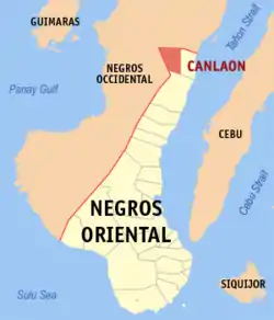 Map of Negros Oriental with Canlaon highlighted | |
OpenStreetMap 
| |
.svg.png.webp) Canlaon Location within the Philippines | |
| Coordinates: 10°23′N 123°12′E | |
| Country | |
| Region | Central Visayas (Region VII) |
| Province | Negros Oriental |
| District | 1st district |
| Founded | October 11, 1946 |
| Cityhood | July 2, 1967 |
| Barangays | 12 (see Barangays) |
| Government | |
| • Type | Sangguniang Panlungsod |
| • Mayor | Jose Chubasco B. Cardenas |
| • Vice Mayor | Jimmy Jayme L. Clerigo |
| • Representative | Jocelyn S. Limkaichong |
| • Electorate | 34,261 voters (2019) |
| Area | |
| • Total | 170.93 km2 (66.00 sq mi) |
| Elevation | 385 m (1,263 ft) |
| Highest elevation | 2,465 m (8,087 ft) |
| Population | |
| • Total | 54,509 |
| • Density | 320/km2 (830/sq mi) |
| • Households | 12,624 |
| Economy | |
| • Income class | 4th city income class |
| • Poverty incidence | 34.95% (2015)[4] |
| • Revenue | ₱374,698,110.35 (2016) |
| Time zone | UTC+8 (PST) |
| ZIP code | 6223 |
| PSGC | |
| IDD : area code | +63 (0)35 |
| Climate type | tropical climate |
| Native languages | Cebuano Hiligaynon Tagalog |
It is located 168 kilometres (104 mi) north from the provincial capital Dumaguete and is bordered on the east by Vallehermoso and on the south by Guihulngan.
Canlaon is home to the highest peak in its own province and its corresponding island, Kanlaon Volcano, which is 2,465 metres (8,087 ft) above sea level at its highest point.
The Banyan Tree inside the OISCA Farm is estimated by botanists from Silliman University to be around 1,300 years old. It is home to lizards, bats, and a variety of insects. It may be considered as Canlaon City's main tourist attraction.
History
Canlaon was formerly a part of Vallehermoso as Sitio Mabigo of Barrio Panubigan. In 1941, Isidro Bautista Sr., an geomatic engineer, along with its residents petitioned the Philippine government to convert Mabigo into a separate municipality.
World War II
During the Second World War, the Japanese Imperial Army captured Canlaon City in April 1942, right after the Battle of Bataan. The Japanese occupation of the City ended in early 1945 when soldiers from the Eighth United States Army under Lieutenant General Robert Eichelberger including the 40th Infantry Division (United States) and the 23rd Infantry Division (United States), landed in Negros Island to drive out the Japanese. In liberating Negros Island, they were assisted by newly formed Philippine Commonwealth military forces & local Negrosanon guerillas who helped in clearing out Japanese pockets of resistance throughout the island. In fact, the honor of liberating Canlaon City from the Japanese went to Philippine Commonwealth soldiers belonging to the 7th, 71st, 73rd and 75th Infantry Regiments of the Philippine Army, the 7th Constabulary Regiment of the Philippine Constabulary and Negrosanon Guerillas.
Creation as a municipality
On October 11, 1946, President Manuel Roxas signed Executive Order no. 19, creating the municipality of Canlaon consists of two barrios (Mabigo and Panubigan) and nine sitios. It was inaugurated on January 1, 1947. Bautista Sr. became its first municipal mayor.
Cityhood
Lorenzo Teves, congressman of the first district of Negros Oriental, filed House Bill 4346, regarding the conversion of Canlaon into a city. The bill became Republic Act 3445. However, President Carlos P. Garcia did not signed the bill. It was only on April 20, 1967, when president Ferdinand Marcos signed Proclamation no. 193, making the municipality as a city. It took effect on July 2, 1967, making Canlaon as the 2nd city in the province.
Barangays
Canlaon City is politically subdivided into 13 barangays.
.png.webp)
- Bayog
- Biak na Bato
- Binalbagan
- Bucalan (East Budlasan)
- Budlasan (West Budlasan)
- Linothangan
- Lumapao
- Mabigo (Poblacion – Canlaon Proper)
- Malaiba
- Masulog
- Ninoy Aquino
- Panubigan
- Pula
Climate
| Climate data for Canlaon City, Negros Oriental | |||||||||||||
|---|---|---|---|---|---|---|---|---|---|---|---|---|---|
| Month | Jan | Feb | Mar | Apr | May | Jun | Jul | Aug | Sep | Oct | Nov | Dec | Year |
| Average high °C (°F) | 26 (79) |
27 (81) |
28 (82) |
29 (84) |
28 (82) |
27 (81) |
26 (79) |
27 (81) |
27 (81) |
26 (79) |
26 (79) |
26 (79) |
27 (81) |
| Average low °C (°F) | 20 (68) |
20 (68) |
20 (68) |
21 (70) |
22 (72) |
22 (72) |
22 (72) |
22 (72) |
22 (72) |
22 (72) |
21 (70) |
20 (68) |
21 (70) |
| Average precipitation mm (inches) | 100 (3.9) |
75 (3.0) |
90 (3.5) |
101 (4.0) |
183 (7.2) |
242 (9.5) |
215 (8.5) |
198 (7.8) |
205 (8.1) |
238 (9.4) |
194 (7.6) |
138 (5.4) |
1,979 (77.9) |
| Average rainy days | 14.9 | 11.3 | 14.5 | 17.4 | 26.4 | 28.4 | 28.5 | 27.5 | 26.9 | 28.4 | 24.2 | 17.2 | 265.6 |
| Source: Meteoblue (Use with caution: this is modeled/calculated data, not measured locally.) [5] | |||||||||||||
Demographics
| Year | Pop. | ±% p.a. |
|---|---|---|
| 1948 | 15,874 | — |
| 1960 | 22,884 | +3.09% |
| 1970 | 23,598 | +0.31% |
| 1975 | 29,152 | +4.33% |
| 1980 | 28,785 | −0.25% |
| 1990 | 37,165 | +2.59% |
| 1995 | 41,334 | +2.01% |
| 2000 | 46,548 | +2.58% |
| 2007 | 50,208 | +1.05% |
| 2010 | 50,627 | +0.30% |
| 2015 | 54,509 | +1.42% |
| Source: Philippine Statistics Authority [3] [6] [7][8] | ||
Cebuano is the main dialect of Canlaon City but Hiligaynon is also spoken due to its border with Negros Occidental. Tagalog and English are rather used as second dialects.
References
- City of Canlaon | (DILG)
- "Province:". PSGC Interactive. Quezon City, Philippines: Philippine Statistics Authority. Retrieved 12 November 2016.
- Census of Population (2015). "Region VII (Central Visayas)". Total Population by Province, City, Municipality and Barangay. PSA. Retrieved 20 June 2016.
- "PSA releases the 2015 Municipal and City Level Poverty Estimates". Quezon City, Philippines. Retrieved 12 October 2019.
- "Canlaon: Average Temperatures and Rainfall". Meteoblue. Retrieved 6 May 2020.
- Census of Population and Housing (2010). "Region VII (Central Visayas)". Total Population by Province, City, Municipality and Barangay. NSO. Retrieved 29 June 2016.
- Censuses of Population (1903–2007). "Region VII (Central Visayas)". Table 1. Population Enumerated in Various Censuses by Province/Highly Urbanized City: 1903 to 2007. NSO.
- "Province of". Municipality Population Data. Local Water Utilities Administration Research Division. Retrieved 17 December 2016.
External links
| Wikivoyage has a travel guide for Canlaon. |
- Canlaon Profile at PhilAtlas.com
- Philippine Standard Geographic Code
- Philippine Census Information
- Local Governance Performance Management System
Places adjacent to Canlaon | |
|---|---|
Articles Related to Canlaon | |
|---|---|