Districts of Azad Kashmir
Azad Kashmir is a dependent territory of Pakistan. It has 10 first-order administrative divisions called "districts," and each district is divided into tehsils. Geographically, the northern districts of Azad Kashmir encompass the lower part of the Himalayas. The southern districts of Azad Kashmir, which consist of the Bhimber, Kotli, and Mirpur districts have extremely hot weather in the summer and moderately cold weather in the winter. Azad Kashmir receives rainfall in both the winter and summer seasons, with Muzaffarabad and Pattan being among the wettest areas of Azad Kashmir. The culture in the northern districts is similar to that of the people of Gilgit-Baltistan, where Balti and other languages are spoken. In the central districts like Poonch, etc., the Hindko and Gojri languages are spoken, and in the southern districts, the culture of the people is similar to that of the Potoharis.
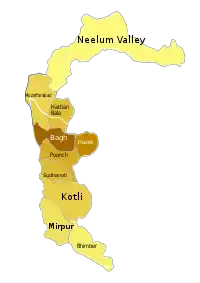
List of Districts
| Map | Sr. No. | District | Headquarters | Area (km2) | Population (2017)[1] | Density (people/km2) |
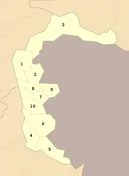 | ||||||
| 1 | Muzaffarabad | Muzaffarabad | 1,642 | 650,370 | 396 | |
| 2 | Hattian Bala | Hattian Bala | 854 | 230,529 | 270 | |
| 3 | Neelam Valley | Athmuqam | 3,621 | 191,251 | 53 | |
| 4 | Mirpur | Mirpur | 1,010 | 456,200 | 452 | |
| 5 | Bhimber | Bhimber | 1,516 | 420,624 | 277 | |
| 6 | Kotli | Kotli | 1,862 | 774,194 | 416 | |
| 7 | Poonch | Rawalakot | 855 | 500,571 | 585 | |
| 8 | Bagh | Bagh | 770 | 371,919 | 483 | |
| 9 | Haveli | Forward Kahuta | 598 | 152,124 | 254 | |
| 10 | Sudhnati | Pallandari | 569 | 297,584 | 523 | |
| Total | 13,297 |
See also
References
- "Statistical Year Book 2019" (PDF). Statistics Azad Jammu and Kashmir. Retrieved 20 April 2020.
Pakistan articles | |||||||||||||||||||
|---|---|---|---|---|---|---|---|---|---|---|---|---|---|---|---|---|---|---|---|
| |||||||||||||||||||
| |||||||||||||||||||
| |||||||||||||||||||
| |||||||||||||||||||
| |||||||||||||||||||
| |||||||||||||||||||
Capital: Muzaffarabad | |
| History | |
| Modern history |
|
| Government and politics |
|
| Culture and places | |
| Geography | |
| Districts | |
| Cities & Town | |
| Economy | |
| Education | |
| Sport |
|
| Others | |