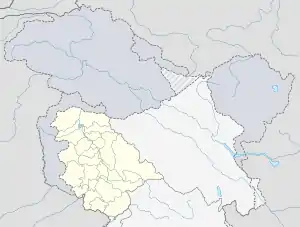
Pattan
Pattan is a town and a municipal committee in Baramulla district in the Indian administered union territory of Jammu and Kashmir.
Pattan | |
|---|---|
village | |
 Pattan Location in Jammu and Kashmir, India  Pattan Pattan (India) | |
| Coordinates: 34.160°N 74.556°E | |
| Country | |
| Union territory | Jammu and Kashmir |
| District | Baramulla |
| Area | |
| • Total | 0.8 km2 (0.3 sq mi) |
| Elevation | 1,553 m (5,095 ft) |
| Population (2006) | |
| • Total | 16,409 |
| • Density | 21,000/km2 (53,000/sq mi) |
| Languages | |
| • Official | Urdu |
| Time zone | UTC+5:30 (IST) |
| PIN | 193121 |
Location
Pattan is surrounded by Breng Block towards North, Kunzer block towards the south, Narbal block towards east, Singhpora block towards west. This place is near the border of the Baramulla, Budgam and Ganderbal districts. Budgam district and Beerwah are south of this place.
Geography
Pattan is located at 34.17°N 74.57°E.[1] It has an average elevation of 1,553 m (5,095 ft). Pattan is one of the historical capitals of Kashmir valley, located nearly in the centre of the valley. Pattan tehsil has remains of four palaces including two in the municipal limits.
Transport
Pattan is accessible through Pattan railway station and Mazhom railway station. However, Jammu Tawi is the major railway station about 290 km (180 mi) from Pattan.
Demographics
As of 2011 India census,[2] Pattan had a population of 19,538 of whom 12,580 are males and 6,958 are female. Literacy rate of Pattan is 74.28% higher than the erstwhile state average of 67.16%. In Pattan, Male literacy is around 83.92% while female literacy rate is 55.91%. Population of children with age of 0-6 is 2,053 which is 10.51% of total population age.
See also
References
- Falling Rain Genomics, Inc - Pattan
- "Census of India 2001: Data from the 2001 Census, including cities, villages and towns (Provisional)". Census Commission of India. Archived from the original on 16 June 2004. Retrieved 1 November 2008.